Estimated Value: $172,273 - $621,000
--
Bed
--
Bath
--
Sq Ft
4,704
Sq Ft Lot
About This Home
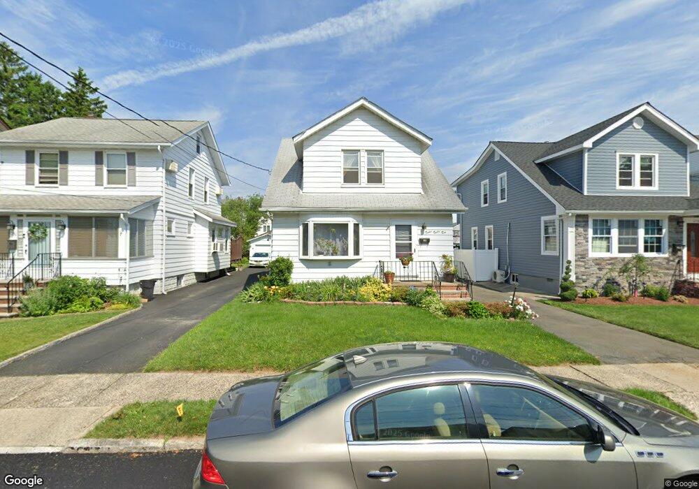
This home is located at 1232 Plane St, Union, NJ 07083 and is currently estimated at $476,318. 1232 Plane St is a home located in Union County with nearby schools including Connecticut Farms Elementary School, Union High School, and St Michael Parish School.
Ownership History
Date
Name
Owned For
Owner Type
Purchase Details
Closed on
Sep 8, 1998
Sold by
Liantonio Gale E
Bought by
Bradshaw Emde E
Current Estimated Value
Home Financials for this Owner
Home Financials are based on the most recent Mortgage that was taken out on this home.
Original Mortgage
$160,100
Outstanding Balance
$34,111
Interest Rate
6.87%
Mortgage Type
VA
Estimated Equity
$442,207
Create a Home Valuation Report for This Property
The Home Valuation Report is an in-depth analysis detailing your home's value as well as a comparison with similar homes in the area
Home Values in the Area
Average Home Value in this Area
Purchase History
| Date | Buyer | Sale Price | Title Company |
|---|---|---|---|
| Bradshaw Emde E | $157,000 | -- |
Source: Public Records
Mortgage History
| Date | Status | Borrower | Loan Amount |
|---|---|---|---|
| Open | Bradshaw Emde E | $160,100 |
Source: Public Records
Tax History Compared to Growth
Tax History
| Year | Tax Paid | Tax Assessment Tax Assessment Total Assessment is a certain percentage of the fair market value that is determined by local assessors to be the total taxable value of land and additions on the property. | Land | Improvement |
|---|---|---|---|---|
| 2025 | $9,812 | $43,900 | $16,700 | $27,200 |
| 2024 | $9,513 | $43,900 | $16,700 | $27,200 |
| 2023 | $9,513 | $43,900 | $16,700 | $27,200 |
| 2022 | $9,182 | $43,900 | $16,700 | $27,200 |
| 2021 | $8,960 | $43,900 | $16,700 | $27,200 |
| 2020 | $8,781 | $43,900 | $16,700 | $27,200 |
| 2019 | $8,663 | $43,900 | $16,700 | $27,200 |
| 2018 | $8,515 | $43,900 | $16,700 | $27,200 |
| 2017 | $8,389 | $43,900 | $16,700 | $27,200 |
| 2016 | $8,185 | $43,900 | $16,700 | $27,200 |
| 2015 | $8,049 | $43,900 | $16,700 | $27,200 |
| 2014 | $7,869 | $43,900 | $16,700 | $27,200 |
Source: Public Records
Map
Nearby Homes
- 1249 Plane St
- 1084 Pine Ave
- 2010 Gless Ave
- 2112 Gless Ave
- 1244 Grandview Ave
- 1231 Glenn Ave
- 1035 Pine Ave
- 7 Jessica Ln
- 2144 Tyler St
- 2021 Tyler St
- 1263 Coolidge Ave
- 1265 Shetland Dr
- 2159 Berwyn St
- 1239 Victor Ave
- 2217 Vauxhall Rd
- 1893 Arbor Ln
- 1120 Weber St
- 1010 Falls Terrace
- 1871 Pilgrim Way
- 987 Floyd Terrace
- 1230 Plane St
- 1236 Plane St
- 1226 Plane St
- 1238 Plane St
- 1224 Plane St
- 1242 Plane St
- 1229 Barbara Ave
- 1227 Barbara Ave
- 1233 Barbara Ave
- 1223 Barbara Ave
- 1235 Barbara Ave
- 1220 Plane St
- 1244 Plane St
- 1221 Barbara Ave
- 1239 Barbara Ave
- 1218 Plane St
- 1217 Barbara Ave
- 1248 Plane St
- 1235 Plane St
- 1237 Plane St