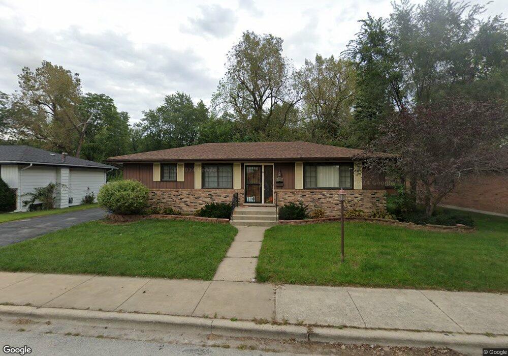
1233 Price Ave Calumet City, IL 60409
Estimated Value: $98,000 - $231,000
3
Beds
2
Baths
1,303
Sq Ft
$124/Sq Ft
Est. Value
About This Home
This home is located at 1233 Price Ave, Calumet City, IL 60409 and is currently estimated at $161,777, approximately $124 per square foot. 1233 Price Ave is a home located in Cook County with nearby schools including Hoover Elementary School, Schrum Memorial Middle School, and Thornton Fractional North High School.
Ownership History
Date
Name
Owned For
Owner Type
Purchase Details
Closed on
Jan 22, 2018
Sold by
The Secretary Of Veterans Affairs
Bought by
Howard Denieke
Current Estimated Value
Purchase Details
Closed on
Sep 13, 2017
Sold by
Woods Jeanette M
Bought by
The Secretary Of Veterans Affairs
Purchase Details
Closed on
Dec 14, 2007
Sold by
Ninkovich Barbara E
Bought by
Woods Jeanette M
Home Financials for this Owner
Home Financials are based on the most recent Mortgage that was taken out on this home.
Original Mortgage
$144,000
Interest Rate
6.3%
Mortgage Type
VA
Purchase Details
Closed on
Apr 20, 1999
Sold by
Ninkovich Barbara E
Bought by
Ninkovich Barbara E and Barbara E Ninkovich Trust
Create a Home Valuation Report for This Property
The Home Valuation Report is an in-depth analysis detailing your home's value as well as a comparison with similar homes in the area
Home Values in the Area
Average Home Value in this Area
Purchase History
| Date | Buyer | Sale Price | Title Company |
|---|---|---|---|
| Howard Denieke | $60,500 | Stewart Title | |
| The Secretary Of Veterans Affairs | $159,718 | Attorney | |
| Woods Jeanette M | $144,000 | Ticor Title | |
| Ninkovich Barbara E | -- | -- |
Source: Public Records
Mortgage History
| Date | Status | Borrower | Loan Amount |
|---|---|---|---|
| Previous Owner | Woods Jeanette M | $144,000 |
Source: Public Records
Tax History Compared to Growth
Tax History
| Year | Tax Paid | Tax Assessment Tax Assessment Total Assessment is a certain percentage of the fair market value that is determined by local assessors to be the total taxable value of land and additions on the property. | Land | Improvement |
|---|---|---|---|---|
| 2024 | $7,891 | $12,000 | $2,831 | $9,169 |
| 2023 | $6,552 | $12,000 | $2,831 | $9,169 |
| 2022 | $6,552 | $7,684 | $2,498 | $5,186 |
| 2021 | $6,429 | $7,684 | $2,498 | $5,186 |
| 2020 | $5,430 | $7,684 | $2,498 | $5,186 |
| 2019 | $7,267 | $9,774 | $2,331 | $7,443 |
| 2018 | $4,742 | $9,774 | $2,331 | $7,443 |
| 2017 | $4,546 | $9,774 | $2,331 | $7,443 |
| 2016 | $4,021 | $8,464 | $2,165 | $6,299 |
| 2015 | $3,877 | $8,464 | $2,165 | $6,299 |
| 2014 | $2,593 | $8,464 | $2,165 | $6,299 |
| 2013 | $2,909 | $9,432 | $2,165 | $7,267 |
Source: Public Records
Map
Nearby Homes
- 305 River Oaks Dr
- 1295 Hirsch Ave
- 1272 Burnham Ave
- 302 161st St
- 1262 Greenbay Ave
- 1295 Greenbay Ave
- 1051 Burnham Ave
- 1304 Freeland Ave
- 1313 Gordon Ave
- 1040 Hirsch Blvd Unit 204
- 1341 Gordon Ave
- 550 Michigan City Rd Unit 3A
- 1317 Mackinaw Ave
- 1354 Hirsch Ave
- 1351 Gordon Ave
- 1366 Price Ave
- 1387 Price Ave
- 1383 Greenbay Ave
- 826 Williams St
- 1373 Stanley Blvd