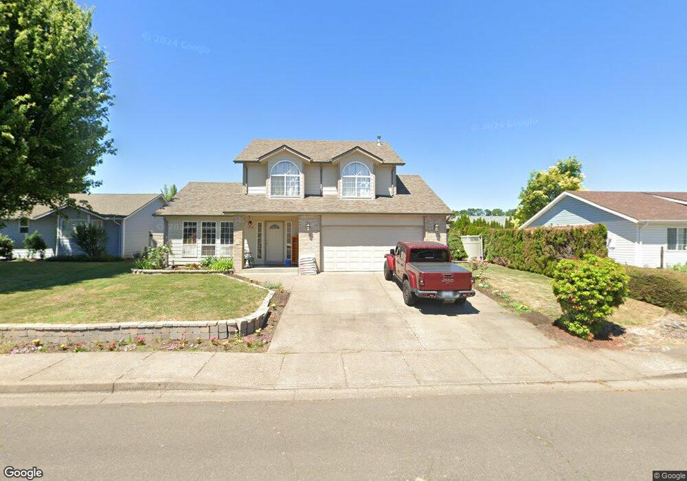
1234 Mickey Ln E Monmouth, OR 97361
Estimated Value: $492,043 - $533,000
4
Beds
3
Baths
1,965
Sq Ft
$260/Sq Ft
Est. Value
About This Home
This home is located at 1234 Mickey Ln E, Monmouth, OR 97361 and is currently estimated at $510,511, approximately $259 per square foot. 1234 Mickey Ln E is a home located in Polk County with nearby schools including Monmouth Elementary School, Talmadge Middle School, and Central High School.
Ownership History
Date
Name
Owned For
Owner Type
Purchase Details
Closed on
Apr 27, 2013
Sold by
Tolzmann Todd L and Tolzmann Teresa L
Bought by
Mentzer Jeffrey and Mentzer Emily
Current Estimated Value
Home Financials for this Owner
Home Financials are based on the most recent Mortgage that was taken out on this home.
Original Mortgage
$218,000
Outstanding Balance
$155,306
Interest Rate
3.6%
Mortgage Type
VA
Estimated Equity
$355,205
Create a Home Valuation Report for This Property
The Home Valuation Report is an in-depth analysis detailing your home's value as well as a comparison with similar homes in the area
Home Values in the Area
Average Home Value in this Area
Purchase History
| Date | Buyer | Sale Price | Title Company |
|---|---|---|---|
| Mentzer Jeffrey | $218,000 | Ticor Title |
Source: Public Records
Mortgage History
| Date | Status | Borrower | Loan Amount |
|---|---|---|---|
| Open | Mentzer Jeffrey | $218,000 |
Source: Public Records
Tax History
| Year | Tax Paid | Tax Assessment Tax Assessment Total Assessment is a certain percentage of the fair market value that is determined by local assessors to be the total taxable value of land and additions on the property. | Land | Improvement |
|---|---|---|---|---|
| 2025 | $4,091 | $278,200 | $76,990 | $201,210 |
| 2024 | $4,091 | $270,100 | $74,750 | $195,350 |
| 2023 | $4,260 | $262,240 | $72,570 | $189,670 |
| 2022 | $3,836 | $254,610 | $70,450 | $184,160 |
| 2021 | $3,792 | $247,200 | $68,400 | $178,800 |
| 2020 | $3,642 | $240,000 | $66,410 | $173,590 |
| 2019 | $3,535 | $233,010 | $64,470 | $168,540 |
| 2018 | $3,414 | $226,230 | $62,600 | $163,630 |
| 2017 | $3,395 | $219,650 | $60,780 | $158,870 |
| 2016 | $3,432 | $213,260 | $59,010 | $154,250 |
Source: Public Records
Map
Nearby Homes
- 932 Olive Way E
- 615 Sacre Ln N
- 1328 Alberta Ave E
- 751 Catron St N
- 435 Gentle Ave E
- 1329 Price Ln E
- 141 S 17th St
- 952 Main St E
- 141 17th (#7) St S Unit 7
- 141 S 17th (#44) St Unit 44
- 738 E Fen Way
- 151 Edwards (#146) Rd S Unit 146
- 148 16th St N
- 510 16th St N
- 151 Edwards Rd S
- 151 Edwards Rd S Unit 147 Rd
- 790 Clay St E
- 260 Jacobson Way S
- Lot 1600 S 16th St
- 9650 Hoffman Rd
- 1208 Mickey Ln E
- 1252 Mickey Ln E
- 1229 Lori Ln E
- 1209 Lori Ln E
- 1253 Lori Ln E
- 1188 Mickey Ln E
- 1231 Mickey Ln E
- 1203 Mickey Ln E
- 1258 Mickey Ln E
- 1181 Lori Ln E
- 1189 Mickey Ln E
- 1160 Mickey Ln E
- 1163 Lori Ln E
- 1210 Lori Ln E
- 1232 Lori Ln E
- 1224 Margaret St E
- 1264 Lori Ln E
- 1260 Margaret St E
- 1206 Margaret St E
- 1161 Mickey Ln E
Your Personal Tour Guide
Ask me questions while you tour the home.