Estimated Value: $381,251 - $615,000
Studio
--
Bath
1,932
Sq Ft
$276/Sq Ft
Est. Value
About This Home
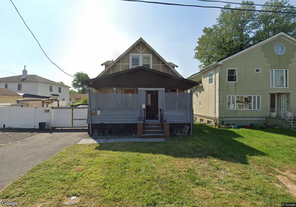
This home is located at 1235 Gray Ave, Union, NJ 07083 and is currently estimated at $533,063, approximately $275 per square foot. 1235 Gray Ave is a home located in Union County with nearby schools including Livingston Elementary School, Union High School, and St Michael Parish School.
Ownership History
Date
Name
Owned For
Owner Type
Purchase Details
Closed on
May 16, 2021
Sold by
Singletary Doris
Bought by
Johnson Altarik
Current Estimated Value
Home Financials for this Owner
Home Financials are based on the most recent Mortgage that was taken out on this home.
Original Mortgage
$307,800
Outstanding Balance
$275,621
Interest Rate
2.9%
Mortgage Type
New Conventional
Estimated Equity
$257,442
Purchase Details
Closed on
Jul 24, 1996
Sold by
Tullis Melvin and Singletary Ray
Bought by
Singletary Doris
Create a Home Valuation Report for This Property
The Home Valuation Report is an in-depth analysis detailing your home's value as well as a comparison with similar homes in the area
Home Values in the Area
Average Home Value in this Area
Purchase History
| Date | Buyer | Sale Price | Title Company |
|---|---|---|---|
| Johnson Altarik | $324,000 | Chicago Title Insurance Co | |
| Singletary Doris | $70,000 | -- |
Source: Public Records
Mortgage History
| Date | Status | Borrower | Loan Amount |
|---|---|---|---|
| Open | Johnson Altarik | $307,800 |
Source: Public Records
Tax History
| Year | Tax Paid | Tax Assessment Tax Assessment Total Assessment is a certain percentage of the fair market value that is determined by local assessors to be the total taxable value of land and additions on the property. | Land | Improvement |
|---|---|---|---|---|
| 2025 | $8,784 | $39,600 | $21,500 | $18,100 |
| 2024 | $8,516 | $39,300 | $21,500 | $17,800 |
| 2023 | $8,516 | $39,300 | $21,500 | $17,800 |
| 2022 | $8,220 | $39,300 | $21,500 | $17,800 |
| 2021 | $8,021 | $39,300 | $21,500 | $17,800 |
| 2020 | $7,861 | $39,300 | $21,500 | $17,800 |
| 2019 | $7,755 | $39,300 | $21,500 | $17,800 |
| 2018 | $7,623 | $39,300 | $21,500 | $17,800 |
| 2017 | $7,510 | $39,300 | $21,500 | $17,800 |
| 2016 | $7,327 | $39,300 | $21,500 | $17,800 |
| 2015 | $7,206 | $39,300 | $21,500 | $17,800 |
| 2014 | $7,044 | $39,300 | $21,500 | $17,800 |
Source: Public Records
Map
Nearby Homes
- 1393 Cornell Place
- 1250 Erhardt St
- 1611 N Sunset Place
- 537 Us Highway 22
- 542 Leo St
- 564 Chapman St
- 525 Us Highway 22
- 292 Crann St
- 386 Yale Ave
- 1453 Morris Ave
- 552 Paul St Unit 8
- 359 Harvard Ave
- 600 Plymouth Rd
- 260 Millard Ave
- 950 Carteret Ave
- 222 Boston Ave
- 985 Arnet Ave
- 969 Arnet Ave
- 130 Valley View Rd
- 875 Salem Rd
- 1231 Gray Ave
- 1400 Cornell Place
- 1390 Cornell Place
- 1238 Roger Ave
- 1244 Roger Ave
- 1236 Roger Ave
- 1211 Gray Ave
- 1230 Gray Ave
- 1234 Gray Ave
- 1228 Gray Ave
- 1240 Gray Ave
- 1224 Gray Ave
- 1230 Roger Ave
- 1410 Cornell Place
- 1220 Gray Ave
- 1228 Roger Ave
- 1215 Gray Ave
- 1227 Brookside Ave
- 1233 Brookside Ave
- 1389 Cornell Place
Your Personal Tour Guide
Ask me questions while you tour the home.