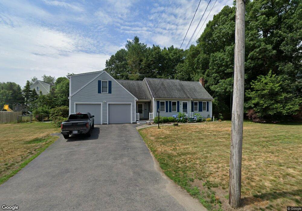
1235 High St Bridgewater, MA 02324
Estimated Value: $651,186 - $693,000
4
Beds
2
Baths
2,237
Sq Ft
$304/Sq Ft
Est. Value
About This Home
This home is located at 1235 High St, Bridgewater, MA 02324 and is currently estimated at $679,797, approximately $303 per square foot. 1235 High St is a home located in Plymouth County with nearby schools including Mitchell Elementary School, Williams Intermediate School, and Bridgewater Middle School.
Ownership History
Date
Name
Owned For
Owner Type
Purchase Details
Closed on
Jul 28, 2008
Sold by
Polillio George D and Polillio Robyn M
Bought by
Soley Richard and Ponzo Michelle
Current Estimated Value
Home Financials for this Owner
Home Financials are based on the most recent Mortgage that was taken out on this home.
Original Mortgage
$304,350
Interest Rate
6.35%
Mortgage Type
Purchase Money Mortgage
Purchase Details
Closed on
Oct 9, 1998
Sold by
Coelho Mark A and Coelho Debra A
Bought by
Polillo George D and Polillo Robyn M
Home Financials for this Owner
Home Financials are based on the most recent Mortgage that was taken out on this home.
Original Mortgage
$174,800
Interest Rate
6.92%
Mortgage Type
Purchase Money Mortgage
Create a Home Valuation Report for This Property
The Home Valuation Report is an in-depth analysis detailing your home's value as well as a comparison with similar homes in the area
Home Values in the Area
Average Home Value in this Area
Purchase History
| Date | Buyer | Sale Price | Title Company |
|---|---|---|---|
| Soley Richard | $345,000 | -- | |
| Polillo George D | $218,500 | -- |
Source: Public Records
Mortgage History
| Date | Status | Borrower | Loan Amount |
|---|---|---|---|
| Open | Polillo George D | $317,053 | |
| Closed | Polillo George D | $304,350 | |
| Previous Owner | Polillo George D | $328,000 | |
| Previous Owner | Polillo George D | $174,800 |
Source: Public Records
Tax History Compared to Growth
Tax History
| Year | Tax Paid | Tax Assessment Tax Assessment Total Assessment is a certain percentage of the fair market value that is determined by local assessors to be the total taxable value of land and additions on the property. | Land | Improvement |
|---|---|---|---|---|
| 2025 | $7,034 | $594,600 | $185,800 | $408,800 |
| 2024 | $6,886 | $567,200 | $176,900 | $390,300 |
| 2023 | $6,814 | $530,700 | $165,300 | $365,400 |
| 2022 | $6,675 | $466,100 | $145,000 | $321,100 |
| 2021 | $4,783 | $420,100 | $129,500 | $290,600 |
| 2020 | $4,933 | $398,100 | $124,500 | $273,600 |
| 2019 | $5,761 | $388,500 | $124,500 | $264,000 |
| 2018 | $5,572 | $366,800 | $120,900 | $245,900 |
| 2017 | $5,364 | $343,600 | $120,900 | $222,700 |
| 2016 | $5,120 | $329,500 | $118,600 | $210,900 |
| 2015 | $5,146 | $316,900 | $115,100 | $201,800 |
| 2014 | $5,038 | $310,000 | $111,700 | $198,300 |
Source: Public Records
Map
Nearby Homes
- 0 Three Rivers Dr
- 215 Whitman St
- Lot 1 Mill St
- 114 Plain St
- 225 Whitman St
- 81 Arrowhead Dr
- 23 Stone Meadow Dr
- 67 Country Dr
- 57 Country Dr
- 24 High Pond Dr
- 96 Trailwood Dr
- 58 Roberts Rd
- 1397 Plymouth St Unit 1397
- 580 Broad St Unit 2
- 580 Broad St Unit 1
- 34 Rolling Hills Dr
- 20 Church Ave
- 29 Douglas Dr
- 167 Spring St
- 4 Sycamore Ln