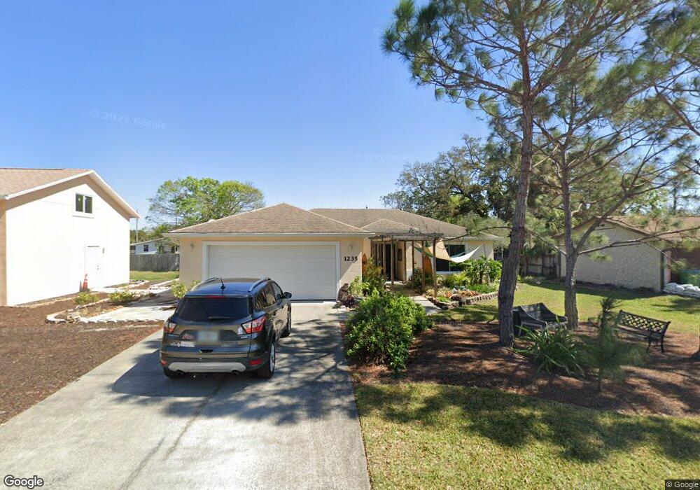
1235 Powers Ave Daytona Beach, FL 32117
Estimated Value: $255,000 - $287,000
3
Beds
2
Baths
1,483
Sq Ft
$184/Sq Ft
Est. Value
About This Home
This home is located at 1235 Powers Ave, Daytona Beach, FL 32117 and is currently estimated at $273,051, approximately $184 per square foot. 1235 Powers Ave is a home located in Volusia County with nearby schools including Holly Hill School, Mainland High School, and Open Bible Christian Academy.
Ownership History
Date
Name
Owned For
Owner Type
Purchase Details
Closed on
Feb 1, 2008
Sold by
Mckeown Robert C
Bought by
Woodriff Carol J
Current Estimated Value
Purchase Details
Closed on
Feb 23, 2006
Sold by
The Lighthouse For Christ Inc
Bought by
Mckeown Robert C
Purchase Details
Closed on
Aug 11, 2004
Sold by
Rawlins George Harvey and Rawlins Deliah
Bought by
The Lighthouse For Christ Inc
Purchase Details
Closed on
Jul 15, 1969
Bought by
Woodriff Carol J
Create a Home Valuation Report for This Property
The Home Valuation Report is an in-depth analysis detailing your home's value as well as a comparison with similar homes in the area
Home Values in the Area
Average Home Value in this Area
Purchase History
| Date | Buyer | Sale Price | Title Company |
|---|---|---|---|
| Woodriff Carol J | $189,000 | Columbia Title Research Corp | |
| Mckeown Robert C | $60,000 | Columbia Title Research Corp | |
| The Lighthouse For Christ Inc | -- | Southern Title Holding Compa | |
| Woodriff Carol J | $900 | -- |
Source: Public Records
Tax History Compared to Growth
Tax History
| Year | Tax Paid | Tax Assessment Tax Assessment Total Assessment is a certain percentage of the fair market value that is determined by local assessors to be the total taxable value of land and additions on the property. | Land | Improvement |
|---|---|---|---|---|
| 2025 | $4,208 | $333,548 | $31,623 | $301,925 |
| 2024 | $4,208 | $274,065 | $31,623 | $242,442 |
| 2023 | $4,208 | $264,958 | $28,217 | $236,741 |
| 2022 | $4,047 | $259,362 | $22,080 | $237,282 |
| 2021 | $3,699 | $203,653 | $17,112 | $186,541 |
| 2020 | $3,229 | $170,106 | $12,555 | $157,551 |
| 2019 | $2,985 | $161,955 | $12,555 | $149,400 |
| 2018 | $2,668 | $126,372 | $10,935 | $115,437 |
| 2017 | $2,602 | $117,921 | $8,505 | $109,416 |
| 2016 | $2,446 | $106,627 | $0 | $0 |
| 2015 | $2,408 | $100,289 | $0 | $0 |
| 2014 | $2,323 | $96,319 | $0 | $0 |
Source: Public Records
Map
Nearby Homes
- 1226 Bender Ave
- 1230 Graham Ave
- 1324 Powers Ave
- 610 Walker St
- 623 Unabelle Ave
- 624 Lpga Blvd Unit B
- 510 Lpga Blvd
- 1355 Powers Ave
- 1137 Cave Ave
- 638 Lpga Blvd Unit A
- 638 Lpga Blvd Unit B
- 644 Lpga Blvd Unit A
- 644 Lpga Blvd Unit B
- 1390 Powers Ave
- 1260 Charter Oaks Cir
- 1013 Indian Oaks E
- 1017 Chippewa Trail
- 600 10th St
- 1000 Walker St
- 1000 Walker St Unit 84
- 1229 Powers Ave
- 1236 Bender Ave
- 1243 Powers Ave
- 1240 Bender Ave
- 1230 Powers Ave
- 1220 Bender Ave
- 1225 Powers Ave
- 1242 Bender Ave
- 1224 Powers Ave
- 565 Walker St Unit 32117
- 558 Walker Ln
- 1216 Bender Ave
- 1218 Powers Ave
- 1211 Powers Ave
- 1231 Bender Ave
- 1233 Bender Ave
- 1229 Center Ave
- 1229 Center Ave Unit 2
- 1229 Center Ave
- 1210 Powers Ave