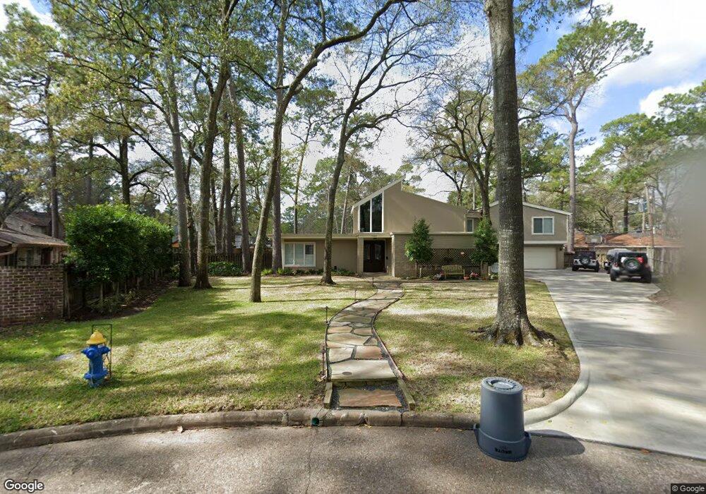
12351 Longworth Ln Houston, TX 77024
Memorial NeighborhoodEstimated Value: $1,443,000 - $1,721,709
5
Beds
5
Baths
4,154
Sq Ft
$383/Sq Ft
Est. Value
About This Home
This home is located at 12351 Longworth Ln, Houston, TX 77024 and is currently estimated at $1,592,677, approximately $383 per square foot. 12351 Longworth Ln is a home located in Harris County with nearby schools including Frostwood Elementary School, Memorial Middle, and Memorial High School.
Ownership History
Date
Name
Owned For
Owner Type
Purchase Details
Closed on
Jun 10, 2005
Sold by
Gibson Clyde M and Gibson Peggye Jane
Bought by
Dunn James L and Dunn Christine R
Current Estimated Value
Home Financials for this Owner
Home Financials are based on the most recent Mortgage that was taken out on this home.
Original Mortgage
$300,000
Outstanding Balance
$156,920
Interest Rate
5.79%
Mortgage Type
Fannie Mae Freddie Mac
Estimated Equity
$1,435,757
Create a Home Valuation Report for This Property
The Home Valuation Report is an in-depth analysis detailing your home's value as well as a comparison with similar homes in the area
Home Values in the Area
Average Home Value in this Area
Purchase History
| Date | Buyer | Sale Price | Title Company |
|---|---|---|---|
| Dunn James L | -- | Charter Title Company |
Source: Public Records
Mortgage History
| Date | Status | Borrower | Loan Amount |
|---|---|---|---|
| Open | Dunn James L | $300,000 |
Source: Public Records
Tax History Compared to Growth
Tax History
| Year | Tax Paid | Tax Assessment Tax Assessment Total Assessment is a certain percentage of the fair market value that is determined by local assessors to be the total taxable value of land and additions on the property. | Land | Improvement |
|---|---|---|---|---|
| 2025 | $25,491 | $1,607,872 | $988,033 | $619,839 |
| 2024 | $25,491 | $1,506,555 | $836,028 | $670,527 |
| 2023 | $25,491 | $1,485,970 | $836,028 | $649,942 |
| 2022 | $29,160 | $1,247,281 | $836,028 | $411,253 |
| 2021 | $29,150 | $1,215,239 | $836,028 | $379,211 |
| 2020 | $27,196 | $1,085,409 | $836,028 | $249,381 |
| 2019 | $31,102 | $1,189,868 | $836,028 | $353,840 |
| 2018 | $10,571 | $1,080,000 | $836,028 | $243,972 |
| 2017 | $28,254 | $1,080,000 | $836,028 | $243,972 |
| 2016 | $26,986 | $1,080,000 | $836,028 | $243,972 |
| 2015 | $17,943 | $1,190,000 | $836,028 | $353,972 |
| 2014 | $17,943 | $1,130,383 | $532,018 | $598,365 |
Source: Public Records
Map
Nearby Homes
- 354 Tealwood Dr
- 358 Tealwood Dr
- 12334 Beauregard Dr
- 336 Litchfield Ln
- 318 Litchfield Ln
- 271 Litchfield Ln
- 113 Memorial Parkview Dr
- 259 Litchfield Ln Unit 66
- 12327 Tunbridge Ln
- 53 Litchfield Ln
- 241 Litchfield Ln
- 201 Vanderpool Ln Unit 103
- 201 Vanderpool Ln Unit 65
- 201 Vanderpool Ln Unit 64
- 115 Litchfield Ln
- 203 Memorial Parkview Dr
- 206 Sutton Row Place
- 207 Sutton Row Place
- 201 Litchfield Ln
- 209 Sutton Row Place
- 12347 Longworth Ln
- 12355 Longworth Ln
- 346 Tamerlaine Dr
- 362 Tealwood Dr
- 342 Tamerlaine Dr
- 350 Tealwood Dr
- 12345 Longworth Ln
- 12359 Longworth Ln
- 366 Tealwood Dr
- 12339 Longworth Ln
- 346 Tealwood Dr
- 338 Tamerlaine Dr
- 370 Tealwood Dr
- 359 Tealwood Dr
- 355 Tealwood Dr
- 343 Tamerlaine Dr
- 12335 Longworth Ln
- 342 Tealwood Dr
- 363 Tealwood Dr
- 351 Tealwood Dr