Estimated Value: $111,525 - $321,000
Studio
--
Bath
--
Sq Ft
13,983
Sq Ft
About This Home
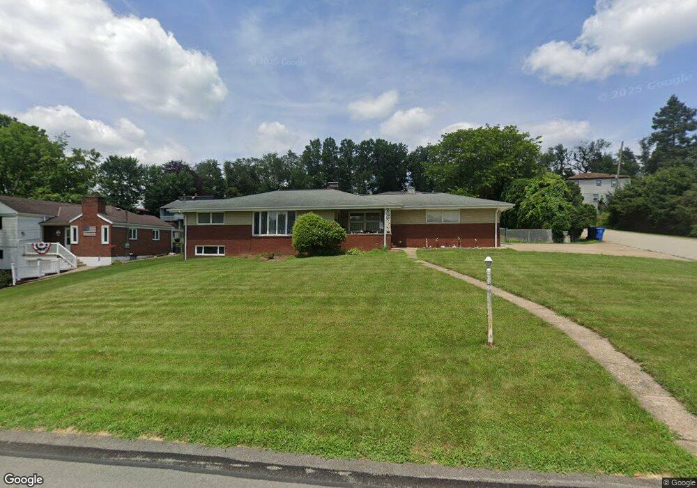
This home is located at 12359 Adams Dr, Irwin, PA 15642 and is currently estimated at $255,881. 12359 Adams Dr is a home located in Westmoreland County with nearby schools including Sunset Valley El School, Hillcrest Intermediate School, and Norwin Middle School.
Ownership History
Date
Name
Owned For
Owner Type
Purchase Details
Closed on
Jul 13, 2006
Sold by
Marks Darlene H and Vranich Diane V
Bought by
Long Donald S and Long Lois D
Current Estimated Value
Home Financials for this Owner
Home Financials are based on the most recent Mortgage that was taken out on this home.
Original Mortgage
$144,000
Outstanding Balance
$83,305
Interest Rate
6.67%
Mortgage Type
Unknown
Estimated Equity
$172,576
Create a Home Valuation Report for This Property
The Home Valuation Report is an in-depth analysis detailing your home's value as well as a comparison with similar homes in the area
Home Values in the Area
Average Home Value in this Area
Purchase History
| Date | Buyer | Sale Price | Title Company |
|---|---|---|---|
| Long Donald S | $180,000 | None Available |
Source: Public Records
Mortgage History
| Date | Status | Borrower | Loan Amount |
|---|---|---|---|
| Open | Long Donald S | $144,000 |
Source: Public Records
Tax History
| Year | Tax Paid | Tax Assessment Tax Assessment Total Assessment is a certain percentage of the fair market value that is determined by local assessors to be the total taxable value of land and additions on the property. | Land | Improvement |
|---|---|---|---|---|
| 2026 | $4,203 | $30,830 | $5,940 | $24,890 |
| 2025 | $4,059 | $30,830 | $5,940 | $24,890 |
| 2024 | $3,879 | $30,830 | $5,940 | $24,890 |
| 2023 | $3,664 | $30,830 | $5,940 | $24,890 |
| 2022 | $3,633 | $30,830 | $5,940 | $24,890 |
| 2021 | $3,633 | $30,830 | $5,940 | $24,890 |
| 2020 | $3,559 | $30,830 | $5,940 | $24,890 |
| 2019 | $3,470 | $30,830 | $5,940 | $24,890 |
| 2018 | $3,396 | $30,830 | $5,940 | $24,890 |
| 2017 | $3,322 | $30,830 | $5,940 | $24,890 |
| 2016 | $3,191 | $30,830 | $5,940 | $24,890 |
| 2015 | $3,191 | $30,830 | $5,940 | $24,890 |
| 2014 | $3,134 | $30,830 | $5,940 | $24,890 |
Source: Public Records
Map
Nearby Homes
- 12219 Roth Dr
- 12509 Herold Dr
- 12440 Saint Nikolai Dr
- 11911 North St
- 1521 Robbins Station Rd
- 1897 Haflinger Dr
- 12629 Deborah Dr
- 421 Robbins Station Rd
- 260 Jennie Dr
- 11639 Dartmoor Dr
- 11690 Center St
- 11561 Center St
- 160 Maus Dr
- 11490 Mckee Rd
- 0 Ridge Rd
- 3088 Derby Ct
- Parcel 3R Frank Wood Ridge Rd
- 11343 Seminole Dr
- 1051 Finchley Rd
- 1881 Craig Dr
- 12369 Adams Dr
- 12329 Adams Dr
- 12340 Herold Dr
- 12340 Adams Dr
- 12310 Herold Dr
- 12319 Adams Dr
- 12370 Adams Dr
- 12370 Herold Dr
- 12389 Adams Dr
- 12380 Adams Dr
- 12300 Herold Dr
- 12320 Adams Dr
- 12380 Herold Dr
- 12309 Adams Dr
- 12390 Adams Dr
- 12399 Adams Dr
- 12359 Roth Dr
- 12339 Herold Dr
- 12310 Adams Dr
- 12390 Herold Dr
Your Personal Tour Guide
Ask me questions while you tour the home.