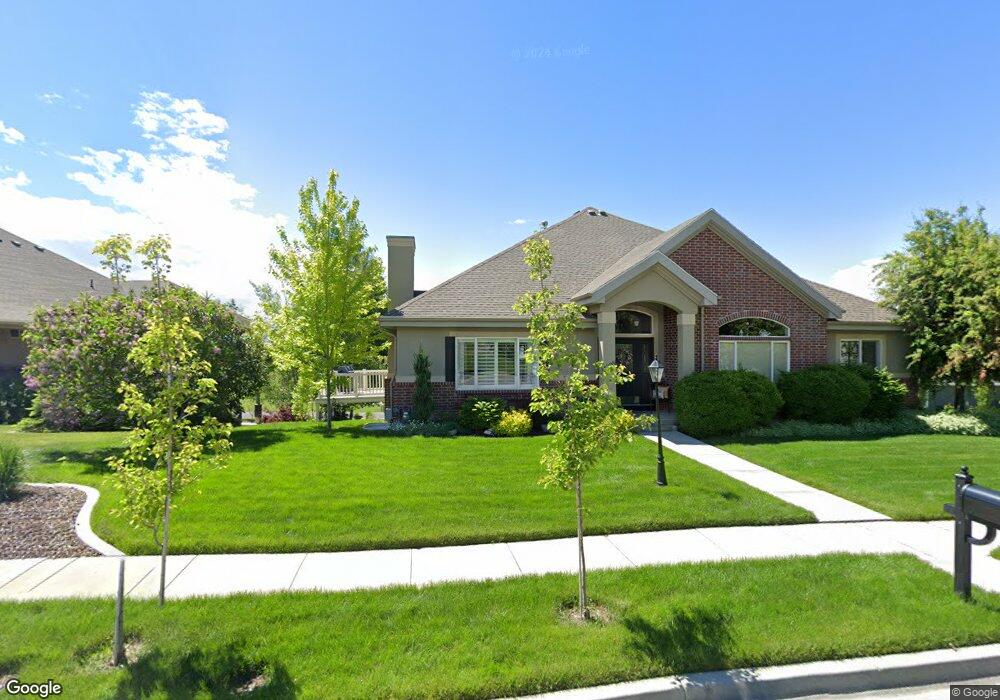
1236 E 650 N American Fork, UT 84003
Estimated Value: $551,000 - $572,000
3
Beds
3
Baths
2,874
Sq Ft
$196/Sq Ft
Est. Value
About This Home
This home is located at 1236 E 650 N, American Fork, UT 84003 and is currently estimated at $563,139, approximately $195 per square foot. 1236 E 650 N is a home located in Utah County with nearby schools including Barratt Elementary School, American Fork Junior High School, and American Fork High School.
Ownership History
Date
Name
Owned For
Owner Type
Purchase Details
Closed on
Jul 27, 2023
Sold by
Doris T Sweeten Living Trust
Bought by
Vineyard Place Llc
Current Estimated Value
Purchase Details
Closed on
Oct 13, 2005
Sold by
Sweeten Doris
Bought by
Sweeten Doris T
Purchase Details
Closed on
Apr 15, 2005
Sold by
Deutsche Bank National Trust Co
Bought by
Sweeten Doris
Purchase Details
Closed on
Feb 9, 2005
Sold by
Baldwin Gregory B
Bought by
Deutsche Bank National Trust Co
Purchase Details
Closed on
Nov 25, 2003
Sold by
Brown Duane E
Bought by
Baldwin Gregory B
Home Financials for this Owner
Home Financials are based on the most recent Mortgage that was taken out on this home.
Original Mortgage
$224,000
Interest Rate
7.42%
Mortgage Type
Purchase Money Mortgage
Create a Home Valuation Report for This Property
The Home Valuation Report is an in-depth analysis detailing your home's value as well as a comparison with similar homes in the area
Home Values in the Area
Average Home Value in this Area
Purchase History
| Date | Buyer | Sale Price | Title Company |
|---|---|---|---|
| Vineyard Place Llc | -- | Truly Title | |
| Sweeten Doris T | -- | -- | |
| Sweeten Doris | -- | United Title Services | |
| Deutsche Bank National Trust Co | $196,875 | Inwest Title Ogden | |
| Baldwin Gregory B | -- | First American Title Co |
Source: Public Records
Mortgage History
| Date | Status | Borrower | Loan Amount |
|---|---|---|---|
| Previous Owner | Baldwin Gregory B | $224,000 | |
| Closed | Baldwin Gregory B | $28,000 |
Source: Public Records
Tax History
| Year | Tax Paid | Tax Assessment Tax Assessment Total Assessment is a certain percentage of the fair market value that is determined by local assessors to be the total taxable value of land and additions on the property. | Land | Improvement |
|---|---|---|---|---|
| 2025 | $2,476 | $284,790 | -- | -- |
| 2024 | $2,476 | $275,165 | $0 | $0 |
| 2023 | $2,322 | $273,570 | $0 | $0 |
| 2022 | $806 | $264,770 | $0 | $0 |
| 2021 | $683 | $370,300 | $90,000 | $280,300 |
| 2020 | $664 | $349,300 | $90,000 | $259,300 |
| 2019 | $1,779 | $324,000 | $90,000 | $234,000 |
| 2018 | $596 | $315,600 | $90,000 | $225,600 |
| 2017 | $612 | $169,070 | $0 | $0 |
| 2016 | $492 | $139,975 | $0 | $0 |
| 2015 | $488 | $132,000 | $0 | $0 |
| 2014 | $1,470 | $120,175 | $0 | $0 |
Source: Public Records
Map
Nearby Homes
- 1121 E 580 N
- 467 N 1120 E
- 462 N 950 E Unit 5
- 1082 E 370 N
- 912 E Ellens St Unit 1
- 470 N 950 E Unit LOT 6
- 357 N 950 E
- 837 E 475 N
- 1045 N 930 E Unit 58
- 1125 N 1270 E
- 1077 N 950 E
- 1897 N 900 W
- 3518 N 1450 W
- 1427 Narra Place
- 410 N 600 E
- 472 W 2760 N
- 532 E 500 N
- 1365 N 990 W
- 674 W 1590 N Unit 11
- 1578 N 750 W Unit 15
- 1238 E 650 N
- 1242 E 650 N
- 1242 E 650 N Unit 147
- 1244 E 650 N
- 1244 E 650 N Unit 148
- 626 N 1200 E
- 626 N 1200 E Unit 29
- 1256 E 650 N
- 1256 Meadow View Ln
- 1213 E 650 N
- 618 N 1200 E Unit 30
- 618 N 1200 E
- 1237 E 650 N
- 1258 E 650 N
- 1249 E 650 N
- 1249 E 650 N Unit 26
- 1261 E 600 North Cir
- 1261 E 600 Cir N
- 1263 E 600 Cir N
- 1201 E 650 N
Your Personal Tour Guide
Ask me questions while you tour the home.