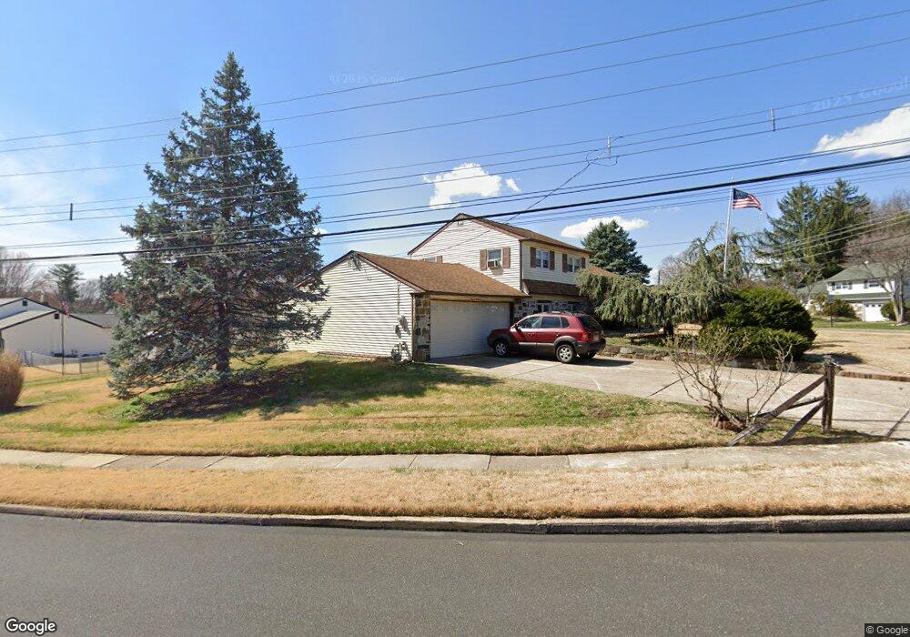
1236 Roberts Rd Warminster, PA 18974
Estimated Value: $426,904 - $495,000
3
Beds
2
Baths
960
Sq Ft
$471/Sq Ft
Est. Value
About This Home
This home is located at 1236 Roberts Rd, Warminster, PA 18974 and is currently estimated at $451,976, approximately $470 per square foot. 1236 Roberts Rd is a home located in Bucks County with nearby schools including McDonald Elementary School, Log College Middle School, and William Tennent High School.
Ownership History
Date
Name
Owned For
Owner Type
Purchase Details
Closed on
Aug 30, 2007
Sold by
Brown Paul H and Brown Juanita M
Bought by
Bond Patrick M and Bond Patricia J
Current Estimated Value
Home Financials for this Owner
Home Financials are based on the most recent Mortgage that was taken out on this home.
Original Mortgage
$256,000
Outstanding Balance
$162,745
Interest Rate
6.65%
Mortgage Type
Purchase Money Mortgage
Estimated Equity
$289,231
Purchase Details
Closed on
Oct 25, 1993
Bought by
Brown Paul H and Brown Juanita M
Create a Home Valuation Report for This Property
The Home Valuation Report is an in-depth analysis detailing your home's value as well as a comparison with similar homes in the area
Home Values in the Area
Average Home Value in this Area
Purchase History
| Date | Buyer | Sale Price | Title Company |
|---|---|---|---|
| Bond Patrick M | $320,000 | None Available | |
| Brown Paul H | $130,000 | -- |
Source: Public Records
Mortgage History
| Date | Status | Borrower | Loan Amount |
|---|---|---|---|
| Open | Bond Patrick M | $256,000 |
Source: Public Records
Tax History
| Year | Tax Paid | Tax Assessment Tax Assessment Total Assessment is a certain percentage of the fair market value that is determined by local assessors to be the total taxable value of land and additions on the property. | Land | Improvement |
|---|---|---|---|---|
| 2025 | $5,488 | $26,000 | $6,800 | $19,200 |
| 2024 | $5,488 | $26,000 | $6,800 | $19,200 |
| 2023 | $5,319 | $26,000 | $6,800 | $19,200 |
| 2022 | $5,205 | $26,000 | $6,800 | $19,200 |
| 2021 | $5,084 | $26,000 | $6,800 | $19,200 |
| 2020 | $5,012 | $26,000 | $6,800 | $19,200 |
| 2019 | $4,746 | $26,000 | $6,800 | $19,200 |
| 2018 | $4,633 | $26,000 | $6,800 | $19,200 |
| 2017 | $4,497 | $26,000 | $6,800 | $19,200 |
| 2016 | $4,497 | $26,000 | $6,800 | $19,200 |
| 2015 | $4,409 | $26,000 | $6,800 | $19,200 |
| 2014 | $4,409 | $26,000 | $6,800 | $19,200 |
Source: Public Records
Map
Nearby Homes
- 786 Boxwood Dr
- 202 Strawberry Ct Unit 249
- 403 Silver Oak Ct
- 992 Jamison St
- 841 Nathaniel Trail
- 854 Phillips Rd
- 1136 Maxwell Manor
- 909 Holden Ct
- 422 Brandywine Ct Unit YV422
- 1024 Gates Place
- 941 Hamilton Way
- 920 Nathaniel Trail
- 737 Tennyson Dr
- 745 Tennyson Dr
- 942 Stein Ct
- 2103 Knox Ct Unit 2103
- 632 Longfellow Ct
- 630 Whittier Dr
- 1167 W Bristol Rd
- 641 Whittier Dr
Your Personal Tour Guide
Ask me questions while you tour the home.