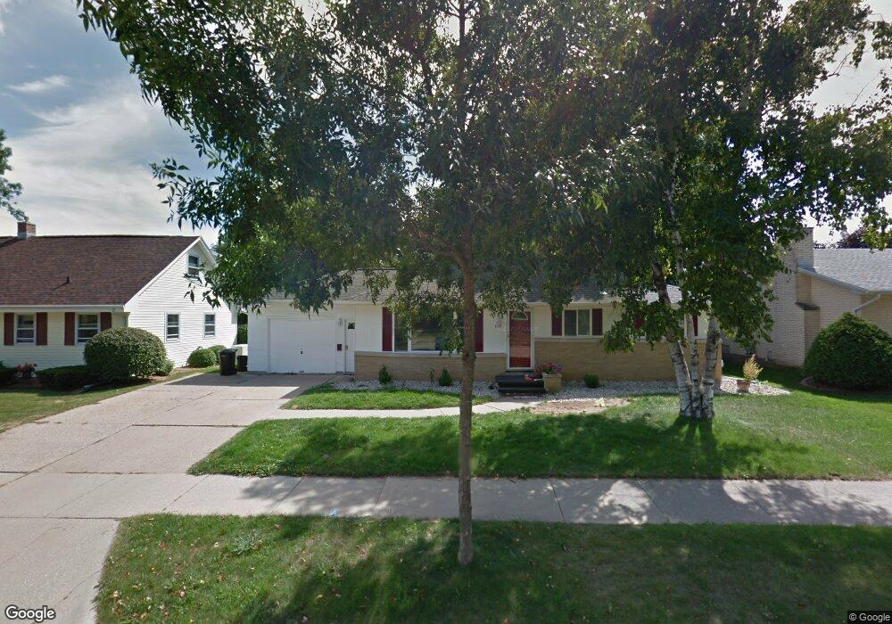
1237 E Pershing St Appleton, WI 54911
Huntley Houses NeighborhoodEstimated Value: $235,000 - $274,975
3
Beds
2
Baths
1,901
Sq Ft
$138/Sq Ft
Est. Value
About This Home
This home is located at 1237 E Pershing St, Appleton, WI 54911 and is currently estimated at $261,994, approximately $137 per square foot. 1237 E Pershing St is a home located in Outagamie County with nearby schools including Huntley Elementary School, Appleton North High School, and Classical School.
Ownership History
Date
Name
Owned For
Owner Type
Purchase Details
Closed on
Dec 22, 2025
Sold by
Hennessey Stacey L
Bought by
Vanhoof Edward J
Current Estimated Value
Purchase Details
Closed on
Aug 1, 2019
Sold by
Wiskow Gary A
Bought by
Hennessey Holdings Llc
Purchase Details
Closed on
Sep 16, 2011
Sold by
Rettler Michael J and Rettler Katie
Bought by
Wiskow Gary A
Purchase Details
Closed on
Oct 28, 2005
Sold by
Heuring Patrick A and Heuring Jenny L
Bought by
Rettler Michael J
Create a Home Valuation Report for This Property
The Home Valuation Report is an in-depth analysis detailing your home's value as well as a comparison with similar homes in the area
Home Values in the Area
Average Home Value in this Area
Purchase History
| Date | Buyer | Sale Price | Title Company |
|---|---|---|---|
| Vanhoof Edward J | -- | First American Title Insurance | |
| Hennessey Stacey L | -- | First American Title Insurance | |
| Hennessey Holdings Llc | $100,000 | -- | |
| Wiskow Gary A | $117,000 | -- | |
| Rettler Michael J | $117,000 | -- |
Source: Public Records
Tax History
| Year | Tax Paid | Tax Assessment Tax Assessment Total Assessment is a certain percentage of the fair market value that is determined by local assessors to be the total taxable value of land and additions on the property. | Land | Improvement |
|---|---|---|---|---|
| 2024 | $4,272 | $210,800 | $38,500 | $172,300 |
| 2023 | $3,367 | $210,800 | $38,500 | $172,300 |
| 2022 | $3,142 | $146,400 | $30,700 | $115,700 |
| 2021 | $3,008 | $146,400 | $30,700 | $115,700 |
| 2020 | $2,947 | $146,400 | $30,700 | $115,700 |
| 2019 | $2,882 | $146,400 | $30,700 | $115,700 |
| 2018 | $2,672 | $119,400 | $27,800 | $91,600 |
| 2017 | $2,623 | $119,400 | $27,800 | $91,600 |
| 2016 | $2,586 | $119,400 | $27,800 | $91,600 |
| 2015 | $3,614 | $119,400 | $27,800 | $91,600 |
| 2014 | $2,596 | $119,400 | $27,800 | $91,600 |
| 2013 | $2,601 | $119,400 | $27,800 | $91,600 |
Source: Public Records
Map
Nearby Homes
- 1011 E Lindbergh St
- 1437 E Glendale Ave
- 920 E Marquette St
- 1009 E Northwood Dr
- 1815 N Ullman St
- 921 E Windfield Place Unit A
- 1833 N Charlotte St
- 1809 N Charlotte St
- 841 E Windfield Place
- 2105 N Ballard Rd
- 1813 E Pauline St
- 701 E Longview Dr
- 2916 N Rankin St
- 1801 N Racine St
- 433 E Parkway Blvd
- 1430 N Graceland Ave
- 3401 N Fiesta Dr
- 8 Fiesta Ct Unit E
- 1426 N Meade St
- 507 E Roosevelt St
- 1229 E Pershing St
- 1301 E Pershing St
- 1311 E Pershing St
- 1307 E Pershing St
- 1236 E Pershing St
- 1230 E Pershing St
- 1308 E Lindbergh St
- 1302 E Lindbergh St
- 1236 E Lindbergh St
- 2509 Kirkland Ct
- 2509 N Kirkland Ct
- 1310 E Pershing St
- 2510 Hillwood Ct
- 1221 E Pershing St
- 1230 E Lindbergh St
- 2417 N Owaissa St
- 2510 Kirkland Ct
- 2517 Kirkland Ct
- 1222 E Pershing St
- 2516 Hillwood Ct
Your Personal Tour Guide
Ask me questions while you tour the home.