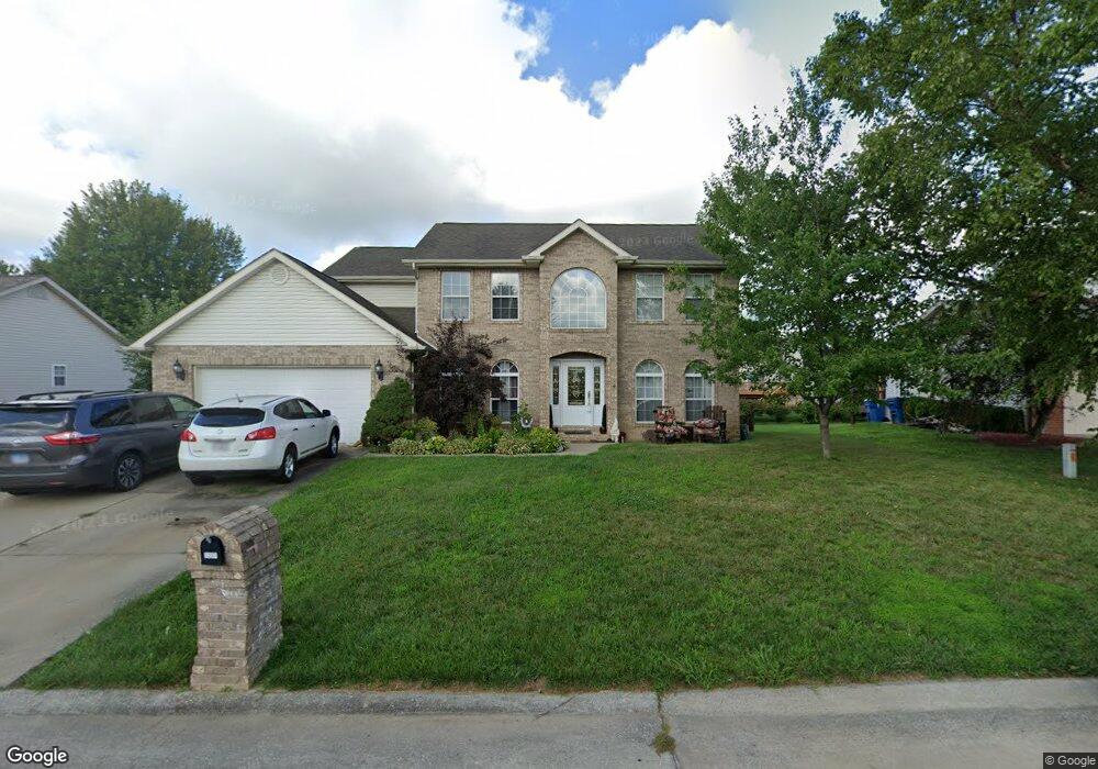
1237 Quail Ridge Ct Belleville, IL 62221
Estimated Value: $312,431 - $376,000
Studio
--
Bath
1,068
Sq Ft
$312/Sq Ft
Est. Value
About This Home
This home is located at 1237 Quail Ridge Ct, Belleville, IL 62221 and is currently estimated at $333,358, approximately $312 per square foot. 1237 Quail Ridge Ct is a home located in St. Clair County with nearby schools including Whiteside Elementary School, Whiteside Middle School, and Berean Christian School.
Ownership History
Date
Name
Owned For
Owner Type
Purchase Details
Closed on
Nov 16, 2001
Sold by
Meise Brothers Construction Co Inc
Bought by
Fann Richard and Fann Juanita
Current Estimated Value
Home Financials for this Owner
Home Financials are based on the most recent Mortgage that was taken out on this home.
Original Mortgage
$190,000
Outstanding Balance
$74,097
Interest Rate
6.69%
Mortgage Type
Purchase Money Mortgage
Estimated Equity
$259,261
Create a Home Valuation Report for This Property
The Home Valuation Report is an in-depth analysis detailing your home's value as well as a comparison with similar homes in the area
Home Values in the Area
Average Home Value in this Area
Purchase History
| Date | Buyer | Sale Price | Title Company |
|---|---|---|---|
| Fann Richard | $201,500 | Metro East Title Corp |
Source: Public Records
Mortgage History
| Date | Status | Borrower | Loan Amount |
|---|---|---|---|
| Open | Fann Richard | $190,000 |
Source: Public Records
Tax History
| Year | Tax Paid | Tax Assessment Tax Assessment Total Assessment is a certain percentage of the fair market value that is determined by local assessors to be the total taxable value of land and additions on the property. | Land | Improvement |
|---|---|---|---|---|
| 2024 | $5,954 | $92,416 | $14,570 | $77,846 |
| 2023 | $5,609 | $84,771 | $14,368 | $70,403 |
| 2022 | $4,881 | $77,205 | $13,086 | $64,119 |
| 2021 | $4,728 | $74,036 | $12,549 | $61,487 |
| 2020 | $4,597 | $68,949 | $11,687 | $57,262 |
| 2019 | $4,947 | $75,240 | $12,761 | $62,479 |
| 2018 | $4,857 | $73,319 | $12,435 | $60,884 |
| 2017 | $4,892 | $71,368 | $12,104 | $59,264 |
| 2016 | $4,868 | $68,908 | $11,687 | $57,221 |
| 2014 | $4,505 | $69,383 | $11,672 | $57,711 |
| 2013 | $4,976 | $69,383 | $11,672 | $57,711 |
Source: Public Records
Map
Nearby Homes
- 1219 Quail Ridge Ct
- 1214 Carleton Ln
- 1232 Carleton Ln
- 15 Sandpiper Dr
- 2271 Haverford Dr
- 517 E Waters Edge Dr
- 2562 Windsor Crest Ct
- 2609 Windsor Crest Ct
- 2605 Cheyenne Wells Dr
- 2645 Katrine Lake Dr
- 2609 Greystone Estates Pkwy
- 739 Oxen Dr
- 2728 Lauren Lake Dr
- 1304 Three Rivers Dr Unit 5B
- 1460 Hartman Ln
- 1301 Stone Hill Dr
- 804 Bluff Ridge Ln
- 2763 Cascade Lake Dr
- 2277 Wellington Dr
- 2611 Piper Hills Dr
- 1231 Quail Ridge Ct
- 1238 Pheasant Ridge Ct
- 1232 Pheasant Ridge Ct
- 1244 Pheasant Ridge Ct
- 1238 Quail Ridge Ct
- 1249 Quail Ridge Ct
- 1225 Quail Ridge Ct
- 1232 Quail Ridge Ct
- 1244 Quail Ridge Ct
- 1226 Pheasant Ridge Ct
- 1250 Pheasant Ridge Ct
- 1250 Quail Ridge Ct
- 1255 Quail Ridge Ct
- 2223 Mallard Bend Ct
- 1239 Fox Ridge Ct
- 1220 Pheasant Ridge Ct
- 1239 Pheasant Ridge Ct
- 2228 Mallard Bend Ct
- 1256 Pheasant Ridge Ct
- 1233 Pheasant Ridge Ct
Your Personal Tour Guide
Ask me questions while you tour the home.