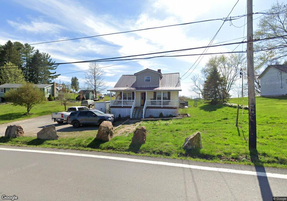
1237 River Rd Morgantown, WV 26501
Estimated Value: $151,752 - $218,000
4
Beds
2
Baths
1,092
Sq Ft
$160/Sq Ft
Est. Value
About This Home
This home is located at 1237 River Rd, Morgantown, WV 26501 and is currently estimated at $174,188, approximately $159 per square foot. 1237 River Rd is a home located in Monongalia County with nearby schools including Skyview Elementary School, Westwood Middle School, and University High School.
Ownership History
Date
Name
Owned For
Owner Type
Purchase Details
Closed on
Mar 12, 2020
Sold by
Cook Shawnda L
Bought by
Propertiesllc Carline
Current Estimated Value
Home Financials for this Owner
Home Financials are based on the most recent Mortgage that was taken out on this home.
Original Mortgage
$140,000
Outstanding Balance
$123,723
Interest Rate
3.5%
Mortgage Type
Commercial
Estimated Equity
$50,465
Purchase Details
Closed on
Nov 9, 2009
Sold by
Cook Gary L and Cook Linda S
Bought by
Cook Shawnda L
Home Financials for this Owner
Home Financials are based on the most recent Mortgage that was taken out on this home.
Original Mortgage
$91,301
Interest Rate
4.92%
Mortgage Type
Purchase Money Mortgage
Create a Home Valuation Report for This Property
The Home Valuation Report is an in-depth analysis detailing your home's value as well as a comparison with similar homes in the area
Home Values in the Area
Average Home Value in this Area
Purchase History
| Date | Buyer | Sale Price | Title Company |
|---|---|---|---|
| Propertiesllc Carline | $140,000 | None Available | |
| Cook Shawnda L | $65,000 | None Available |
Source: Public Records
Mortgage History
| Date | Status | Borrower | Loan Amount |
|---|---|---|---|
| Open | Propertiesllc Carline | $140,000 | |
| Previous Owner | Cook Shawnda L | $91,301 |
Source: Public Records
Tax History Compared to Growth
Tax History
| Year | Tax Paid | Tax Assessment Tax Assessment Total Assessment is a certain percentage of the fair market value that is determined by local assessors to be the total taxable value of land and additions on the property. | Land | Improvement |
|---|---|---|---|---|
| 2025 | $1,326 | $62,040 | $25,080 | $36,960 |
| 2024 | $1,326 | $62,040 | $25,080 | $36,960 |
| 2023 | $1,322 | $62,040 | $25,080 | $36,960 |
| 2022 | $1,110 | $54,180 | $17,880 | $36,300 |
| 2021 | $1,116 | $54,180 | $17,880 | $36,300 |
| 2020 | $560 | $54,180 | $17,880 | $36,300 |
| 2019 | $568 | $54,480 | $17,880 | $36,600 |
| 2018 | $569 | $54,480 | $17,880 | $36,600 |
| 2017 | $562 | $53,460 | $16,860 | $36,600 |
| 2016 | $511 | $48,360 | $16,860 | $31,500 |
| 2015 | $476 | $47,040 | $15,540 | $31,500 |
| 2014 | $437 | $45,300 | $14,220 | $31,080 |
Source: Public Records
Map
Nearby Homes
- 1021 Willis Dr
- 17 Brands Run Rd
- 316 Dye Ln
- TBD Master Graphics Rd
- 309 Dye Ln
- 322 Dye Ln
- 321 Dye Ln
- 330 Dye Ln
- 735 Hardman Dr
- 325 Dye Ln
- Penwell Plan at Woodside Ridge
- Galen Plan at Woodside Ridge
- Bristol Plan at Woodside Ridge
- Lafayette Plan at Woodside Ridge
- 329 Dye Ln
- 318 Dye Ln
- 715 Hardman Dr
- 723 Hardman Dr
- 315 Dye Ln
- 725 Hardman Dr
- 1229 River Rd
- 1251 River Rd
- 1214 River Rd
- 38 Price Hill Rd
- 2 Duvall Ln
- 15 Twilite Ln
- 37 Price Hill Rd
- 50 Price Hill Rd
- 1284 River Rd
- 1252 River Rd
- 58 Price Hill Rd
- 1218 River Rd
- 1256 River Rd
- 66 Price Hill Rd
- 1216 River Rd
- 63 Price Hill Rd
- 2 Saylor Rd
- 76 Price Hill Rd
- 61 Price Hill Rd
- 53 Price Hill Rd