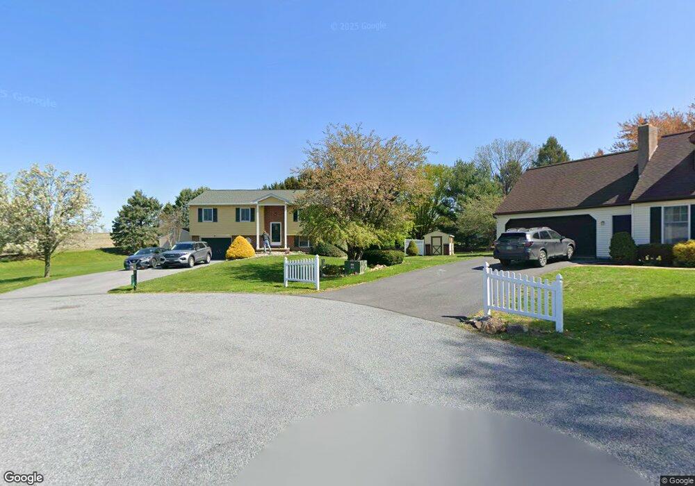
1237 Shetland Cir East Earl, PA 17519
Estimated Value: $324,000 - $388,000
3
Beds
2
Baths
1,024
Sq Ft
$337/Sq Ft
Est. Value
About This Home
This home is located at 1237 Shetland Cir, East Earl, PA 17519 and is currently estimated at $345,364, approximately $337 per square foot. 1237 Shetland Cir is a home located in Lancaster County with nearby schools including Garden Spot Middle School, Garden Spot Senior High School, and Conestoga Parochial School.
Ownership History
Date
Name
Owned For
Owner Type
Purchase Details
Closed on
Jun 17, 2005
Sold by
Kurtz Larry G and Kurtz Valerie A
Bought by
Anson John F and Anson Sandra Q
Current Estimated Value
Home Financials for this Owner
Home Financials are based on the most recent Mortgage that was taken out on this home.
Original Mortgage
$137,600
Outstanding Balance
$72,113
Interest Rate
5.82%
Mortgage Type
Fannie Mae Freddie Mac
Estimated Equity
$273,251
Purchase Details
Closed on
Oct 10, 2002
Sold by
Kurtz Larry G and Kurtz Doreen S
Bought by
Kurtz Larry G
Create a Home Valuation Report for This Property
The Home Valuation Report is an in-depth analysis detailing your home's value as well as a comparison with similar homes in the area
Home Values in the Area
Average Home Value in this Area
Purchase History
| Date | Buyer | Sale Price | Title Company |
|---|---|---|---|
| Anson John F | $172,000 | -- | |
| Kurtz Larry G | -- | -- |
Source: Public Records
Mortgage History
| Date | Status | Borrower | Loan Amount |
|---|---|---|---|
| Open | Anson John F | $137,600 |
Source: Public Records
Tax History Compared to Growth
Tax History
| Year | Tax Paid | Tax Assessment Tax Assessment Total Assessment is a certain percentage of the fair market value that is determined by local assessors to be the total taxable value of land and additions on the property. | Land | Improvement |
|---|---|---|---|---|
| 2025 | $2,814 | $157,100 | $51,600 | $105,500 |
| 2024 | $2,814 | $157,100 | $51,600 | $105,500 |
| 2023 | $2,773 | $157,100 | $51,600 | $105,500 |
| 2022 | $2,743 | $157,100 | $51,600 | $105,500 |
| 2021 | $2,699 | $157,100 | $51,600 | $105,500 |
| 2020 | $2,699 | $157,100 | $51,600 | $105,500 |
| 2019 | $2,670 | $157,100 | $51,600 | $105,500 |
| 2018 | $3,763 | $157,100 | $51,600 | $105,500 |
| 2017 | $2,501 | $120,100 | $34,900 | $85,200 |
| 2016 | $2,501 | $120,100 | $34,900 | $85,200 |
| 2015 | $695 | $120,100 | $34,900 | $85,200 |
| 2014 | $1,666 | $120,100 | $34,900 | $85,200 |
Source: Public Records
Map
Nearby Homes
- 1220 Shetland Cir
- 1215 Shetland Cir
- 1411 Martin St
- 1276 Martin St
- 1145 Brownstone Ridge
- 529 Ranck Rd Unit 6
- 529 Ranck Rd Unit 10
- 529 Ranck Rd Unit 9
- 529 Ranck Rd Unit 8
- 529 Ranck Rd Unit 5
- 529 Ranck Rd Unit 4
- 529 Ranck Rd Unit 3
- 529 Ranck Rd Unit 2
- 529 Ranck Rd Unit 1
- 13 Amber Cir
- 44 Emily Ln
- 404 Jared Way
- 300 Jared Way
- 113 Windsock Way
- 504 Jared Way
- 1238 Shetland Cir
- 1231 Shetland Cir
- 1305 Sheep Hill Rd
- 1232 Shetland Cir
- 1227 Shetland Cir
- 1293 Sheep Hill Rd
- 1289 Sheep Hill Rd
- 1297 Sheep Hill Rd
- 1283 Sheep Hill Rd
- 1301 Sheep Hill Rd
- 1223 Shetland Cir
- 1226 Shetland Cir
- 1281 Sheep Hill Rd
- 1298 Sheep Hill Rd
- 1290 Sheep Hill Rd
- 1219 Shetland Cir
- 1284 Sheep Hill Rd
- 1277 Sheep Hill Rd
- 1270 Springville Rd
- 1306 Sheep Hill Rd