$310,000
SOLD APR 24, 2025

12372 Owl Hollow Rd 15 5 Ac Rd West Fork, AR 72774

16 Acres
$19,987 Price per Acre
675,616 Sq Ft Lot

Recently Sold

30 Days on Market

Highlights

  • Waterfront
  • Views
  • Partially Fenced Property
  • 15.51 Acre Lot
  • Creek or Stream
  • Open Lot

About This Lot

As of April 2025

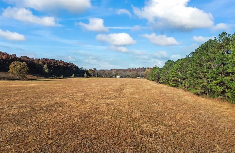
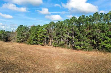
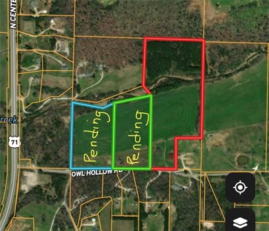
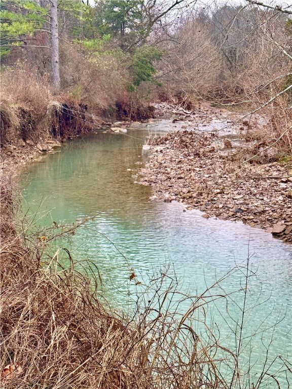
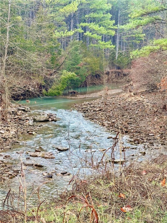
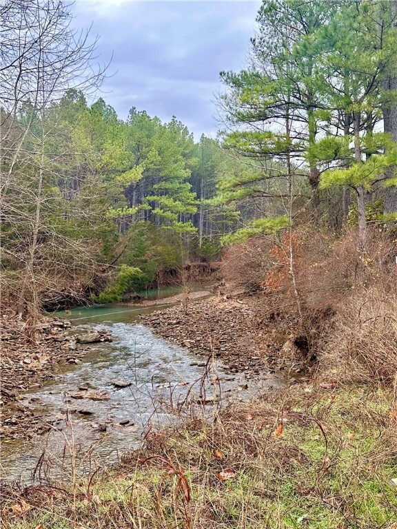
Incredibly beautiful land bordering Rock Creek only 10 minutes to downtown Fayetteville and U of A. Start a hobby farm or build an estate home on this incredible land. The creek runs through these acres. Who wouldn't want a creek in their back yard and still live this close to everything? No restrictive covenants. Subject to lot split. Barn is included in property, structure conveys "as is". Property listed multiple ways. See also MLS#'s 1294804, 1294824 & 1294830

Last Agent to Sell the Property

Tina Stanley

Arkansas Real Estate Group Fayetteville Brokerage Phone: 479-318-0433 License #SA00084039 Listed on: 12/28/2024

Last Buyer's Agent

Donald Ruble

Keller Williams Market Pro Realty License #SA00070018

Keller Williams Market Pro Realty

Property Details

Property Type

  • Land

Est. Annual Taxes

  • $52

Lot Details

  • 15.51 Acre Lot
  • Waterfront
  • Creek or Stream
  • Rural Setting
  • Partially Fenced Property
  • Open Lot
  • Cleared Lot

Location

  • Outside City Limits

Utilities

  • Water Tap or Transfer Fee
  • Septic Needed

Additional Features

  • Property Views

Property Details

Property Type

Land

Est. Annual Taxes

$52

Lot Details

0

Listing Details

  • Property Sub Type: Unimproved Land
  • Prop. Type: Land
  • Lot Size Acres: 15.51
  • Road Surface Type: Paved
  • Subdivision Name: no
  • Directions: From Fayetteville take hwy 71 South toward West Fork. Turn left onto Owl Hollow Road. Property is on the left. Look for sign.
  • ResoPropertyType: Land
  • Property Sub Type Additional: Unimproved Land
  • Attribution Contact: 479-318-0433
  • Special Features: VirtualTour

Exterior Features

  • Fencing: Partial
  • Lot Features: Cleared, Not In Subdivision, Outside City Limits, Open Lot, Rural Lot, Waterfront, Pond on Lot, Stream/Creek
  • View: Yes
  • Waterfront: Yes

Utilities

  • Sewer: Septic Needed
  • Water Source: Rural, Water Tap Fee

Condo/Co-op/Association

  • Association #2 Fee Frequency: Monthly

Schools

  • Junior High Dist: Greenland

Lot Info

  • ResoLotSizeUnits: Acres

Tax Info

  • Tax Annual Amount: 54.0
  • Tax Block: n/a
  • Tax Lot: n/a

Ownership History

Date Name Owned For Owner Type

Purchase Details

Closed on
Oct 18, 1991
Bought by
Baker Buford D and Baker Margaret
Total Days on Market
30

Purchase Details

Closed on
Jan 1, 1985
Bought by
Freriks Stanley and Freriks Connie
Source: Public Records

Similar Property in West Fork, AR

  • 13.32 acres Delgado Rd, West Fork, AR 72774

    $270,000

    • Land
    • 13 Acres
    • $20,270 per Acre
    • 13.32 acres Delgado Rd
    • West Fork, AR

    15 miles south of the University of Arkansas, 13+/- acres with incredible mountain top views! You can enjoy nature, peace and privacy in the Boston Mountains without sacrificing reasonable commute times. Multiple building sites w/soil test, notable outcroppings, beautiful native stone, and abundant wildlife. 19 miles to Devil's Den State Park. 17 miles to Lake Fork Smith State Park. Only 2 miles

    Angela Thompson Fathom Realty

    Section Image

Range of Values:

Collateral Analytics

Collateral Analytics Collateral Analytics AVMs (Automated Valuation Model) employ a number of statistical approaches combined with neighborhood-specific comparable selection guarantees the most up-to-date and precise valuations.

Not Available

Collateral Analytics does not have data for the current month. Please view the chart for historical values.

ICE

ICE Mortgage Technology ICE Mortgage Technology’s AVM (Automated Valuation Model) is a state-of-the-art online residential property valuation tool that provides a quick and accurate estimate of the value of almost any home in the U.S.

Not Available

ICE Mortgage Technology does not have data for the current month. Please view the chart for historical values.

First American

First American First American Data & Analytics’ next-generation AVM combines unrivaled data assets with a blended ensemble of valuation models to produce highly accurate, reliable valuations you can trust.

Not Available

First American does not have data for the current month. Please view the chart for historical values.

Quantarium

Quantarium Quantarium’s valuation service, repeatedly proven the industry’s most accurate and comprehensive, is supercharged with a self-learning and auto-tuning AI engine that continually becomes smarter and more accurate as it processes daily inputs from the industry’s leading RE data lake.

Not Available

Quantarium does not have data for the current month. Please view the chart for historical values.

Average Value
Not Available
List Price
Sold Price
Create a Home Valuation Report for This Property
The Home Valuation Report is an in-depth analysis detailing your home's value as well as a comparison with similar homes in the area

Home Values in the Area

Source: Public Records

Average Home Value in this Area


Source: Public Records

Purchase History

Date Type Sale Price Title Company
Warranty Deed $18,500 --
Warranty Deed -- --
Source: Public Records

Mortgage History

Date Status Loan Amount Loan Type
Open $250,750 Construction
Source: Public Records

Property History

Date Event Price Change Sq Ft Price
04/24/2025 04/24/25 Sold $310,000 -0.1% --
01/27/2025 01/27/25 Pending -- -- --
01/10/2025 01/10/25 Price Changed $310,200 +0.4% --
12/28/2024 12/28/24 For Sale $308,880 -- --
Source: Northwest Arkansas Board of REALTORS®

Tax History Compared to Growth

Source: Public Records

Tax History

Year Tax Paid Tax Assessment Tax Assessment Total Assessment is a certain percentage of the fair market value that is determined by local assessors to be the total taxable value of land and additions on the property. Land Improvement
2024 $52 $1,150 $970 $180
2023 $53 $1,150 $970 $180
2022 $54 $1,140 $960 $180
2021 $54 $1,140 $960 $180
2020 $54 $1,140 $960 $180
2019 $52 $1,100 $920 $180
2018 $52 $1,100 $920 $180
2017 $50 $1,100 $920 $180
2016 $52 $1,100 $920 $180
2015 $52 $1,100 $920 $180
2014 $50 $1,070 $840 $230
Source: Public Records

Agents Affiliated with this Home

  • Section Image
  • Section Image
See All Agents

Map

Source: Northwest Arkansas Board of REALTORS®

MLS Number: 1294819

Northwest Arkansas Board of REALTORS®

APN: 001-07163-000