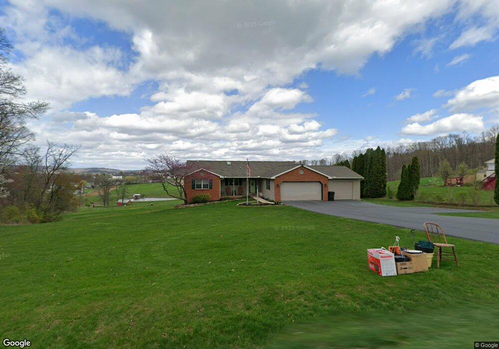
1238 Kramer Mill Rd Denver, PA 17517
Estimated Value: $377,000 - $488,000
3
Beds
3
Baths
1,344
Sq Ft
$326/Sq Ft
Est. Value
About This Home
This home is located at 1238 Kramer Mill Rd, Denver, PA 17517 and is currently estimated at $438,398, approximately $326 per square foot. 1238 Kramer Mill Rd is a home located in Lancaster County with nearby schools including Garden Spot Middle School, Garden Spot Senior High School, and Muddy Creek Christian School.
Ownership History
Date
Name
Owned For
Owner Type
Purchase Details
Closed on
Jul 20, 1999
Sold by
Snader Philip L
Bought by
Getz Philip D and Getz Shelley M
Current Estimated Value
Home Financials for this Owner
Home Financials are based on the most recent Mortgage that was taken out on this home.
Original Mortgage
$148,450
Outstanding Balance
$41,352
Interest Rate
7.49%
Estimated Equity
$397,046
Create a Home Valuation Report for This Property
The Home Valuation Report is an in-depth analysis detailing your home's value as well as a comparison with similar homes in the area
Home Values in the Area
Average Home Value in this Area
Purchase History
| Date | Buyer | Sale Price | Title Company |
|---|---|---|---|
| Getz Philip D | $164,947 | -- |
Source: Public Records
Mortgage History
| Date | Status | Borrower | Loan Amount |
|---|---|---|---|
| Open | Getz Philip D | $148,450 |
Source: Public Records
Tax History Compared to Growth
Tax History
| Year | Tax Paid | Tax Assessment Tax Assessment Total Assessment is a certain percentage of the fair market value that is determined by local assessors to be the total taxable value of land and additions on the property. | Land | Improvement |
|---|---|---|---|---|
| 2025 | $4,478 | $260,200 | $64,400 | $195,800 |
| 2024 | $4,478 | $260,200 | $64,400 | $195,800 |
| 2023 | $4,317 | $256,100 | $64,400 | $191,700 |
| 2022 | $4,243 | $256,100 | $64,400 | $191,700 |
| 2021 | $4,031 | $256,100 | $64,400 | $191,700 |
| 2020 | $4,031 | $256,100 | $64,400 | $191,700 |
| 2019 | $3,983 | $256,100 | $64,400 | $191,700 |
| 2018 | $6,216 | $256,100 | $64,400 | $191,700 |
| 2017 | $3,660 | $192,200 | $40,600 | $151,600 |
| 2016 | $3,660 | $192,200 | $40,600 | $151,600 |
| 2015 | $770 | $192,200 | $40,600 | $151,600 |
| 2014 | $2,670 | $189,700 | $40,600 | $149,100 |
Source: Public Records
Map
Nearby Homes
- 375 Lausch Rd
- 17 Sanderling Dr
- 13 Sanderling Dr
- 3 Whitetail Dr
- 27 Lausch Rd
- Westbrooke Plan at Hawk Valley Estates
- Callahan Plan at Hawk Valley Estates
- Silverbrooke Plan at Hawk Valley Estates
- Wesley Plan at Hawk Valley Estates
- Bridgemont Plan at Hawk Valley Estates
- Logan Plan at Hawk Valley Estates
- Brookfield Plan at Hawk Valley Estates
- Kingston Plan at Hawk Valley Estates
- Berkley Plan at Hawk Valley Estates
- Sullivan Plan at Hawk Valley Estates
- 44 S Muddy Creek Rd
- 82 Scenic Dr
- 17 W Kestrel Dr
- 117 Hawk Valley Ln Unit 105
- 346 Aplomado St
- 1234 Kramer Mill Rd
- 1243 Kramer Mill Rd
- 1230 Kramer Mill Rd
- 857 Lauschtown Rd
- 1226 Kramer Mill Rd
- 860 Lauschtown Rd
- 1222 Kramer Mill Rd
- 1218 Kramer Mill Rd
- 864 Lauschtown Rd
- 1257 Kramer Mill Rd
- 868 Lauschtown Rd
- 1272 Kramer Mill Rd
- 1274 Kramer Mill Rd
- 1212 Kramer Mill Rd
- 1276 Kramer Mill Rd
- 1280 Kramer Mill Rd
- 1206 Kramer Mill Rd
- 1282 Kramer Mill Rd
- 1283 Kramer Mill Rd
- 1281 Kramer Mill Rd