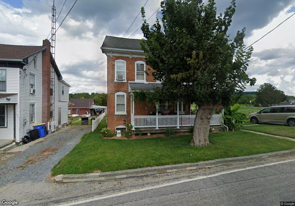
1239 Porters Rd Spring Grove, PA 17362
Estimated Value: $176,785 - $295,000
4
Beds
1
Bath
1,808
Sq Ft
$122/Sq Ft
Est. Value
About This Home
This home is located at 1239 Porters Rd, Spring Grove, PA 17362 and is currently estimated at $221,446, approximately $122 per square foot. 1239 Porters Rd is a home located in York County with nearby schools including Spring Grove Area Middle School, Spring Grove Area High School, and Garbers Mennonite School.
Ownership History
Date
Name
Owned For
Owner Type
Purchase Details
Closed on
Mar 25, 1998
Sold by
Pottorff Luther P and Pottorff Doris L
Bought by
Strayer Brenda A
Current Estimated Value
Purchase Details
Closed on
Dec 7, 1995
Bought by
Pottorff Luther P and Pottorff Doris L
Create a Home Valuation Report for This Property
The Home Valuation Report is an in-depth analysis detailing your home's value as well as a comparison with similar homes in the area
Home Values in the Area
Average Home Value in this Area
Purchase History
| Date | Buyer | Sale Price | Title Company |
|---|---|---|---|
| Strayer Brenda A | $48,600 | -- | |
| Pottorff Luther P | -- | -- |
Source: Public Records
Tax History Compared to Growth
Tax History
| Year | Tax Paid | Tax Assessment Tax Assessment Total Assessment is a certain percentage of the fair market value that is determined by local assessors to be the total taxable value of land and additions on the property. | Land | Improvement |
|---|---|---|---|---|
| 2025 | $3,320 | $98,810 | $26,730 | $72,080 |
| 2024 | $3,285 | $98,810 | $26,730 | $72,080 |
| 2023 | $3,285 | $98,810 | $26,730 | $72,080 |
| 2022 | $3,285 | $98,810 | $26,730 | $72,080 |
| 2021 | $3,144 | $98,810 | $26,730 | $72,080 |
| 2020 | $3,144 | $98,810 | $26,730 | $72,080 |
| 2019 | $3,077 | $98,810 | $26,730 | $72,080 |
| 2018 | $3,036 | $98,810 | $26,730 | $72,080 |
| 2017 | $2,942 | $98,810 | $26,730 | $72,080 |
| 2016 | -- | $98,810 | $26,730 | $72,080 |
| 2015 | $1,954 | $98,810 | $26,730 | $72,080 |
| 2014 | $1,954 | $98,810 | $26,730 | $72,080 |
Source: Public Records
Map
Nearby Homes
- 1063 Porters Rd
- 6428 York Rd
- 5931 York Rd
- 6475 Pamadeva Rd
- 5497 Stambaugh Rd
- 6306 Liam Dr
- 6309 Liam Dr
- 1323 Moulstown Rd N
- 6313 Liam Dr
- 6319 Liam Dr
- 6314 Liam Dr
- 6325 Liam Dr
- 0 Sassafras Plan at Hills at Valley View Unit PAYK2082018
- 6324 Liam
- 0 Sugar Maple Plan at Hills at Valley View Unit PAYK2082020
- 1495 Jefferson Rd
- 0 Pin Oak 5br Plan at Hills at Valley View Unit PAYK2087614
- 0 White Oak Plan at Hills at Valley View Unit PAYK2082080
- 0 Sweet Birch Plan at Hills at Valley View Unit PAYK2082022
- 0 Emily Plan at Hills at Valley View Unit PAYK2082076
- 1235 Porters Rd
- 1222 Porters Rd
- 1226 Porters Rd
- 1234 Porters Rd
- 1230 Porters Rd
- 1238 Porters Rd
- 1223 Porters Rd
- 1223 Porters Rd
- 6099 Carlton Ave
- 1242 Porters Rd
- 1246 Porters Rd
- 1219 Porters Rd
- 1215 Porters Rd
- 1250 Porters Rd
- 1209 Porters Rd
- 6063 Carlton Ave
- 6075 Carlton Ave
- 6106 Thoman Dr
- 1254 Porters Rd
- 6102 Thoman Dr