Estimated Value: $464,000 - $808,000
5
Beds
3
Baths
4,000
Sq Ft
$154/Sq Ft
Est. Value
About This Home
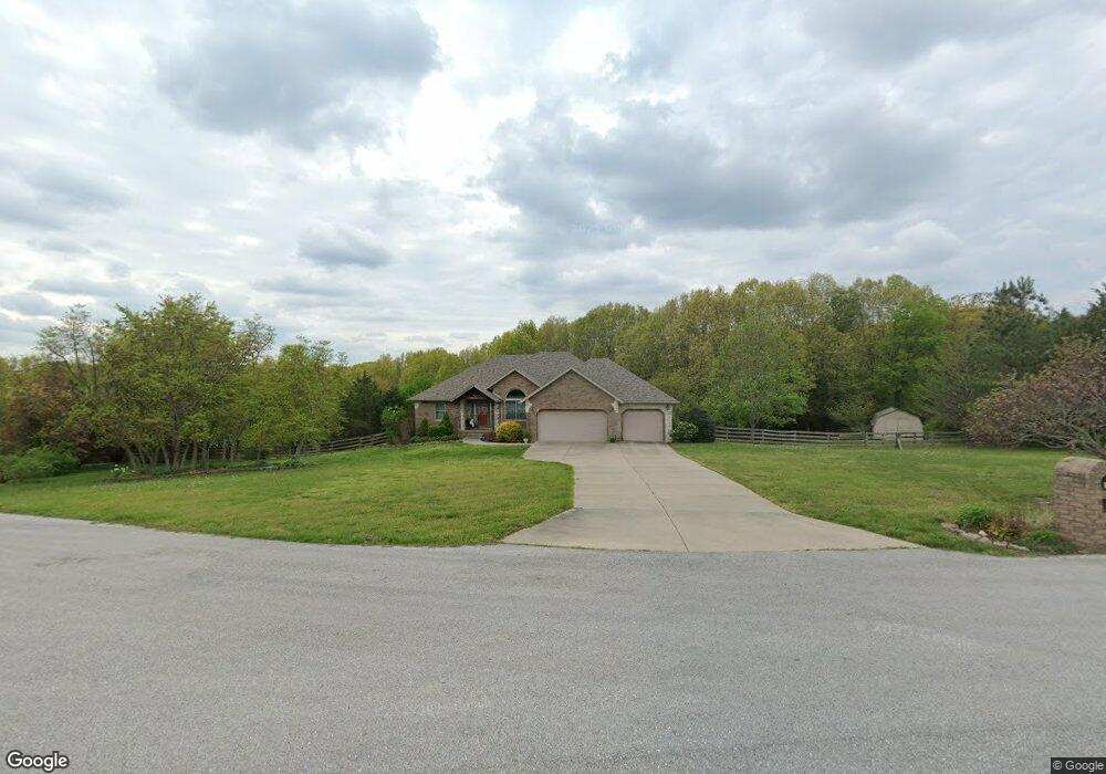
This home is located at 1239 S Tall Tree Way, Nixa, MO 65714 and is currently estimated at $617,384, approximately $154 per square foot. 1239 S Tall Tree Way is a home located in Christian County with nearby schools including Mathews Elementary School, Queens Gateway to Health Sciences Secondary School, and Nixa Junior High School.
Ownership History
Date
Name
Owned For
Owner Type
Purchase Details
Closed on
Feb 16, 2014
Sold by
Barr Roger and Barr Diane
Bought by
Barr Roger L and Diane E Barr Revocable Living Trust
Current Estimated Value
Purchase Details
Closed on
Mar 10, 2010
Sold by
Pettit Robb A
Bought by
Barr Roger and Barr Diane
Purchase Details
Closed on
Dec 29, 2004
Sold by
Lance Martin Construction Llc
Bought by
Pettit Robba A
Home Financials for this Owner
Home Financials are based on the most recent Mortgage that was taken out on this home.
Original Mortgage
$246,150
Interest Rate
7.5%
Mortgage Type
Adjustable Rate Mortgage/ARM
Create a Home Valuation Report for This Property
The Home Valuation Report is an in-depth analysis detailing your home's value as well as a comparison with similar homes in the area
Home Values in the Area
Average Home Value in this Area
Purchase History
| Date | Buyer | Sale Price | Title Company |
|---|---|---|---|
| Barr Roger L | -- | None Available | |
| Barr Roger | -- | Choice Escrow & Land Title L | |
| Pettit Robba A | -- | None Available |
Source: Public Records
Mortgage History
| Date | Status | Borrower | Loan Amount |
|---|---|---|---|
| Previous Owner | Pettit Robba A | $246,150 |
Source: Public Records
Tax History Compared to Growth
Tax History
| Year | Tax Paid | Tax Assessment Tax Assessment Total Assessment is a certain percentage of the fair market value that is determined by local assessors to be the total taxable value of land and additions on the property. | Land | Improvement |
|---|---|---|---|---|
| 2024 | $3,352 | $56,490 | -- | -- |
| 2023 | $3,352 | $56,490 | $0 | $0 |
| 2022 | $3,356 | $56,490 | $0 | $0 |
| 2021 | $3,358 | $56,490 | $0 | $0 |
| 2020 | $3,018 | $48,550 | $0 | $0 |
| 2019 | $3,018 | $48,550 | $0 | $0 |
| 2018 | $2,799 | $48,550 | $0 | $0 |
| 2017 | $2,799 | $48,550 | $0 | $0 |
| 2016 | $2,749 | $48,490 | $0 | $0 |
| 2015 | $2,752 | $48,490 | $48,490 | $0 |
| 2014 | $2,715 | $49,100 | $0 | $0 |
| 2013 | $2,719 | $49,100 | $0 | $0 |
| 2011 | -- | $98,200 | $0 | $0 |
Source: Public Records
Map
Nearby Homes
- Lot 9 Kelby Creek Phase 4
- Lot 5 Kelby Creek Phase 4
- Lot 21 Kelby Creek Phase 4
- Lot 10 Kelby Creek Phase 4
- Lot 14 Kelby Creek Phase 4
- Lot 19 Kelby Creek Phase 4
- Lot 8 Kelby Creek Phase 4
- Lot 16 Kelby Creek Phase 4
- Lot 18 Kelby Creek Phase 4
- Lot 6 Kelby Creek Phase 4
- Lot 11 Kelby Creek Phase 4
- Lot 3 Kelby Creek Phase 4
- Lot 12 Kelby Creek Phase 4
- Lot 17 Kelby Creek Phase 4
- Lot 13 Kelby Creek Phase 4
- Lot 20 Kelby Creek Phase 4
- Lot 7 Kelby Creek Phase 4
- Lot 1 Kelby Creek Phase 4
- 440 W White Ash Rd
- Lot 4 Kelby Creek Phase 4
- 1243 S Tall Tree Way
- 1227 S Tall Tree Way
- 1226 S Tall Tree Way
- 978 Cat Tail Ct
- 983 Cat Tail Ct
- 983 W Cat Tail Ct
- 850 W Rosedale Rd
- Lot 16 Kelby Creek Phase 6
- 1230 S Hickory Ln
- 991 W Cat Tail Ct
- 990 W Cat Tail Ct
- 1224 S Hickory Ln
- 1217 S Hickory Ln
- 900 W Rosedale Rd
- 900 Rosedale Rd
- 908 W Rosedale Rd
- 1031 W Cattail Ct
- 1225 S Hickory Ln
- 1004 Rosedale Rd
- 1211 S Hickory Ln