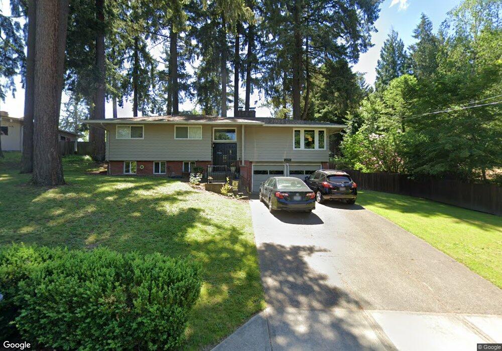
12390 SW Alberta St Portland, OR 97223
Derry Dell NeighborhoodEstimated Value: $618,000 - $716,000
3
Beds
3
Baths
2,172
Sq Ft
$310/Sq Ft
Est. Value
About This Home
This home is located at 12390 SW Alberta St, Portland, OR 97223 and is currently estimated at $674,026, approximately $310 per square foot. 12390 SW Alberta St is a home located in Washington County with nearby schools including Charles F. Tigard Elementary School, Thomas R. Fowler Middle School, and Tigard High School.
Ownership History
Date
Name
Owned For
Owner Type
Purchase Details
Closed on
Aug 30, 2024
Sold by
Daniels Brent and Brinson Maully
Bought by
Daniels Family Trust and Daniels
Current Estimated Value
Purchase Details
Closed on
Feb 29, 2016
Sold by
Turner Jeffrey Vern
Bought by
Maully Daniels Brent and Maully Brinson
Home Financials for this Owner
Home Financials are based on the most recent Mortgage that was taken out on this home.
Original Mortgage
$384,750
Interest Rate
3.92%
Mortgage Type
New Conventional
Create a Home Valuation Report for This Property
The Home Valuation Report is an in-depth analysis detailing your home's value as well as a comparison with similar homes in the area
Home Values in the Area
Average Home Value in this Area
Purchase History
| Date | Buyer | Sale Price | Title Company |
|---|---|---|---|
| Daniels Family Trust | -- | None Listed On Document | |
| Maully Daniels Brent | $412,000 | Fidelity Natl Title Co Of Or |
Source: Public Records
Mortgage History
| Date | Status | Borrower | Loan Amount |
|---|---|---|---|
| Previous Owner | Maully Daniels Brent | $384,750 |
Source: Public Records
Tax History Compared to Growth
Tax History
| Year | Tax Paid | Tax Assessment Tax Assessment Total Assessment is a certain percentage of the fair market value that is determined by local assessors to be the total taxable value of land and additions on the property. | Land | Improvement |
|---|---|---|---|---|
| 2025 | $6,086 | $356,960 | -- | -- |
| 2024 | $5,923 | $346,570 | -- | -- |
| 2023 | $5,923 | $336,480 | $0 | $0 |
| 2022 | $5,753 | $336,480 | $0 | $0 |
| 2021 | $5,608 | $317,170 | $0 | $0 |
| 2020 | $5,440 | $307,940 | $0 | $0 |
| 2019 | $5,204 | $298,980 | $0 | $0 |
| 2018 | $4,993 | $290,280 | $0 | $0 |
| 2017 | $4,813 | $281,830 | $0 | $0 |
| 2016 | $4,596 | $273,630 | $0 | $0 |
| 2015 | $3,869 | $232,670 | $0 | $0 |
| 2014 | $3,754 | $225,900 | $0 | $0 |
Source: Public Records
Map
Nearby Homes
- 13085 SW 124th Ave
- 12175 SW Alberta St
- 12249 SW Hollow Ln
- 12255 SW Tippitt Place
- 13154 SW 121st Ave
- 13236 SW Bigleaf Dr
- 12200 SW Walnut St
- 12174 SW Quail Creek Ln
- 0 SW Walnut St
- 13123 SW Merlin Place
- 12435 SW 121st Ave
- 12370 SW 121st Ave
- 13255 SW Kingston Place
- 12183 SW Plantation Terrace
- 12665 SW Karen St
- 13345 SW Kingston Place
- 13001 SW Gallin Ct
- 12557 SW 115th Ave
- 12822 SW Morningstar Dr
- 13728 SW 130th Place
- 12420 SW Alberta St
- 12360 SW Alberta St
- 12330 SW Alberta St
- 12385 SW Alberta St
- 12355 SW Alberta St
- 12325 SW Alberta St
- 12300 SW Alberta St
- 12325 SW James St
- 12295 SW Alberta St
- 12295 SW James St
- 12256 SW Lansdowne Ln
- 12355 SW James St
- 12275 SW James St
- 12270 SW Alberta St
- 12269 SW Broadleaf Terrace Unit Lot 5
- 12250 SW Lansdowne Ln
- 12840 SW Blue Heron Place
- 13125 SW 124th Ave
- 12850 SW Blue Heron Place
- 12245 SW Broadleaf Terrace Unit Lot 4