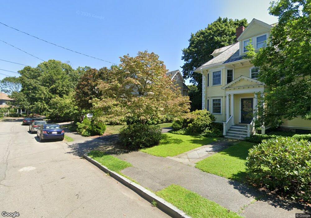
124 Allerton Rd Newton Highlands, MA 02461
Newton Highlands NeighborhoodEstimated Value: $2,180,524 - $2,506,000
6
Beds
4
Baths
2,578
Sq Ft
$893/Sq Ft
Est. Value
About This Home
This home is located at 124 Allerton Rd, Newton Highlands, MA 02461 and is currently estimated at $2,302,131, approximately $892 per square foot. 124 Allerton Rd is a home located in Middlesex County with nearby schools including Mason Rice Elementary School, Charles E Brown Middle School, and Newton South High School.
Ownership History
Date
Name
Owned For
Owner Type
Purchase Details
Closed on
Nov 12, 2002
Sold by
Doherty Charles J and Fox Dorothy
Bought by
Leonetti Kennet S and Amster Susan L
Current Estimated Value
Home Financials for this Owner
Home Financials are based on the most recent Mortgage that was taken out on this home.
Original Mortgage
$650,000
Outstanding Balance
$272,657
Interest Rate
6.04%
Mortgage Type
Purchase Money Mortgage
Estimated Equity
$2,029,474
Create a Home Valuation Report for This Property
The Home Valuation Report is an in-depth analysis detailing your home's value as well as a comparison with similar homes in the area
Home Values in the Area
Average Home Value in this Area
Purchase History
| Date | Buyer | Sale Price | Title Company |
|---|---|---|---|
| Leonetti Kennet S | $883,000 | -- |
Source: Public Records
Mortgage History
| Date | Status | Borrower | Loan Amount |
|---|---|---|---|
| Open | Leonetti Kennet S | $650,000 |
Source: Public Records
Tax History Compared to Growth
Tax History
| Year | Tax Paid | Tax Assessment Tax Assessment Total Assessment is a certain percentage of the fair market value that is determined by local assessors to be the total taxable value of land and additions on the property. | Land | Improvement |
|---|---|---|---|---|
| 2025 | $18,766 | $1,914,900 | $928,900 | $986,000 |
| 2024 | $18,145 | $1,859,100 | $901,800 | $957,300 |
| 2023 | $15,389 | $1,511,700 | $683,900 | $827,800 |
| 2022 | $14,725 | $1,399,700 | $633,200 | $766,500 |
| 2021 | $14,209 | $1,320,500 | $597,400 | $723,100 |
| 2020 | $13,786 | $1,320,500 | $597,400 | $723,100 |
| 2019 | $13,397 | $1,282,000 | $580,000 | $702,000 |
| 2018 | $12,829 | $1,185,700 | $524,600 | $661,100 |
| 2017 | $12,439 | $1,118,600 | $494,900 | $623,700 |
| 2016 | $11,897 | $1,045,400 | $462,500 | $582,900 |
| 2015 | $11,343 | $977,000 | $432,200 | $544,800 |
Source: Public Records
Map
Nearby Homes
- 1597 Centre St Unit 1597
- 1597 Centre St
- 1623-1625 Centre St
- 1629 Centre St
- 1151 Walnut St Unit 205
- 1151 Walnut St Unit 405
- 1151 Walnut St Unit 207
- 671 Boylston St
- 2 Raeburn Terrace
- 5 Halcyon Rd
- 125 Oakdale Rd
- 42 Sunhill Ln
- 956 Walnut St Unit 4
- 956 Walnut St Unit 7
- 956 Walnut St Unit 6
- 1292 Walnut St
- 1308 Walnut St
- 625 Boylston St
- 628 Boylston St
- 9 Ripley St Unit 1
- 118 Allerton Rd
- 128 Allerton Rd
- 1495 Centre St
- 1489 Centre St
- 1483 Centre St
- 121 Allerton Rd
- 138 Allerton Rd
- 119 Allerton Rd
- 127 Allerton Rd
- 1501 Centre St
- 115 Allerton Rd
- 1507 Centre St
- 146 Allerton Rd
- 1471 Centre St
- 137 Allerton Rd
- 109 Allerton Rd
- 1490 Centre St
- 1480 Centre St
- 1498 Centre St
- 1515 Centre St