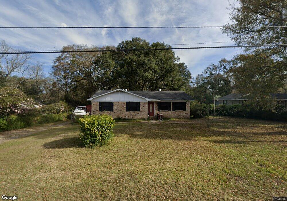
124 Bemis St Saraland, AL 36571
Estimated Value: $177,000 - $210,000
--
Bed
2
Baths
1,335
Sq Ft
$146/Sq Ft
Est. Value
About This Home
This home is located at 124 Bemis St, Saraland, AL 36571 and is currently estimated at $194,330, approximately $145 per square foot. 124 Bemis St is a home located in Mobile County with nearby schools including Saraland Elementary School, Nelson Leon Adams Middle School/Saraland Middle School, and Saraland High School.
Ownership History
Date
Name
Owned For
Owner Type
Purchase Details
Closed on
Jul 24, 2025
Sold by
Jalbert Joseph R
Bought by
Jalbert Joseph R and Jalbert Regina C
Current Estimated Value
Purchase Details
Closed on
Mar 13, 2008
Sold by
Davis Brian W and Davis Jessica M
Bought by
Jalbert Joseph R
Home Financials for this Owner
Home Financials are based on the most recent Mortgage that was taken out on this home.
Original Mortgage
$113,223
Interest Rate
5.68%
Mortgage Type
Purchase Money Mortgage
Purchase Details
Closed on
Dec 17, 2002
Sold by
Lott Betty Jean and Wilkins Irma E
Bought by
Davis Brian W and Davis Jessica M
Home Financials for this Owner
Home Financials are based on the most recent Mortgage that was taken out on this home.
Original Mortgage
$60,140
Interest Rate
6.07%
Create a Home Valuation Report for This Property
The Home Valuation Report is an in-depth analysis detailing your home's value as well as a comparison with similar homes in the area
Home Values in the Area
Average Home Value in this Area
Purchase History
| Date | Buyer | Sale Price | Title Company |
|---|---|---|---|
| Jalbert Joseph R | $66,500 | None Listed On Document | |
| Jalbert Joseph R | $115,000 | None Available | |
| Davis Brian W | -- | -- |
Source: Public Records
Mortgage History
| Date | Status | Borrower | Loan Amount |
|---|---|---|---|
| Previous Owner | Jalbert Joseph R | $113,223 | |
| Previous Owner | Davis Brian W | $60,140 |
Source: Public Records
Tax History Compared to Growth
Tax History
| Year | Tax Paid | Tax Assessment Tax Assessment Total Assessment is a certain percentage of the fair market value that is determined by local assessors to be the total taxable value of land and additions on the property. | Land | Improvement |
|---|---|---|---|---|
| 2024 | $684 | $12,610 | $3,000 | $9,610 |
| 2023 | $684 | $12,740 | $3,150 | $9,590 |
| 2022 | $647 | $11,980 | $2,810 | $9,170 |
| 2021 | $573 | $10,750 | $2,250 | $8,500 |
| 2020 | $524 | $9,940 | $1,880 | $8,060 |
| 2019 | $493 | $9,420 | $0 | $0 |
| 2018 | $551 | $10,380 | $0 | $0 |
| 2017 | $551 | $10,380 | $0 | $0 |
| 2016 | $568 | $10,680 | $0 | $0 |
| 2013 | $490 | $10,480 | $0 | $0 |
Source: Public Records
Map
Nearby Homes
- 30 Melinda Dr
- 129 Melinda Dr
- 205 Stauffer Ave
- 0 Shelton Beach Rd Unit 7618795
- 503 Shelton Beach Rd
- 20 Robbie Ln
- 0 Lincoln St
- 253 Autumn Dr
- 505 Norton Ave
- 159 Courtaulds Ave
- 234 Autumn Dr
- 410 Allen Cir
- 325 Bryant Ct
- 209 Kimberly Ct
- 832 Shelton Beach Rd
- 711 Ann St
- 21 Frances St
- 208 Strange Ave
- 0 Joaneen Dr Unit 7576451
- 804 Myron Ave