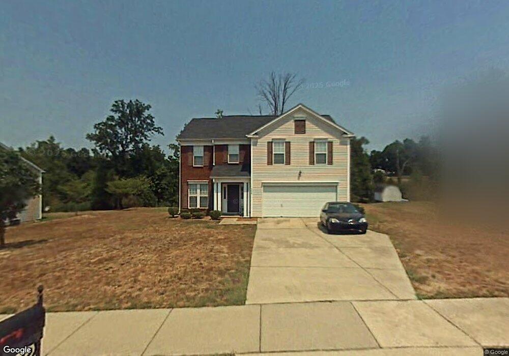
124 Brookstone Dr Mount Holly, NC 28120
Estimated Value: $360,337 - $387,000
3
Beds
2
Baths
2,071
Sq Ft
$183/Sq Ft
Est. Value
About This Home
This home is located at 124 Brookstone Dr, Mount Holly, NC 28120 and is currently estimated at $378,834, approximately $182 per square foot. 124 Brookstone Dr is a home located in Gaston County with nearby schools including Pinewood Elementary School, Mount Holly Middle School, and Stuart W. Cramer High School.
Ownership History
Date
Name
Owned For
Owner Type
Purchase Details
Closed on
Jun 6, 2008
Sold by
Martin Robert L
Bought by
Martin Betty Smith
Current Estimated Value
Home Financials for this Owner
Home Financials are based on the most recent Mortgage that was taken out on this home.
Original Mortgage
$152,554
Outstanding Balance
$97,492
Interest Rate
5.97%
Mortgage Type
FHA
Estimated Equity
$281,342
Purchase Details
Closed on
Jul 25, 2000
Sold by
Mulvaney Homes Inc
Bought by
Martin Robert L and Martin Betty Smith
Home Financials for this Owner
Home Financials are based on the most recent Mortgage that was taken out on this home.
Original Mortgage
$148,876
Interest Rate
8.3%
Mortgage Type
FHA
Create a Home Valuation Report for This Property
The Home Valuation Report is an in-depth analysis detailing your home's value as well as a comparison with similar homes in the area
Purchase History
| Date | Buyer | Sale Price | Title Company |
|---|---|---|---|
| Martin Betty Smith | -- | None Available | |
| Martin Robert L | $151,000 | -- |
Source: Public Records
Mortgage History
| Date | Status | Borrower | Loan Amount |
|---|---|---|---|
| Open | Martin Betty Smith | $152,554 | |
| Closed | Martin Robert L | $148,876 |
Source: Public Records
Tax History
| Year | Tax Paid | Tax Assessment Tax Assessment Total Assessment is a certain percentage of the fair market value that is determined by local assessors to be the total taxable value of land and additions on the property. | Land | Improvement |
|---|---|---|---|---|
| 2025 | $3,541 | $352,690 | $32,500 | $320,190 |
| 2024 | $3,541 | $352,690 | $32,500 | $320,190 |
| 2023 | $3,580 | $352,690 | $32,500 | $320,190 |
| 2022 | $2,617 | $202,100 | $25,000 | $177,100 |
| 2021 | $2,658 | $202,100 | $25,000 | $177,100 |
| 2019 | $2,678 | $202,100 | $25,000 | $177,100 |
| 2018 | $2,040 | $145,720 | $19,200 | $126,520 |
| 2017 | $2,040 | $145,720 | $19,200 | $126,520 |
| 2016 | $1,268 | $145,720 | $0 | $0 |
| 2014 | $1,341 | $154,116 | $28,000 | $126,116 |
Source: Public Records
Map
Nearby Homes
- 132 Sella Ridge Dr
- 112 N Woodcliff Ln
- 904 Timberlane Dr
- 000 Peach St
- 781 Woodlawn Ave
- 708 Noles Dr
- 605 Spring St
- 121 Morris Ave
- 108 Lassiter Ct
- 329 Crandon Rd
- 323 Crandon Rd
- 114 Old Mine Rd
- 112 N Canyon Ridge Dr
- 104 Deertrack Dr
- 504 Stone River Pkwy
- 331 Ox Bow Cir
- 109 Elk Ct
- 411 N Lee St
- 326 N Alexander St
- 401 N Lee St Unit C
- 120 Brookstone Dr
- 128 Brookstone Dr
- 116 Brookstone Dr
- 121 Brookstone Dr
- 117 Brookstone Dr
- 132 Brookstone Dr
- 125 Brookstone Dr
- 113 Brookstone Dr
- 112 Brookstone Dr
- 129 Brookstone Dr
- 109 Brookstone Dr
- 136 Brookstone Dr
- 136 Brookstone Dr Unit 65
- 113 Sella Ridge Dr
- 109 Sella Ridge Dr
- 117 Sella Ridge Dr
- 133 Brookstone Dr
- 121 Sella Ridge Dr
- 333 Lanier Ave
- 105 Sella Ridge Dr
Your Personal Tour Guide
Ask me questions while you tour the home.