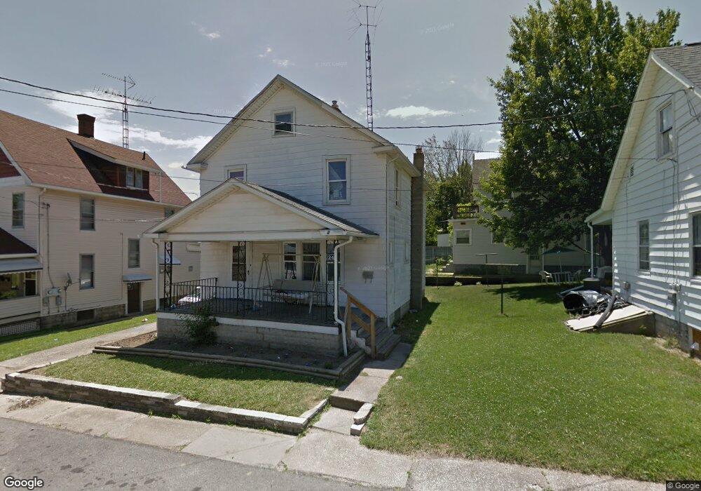
124 Flint St Mansfield, OH 44902
Estimated Value: $97,000 - $115,000
3
Beds
2
Baths
1,320
Sq Ft
$80/Sq Ft
Est. Value
About This Home
This home is located at 124 Flint St, Mansfield, OH 44902 and is currently estimated at $105,667, approximately $80 per square foot. 124 Flint St is a home located in Richland County with nearby schools including St. Peter's Elementary/Montessori School, Discovery School, and St. Peter's Junior High / High School.
Ownership History
Date
Name
Owned For
Owner Type
Purchase Details
Closed on
Jun 27, 2002
Sold by
Bankers Trust Co
Bought by
Willard Rental Properties
Current Estimated Value
Purchase Details
Closed on
Feb 6, 2002
Sold by
Shrf Richard Balliett Pr
Bought by
Bankers Trust Co Of Ca Na
Purchase Details
Closed on
Jul 14, 1998
Sold by
Sorensen Larry
Bought by
Balliett Richard W
Home Financials for this Owner
Home Financials are based on the most recent Mortgage that was taken out on this home.
Original Mortgage
$27,650
Interest Rate
7.17%
Mortgage Type
New Conventional
Create a Home Valuation Report for This Property
The Home Valuation Report is an in-depth analysis detailing your home's value as well as a comparison with similar homes in the area
Home Values in the Area
Average Home Value in this Area
Purchase History
| Date | Buyer | Sale Price | Title Company |
|---|---|---|---|
| Willard Rental Properties | $20,000 | -- | |
| Bankers Trust Co Of Ca Na | $20,000 | -- | |
| Balliett Richard W | $39,500 | -- |
Source: Public Records
Mortgage History
| Date | Status | Borrower | Loan Amount |
|---|---|---|---|
| Previous Owner | Balliett Richard W | $27,650 |
Source: Public Records
Tax History
| Year | Tax Paid | Tax Assessment Tax Assessment Total Assessment is a certain percentage of the fair market value that is determined by local assessors to be the total taxable value of land and additions on the property. | Land | Improvement |
|---|---|---|---|---|
| 2024 | $998 | $20,830 | $1,620 | $19,210 |
| 2023 | $997 | $20,830 | $1,620 | $19,210 |
| 2022 | $339 | $5,940 | $1,560 | $4,380 |
| 2021 | $342 | $5,940 | $1,560 | $4,380 |
| 2020 | $349 | $5,940 | $1,560 | $4,380 |
| 2019 | $329 | $5,040 | $1,320 | $3,720 |
| 2018 | $317 | $5,040 | $1,320 | $3,720 |
| 2017 | $287 | $5,040 | $1,320 | $3,720 |
| 2016 | $266 | $4,210 | $1,480 | $2,730 |
| 2015 | $809 | $13,420 | $1,480 | $11,940 |
| 2014 | $798 | $13,420 | $1,480 | $11,940 |
| 2012 | $609 | $13,430 | $1,560 | $11,870 |
Source: Public Records
Map
Nearby Homes
- 195 S Adams St
- 203 S Adams St
- 126 Flint St
- 205 S Adams St
- 202 Educational Place
- 187 S Adams St
- 125 Flint St
- 125 Flint St
- 206 Educational Place
- 129 Flint St
- 211 S Adams St
- 181 S Adams St
- 210 Educational Place
- 182 Educational Place
- 202 S Adams St
- 177 S Adams St
- 217 S Adams St
- 214 S Adams St
- 210 S Adams St
- 94 Flint St
Your Personal Tour Guide
Ask me questions while you tour the home.