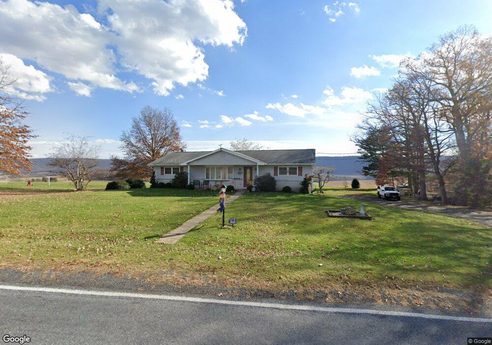
124 Ridge Rd Pitman, PA 17964
Estimated Value: $174,000 - $296,000
3
Beds
1
Bath
1,568
Sq Ft
$156/Sq Ft
Est. Value
About This Home
This home is located at 124 Ridge Rd, Pitman, PA 17964 and is currently estimated at $243,845, approximately $155 per square foot. 124 Ridge Rd is a home located in Schuylkill County with nearby schools including Tri-Valley Junior/Senior High School.
Ownership History
Date
Name
Owned For
Owner Type
Purchase Details
Closed on
May 17, 2019
Sold by
Neye Jean and Fetterholf Linda S
Bought by
Bomgardner Andrew Michael and Bomgardner Lydia Helen
Current Estimated Value
Home Financials for this Owner
Home Financials are based on the most recent Mortgage that was taken out on this home.
Original Mortgage
$150,000
Outstanding Balance
$131,342
Interest Rate
4%
Mortgage Type
New Conventional
Estimated Equity
$112,503
Purchase Details
Closed on
Jun 22, 2005
Sold by
Haas Robert and Haas Dorothy
Bought by
Neye Jean and Snyder Melissa
Create a Home Valuation Report for This Property
The Home Valuation Report is an in-depth analysis detailing your home's value as well as a comparison with similar homes in the area
Home Values in the Area
Average Home Value in this Area
Purchase History
| Date | Buyer | Sale Price | Title Company |
|---|---|---|---|
| Bomgardner Andrew Michael | $170,000 | Penn National Abstract Svcs | |
| Neye Jean | -- | None Available |
Source: Public Records
Mortgage History
| Date | Status | Borrower | Loan Amount |
|---|---|---|---|
| Open | Bomgardner Andrew Michael | $150,000 |
Source: Public Records
Tax History Compared to Growth
Tax History
| Year | Tax Paid | Tax Assessment Tax Assessment Total Assessment is a certain percentage of the fair market value that is determined by local assessors to be the total taxable value of land and additions on the property. | Land | Improvement |
|---|---|---|---|---|
| 2025 | $2,412 | $36,735 | $8,865 | $27,870 |
| 2024 | $2,110 | $36,735 | $8,865 | $27,870 |
| 2023 | $2,030 | $36,735 | $8,865 | $27,870 |
| 2022 | $1,968 | $36,735 | $8,865 | $27,870 |
| 2021 | $1,937 | $36,735 | $8,865 | $27,870 |
| 2020 | $1,937 | $36,735 | $8,865 | $27,870 |
| 2018 | $1,859 | $36,735 | $8,865 | $27,870 |
| 2017 | $1,783 | $36,735 | $8,865 | $27,870 |
| 2015 | -- | $36,735 | $8,865 | $27,870 |
| 2011 | -- | $36,735 | $0 | $0 |
Source: Public Records
Map
Nearby Homes
- 616 W Maple St
- 207 W Maple St
- 15 Snyder Rd
- 301 W Walnut St
- 4664 Upper Rd
- 421 Broad St
- 4617 Upper Rd
- 513 E Chestnut St
- 3183 Upper Rd
- 511 Pine Dr
- 537 E Chestnut St
- 4133 Lower Rd
- LOT#2 Blacks Ln
- LOT# 3 Blacks Ln
- 722 E Mountain Rd
- 1348 E Main St
- 533 S Market St
- 456 S Shamokin St
- 1530 W Fern St
- 135 W Montgomery St