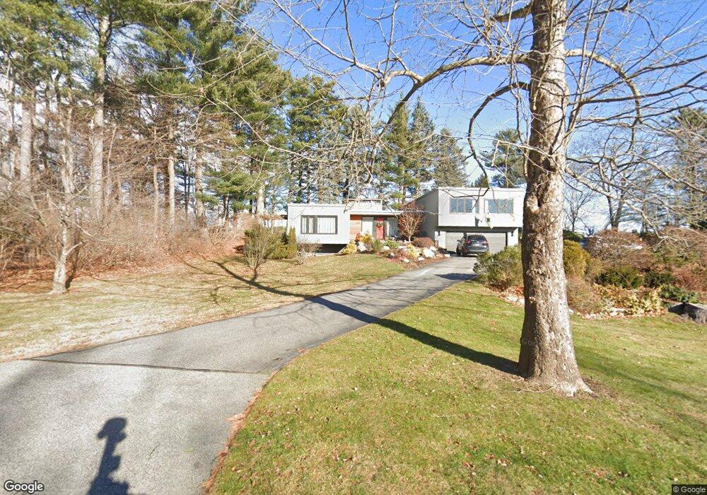
124 Stroudwater Rd Portland, ME 04102
Stroudwater NeighborhoodEstimated Value: $1,001,000 - $1,033,673
4
Beds
4
Baths
3,076
Sq Ft
$331/Sq Ft
Est. Value
About This Home
This home is located at 124 Stroudwater Rd, Portland, ME 04102 and is currently estimated at $1,017,418, approximately $330 per square foot. 124 Stroudwater Rd is a home located in Cumberland County with nearby schools including Amanda C Rowe School, King Middle School, and Levey Day School.
Ownership History
Date
Name
Owned For
Owner Type
Purchase Details
Closed on
Mar 17, 2015
Sold by
Carvel Frances B Est
Bought by
Archibald Michael G and Dionne Jason R
Current Estimated Value
Home Financials for this Owner
Home Financials are based on the most recent Mortgage that was taken out on this home.
Original Mortgage
$332,000
Outstanding Balance
$254,185
Interest Rate
3.67%
Mortgage Type
New Conventional
Estimated Equity
$763,233
Create a Home Valuation Report for This Property
The Home Valuation Report is an in-depth analysis detailing your home's value as well as a comparison with similar homes in the area
Home Values in the Area
Average Home Value in this Area
Purchase History
| Date | Buyer | Sale Price | Title Company |
|---|---|---|---|
| Archibald Michael G | -- | -- |
Source: Public Records
Mortgage History
| Date | Status | Borrower | Loan Amount |
|---|---|---|---|
| Open | Archibald Michael G | $332,000 |
Source: Public Records
Tax History Compared to Growth
Tax History
| Year | Tax Paid | Tax Assessment Tax Assessment Total Assessment is a certain percentage of the fair market value that is determined by local assessors to be the total taxable value of land and additions on the property. | Land | Improvement |
|---|---|---|---|---|
| 2024 | $9,681 | $645,000 | $96,700 | $548,300 |
| 2023 | $9,294 | $645,000 | $96,700 | $548,300 |
| 2022 | $8,778 | $645,000 | $96,700 | $548,300 |
| 2021 | $8,379 | $645,000 | $96,700 | $548,300 |
| 2020 | $8,189 | $351,300 | $92,000 | $259,300 |
| 2019 | $8,189 | $351,300 | $92,000 | $259,300 |
| 2018 | $7,897 | $351,300 | $92,000 | $259,300 |
| 2017 | $7,606 | $351,300 | $92,000 | $259,300 |
| 2016 | $7,080 | $335,400 | $92,000 | $243,400 |
| 2015 | $6,919 | $335,400 | $92,000 | $243,400 |
| 2014 | $6,708 | $335,400 | $92,000 | $243,400 |
Source: Public Records
Map
Nearby Homes
- 1346 Westbrook St
- 63A Capisic St
- 159 Bancroft St
- 1549 Westbrook St
- 1542 Congress St
- 16 Black Sparrow Dr
- 2 Firefly St Unit 303
- 1 Firefly St Unit 402
- 1 Firefly St Unit 201
- 1 Firefly St Unit 303
- 1 Firefly St Unit 302
- 1 Firefly St Unit 403/103
- 1 Firefly St Unit 301
- 1 Firefly St Unit 401
- 1 Firefly St Unit 403
- 1 Firefly St Unit 202
- 0 Hillcrest Ave
- 89 Cobb Ave
- 99 Webb St
- 7 Twin Knolls Ln
- 114 Stroudwater Rd
- 126 Stroudwater Rd
- 125 Stroudwater Rd
- 110 Stroudwater Rd
- 107 Stroudwater Rd
- 99 Stroudwater Rd
- 96 Stroudwater Rd
- 138 Stroudwater Rd
- 79 Stroudwater Rd
- 71 Stroudwater Rd
- 80 Stroudwater Rd
- 63 Stroudwater Rd
- 54 Penrith Rd
- 47 Roundabout Ln
- 55 Stroudwater Rd
- 55 Penrith Rd
- 48 Penrith Rd
- 54 Stroudwater Rd
- 72 Stroudwater Rd
- 35 Roundabout Ln