
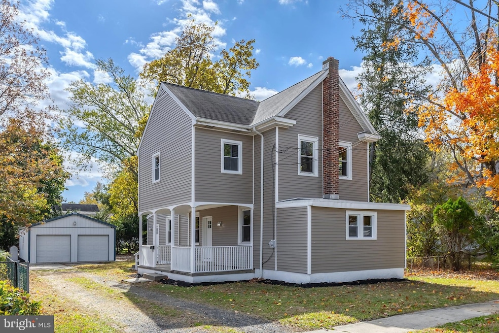

124 W Howard St Clayton, NJ 08312
Estimated payment $2,125/month
Total Views
49,387
3
Beds
1.5
Baths
1,492
Sq Ft
$218
Price per Sq Ft
Highlights
- Hot Property
- No HOA
- More Than Two Accessible Exits
- Victorian Architecture
- 2 Car Detached Garage
- Ceramic Tile Flooring
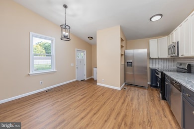
About This Home
Charming, Updated Home with Detached 30x30 Pole Barn in Beautiful Clayton, NJ!
Welcome to this tastefully updated home located in the heart of Clayton, NJ, where small-town charm meets modern comfort. Set in a friendly community known for its welcoming atmosphere, this move-in-ready property combines classic character with stylish upgrades throughout.
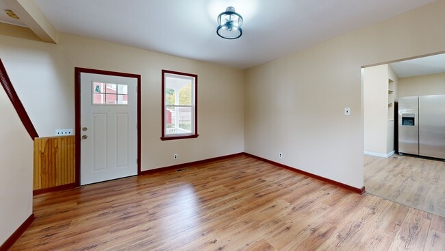
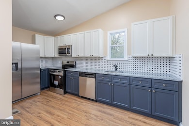
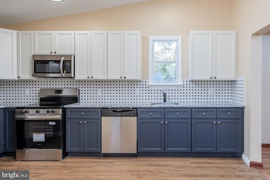
The home features brand-new siding and a Newly Renovated Kitchen with two-tone cabinetry, granite countertops, a ceramic tile backsplash, and a stainless steel appliance package. The spacious eat-in kitchen with Breakfast Room is perfect for everyday dining and entertaining alike, while the adjacent mudroom/laundry area—complete with a separate side entry—adds convenience and functionality.
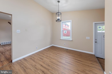
From the side entry porch, step into a thoughtfully arranged main level that is flexible & includes a bright living room, formal dining room (or Living Room & Family Room!), and an updated powder room. An enclosed front porch provides a flexible space ideal for a home office, reading nook, or sitting room—a perfect blend of charm and practicality.
Upstairs, you’ll find a generously sized primary bedroom, two additional bedrooms, and a custom full bath featuring a large walk-in shower. The walk-up attic offers excellent storage space or the potential to create an additional bedroom or bonus room. A small basement houses the home’s mechanicals and provides extra storage.
Car enthusiasts, hobbyists, or those needing workspace will appreciate the 30' x 30' detached pole barn garage, complete with two overhead doors and room for multiple vehicles or equipment.
With its modern updates, flexible living spaces, and quintessential small-town setting, this home offers the perfect balance of character and contemporary comfort. Buyer to pay transfer tax.
Listing Agent
(610) 220-9452 dtuna42@comcast.net Keller Williams Hometown License #1222774 Listed on: 10/23/2025
Home Details
Home Type
- Single Family
Est. Annual Taxes
- $4,963
Year Built
- Built in 1900 | Remodeled in 2025
Lot Details
- 10,049 Sq Ft Lot
- Lot Dimensions are 67.00 x 150.00
- Property is in excellent condition
Parking
- 2 Car Detached Garage
- Front Facing Garage
- Driveway
Home Design
- Victorian Architecture
- Stone Foundation
- Slab Foundation
- Shingle Roof
- Vinyl Siding
Interior Spaces
- 1,492 Sq Ft Home
- Property has 2 Levels
- Unfinished Basement
Flooring
- Carpet
- Laminate
- Ceramic Tile
Bedrooms and Bathrooms
- 3 Bedrooms
Accessible Home Design
- More Than Two Accessible Exits
Schools
- Herma S. Simmons Elementary School
- Clayton Middle School
- Clayton High School
Utilities
- Central Heating and Cooling System
- 120/240V
- 100 Amp Service
- Natural Gas Water Heater
- Municipal Trash
Community Details
- No Home Owners Association
Listing and Financial Details
- Tax Lot 00004
- Assessor Parcel Number 01-01402-00004
Matterport 3D Tour
Floorplans
Map
Create a Home Valuation Report for This Property
The Home Valuation Report is an in-depth analysis detailing your home's value as well as a comparison with similar homes in the area
Home Values in the Area
Average Home Value in this Area
Tax History
| Year | Tax Paid | Tax Assessment Tax Assessment Total Assessment is a certain percentage of the fair market value that is determined by local assessors to be the total taxable value of land and additions on the property. | Land | Improvement |
|---|---|---|---|---|
| 2025 | $4,782 | $193,200 | $72,700 | $120,500 |
| 2024 | $5,120 | $193,200 | $72,700 | $120,500 |
| 2023 | $5,120 | $126,700 | $31,600 | $95,100 |
| 2022 | $5,064 | $126,700 | $31,600 | $95,100 |
| 2021 | $5,003 | $126,700 | $31,600 | $95,100 |
| 2020 | $5,014 | $126,700 | $31,600 | $95,100 |
| 2019 | $4,929 | $126,700 | $31,600 | $95,100 |
| 2018 | $4,859 | $126,700 | $31,600 | $95,100 |
| 2017 | $4,777 | $126,700 | $31,600 | $95,100 |
| 2016 | $4,726 | $126,700 | $31,600 | $95,100 |
| 2015 | $4,587 | $122,700 | $31,600 | $91,100 |
| 2014 | $4,287 | $122,700 | $31,600 | $91,100 |
Source: Public Records
Property History
| Date | Event | Price | List to Sale | Price per Sq Ft |
|---|---|---|---|---|
| 11/21/2025 11/21/25 | Price Changed | $325,000 | -3.0% | $218 / Sq Ft |
| 10/23/2025 10/23/25 | For Sale | $335,000 | -- | $225 / Sq Ft |
Source: Bright MLS
Purchase History
| Date | Type | Sale Price | Title Company |
|---|---|---|---|
| Deed | $162,500 | None Listed On Document | |
| Deed | $162,500 | None Listed On Document | |
| Deed | $81,000 | Congress Title Corp | |
| Deed | $25,100 | -- |
Source: Public Records
Mortgage History
| Date | Status | Loan Amount | Loan Type |
|---|---|---|---|
| Open | $211,300 | Construction | |
| Closed | $211,300 | Construction |
Source: Public Records
About the Listing Agent
Member: National, NJ, & Gloucester-Salem, & Burlington-Camden County Boards of Realtors
GSBOR 2018 Don Brogan Peer Appreciation Award
NJAR Circle of Excellence, 2013 - 2020
Philadelphia Magazine "Five Star Agent"2015-2021
"Best of Swedesboro" 2015-2018
*Accredited Buyer's Representative (ABR)
*Short-sale & Foreclosure Resource (SFR)
David's Other Listings
Source: Bright MLS
MLS Number: NJGL2065578
APN: 01-01402-0000-00004
Disclaimer: Certain information contained herein is derived from information provided by parties other than Homes.com. All information provided is deemed reliable, but is not guaranteed to be accurate and should be independently verified.
![]() The data relating to real estate for sale on this website appears in part through the BRIGHT Internet Data Exchange program, a voluntary cooperative exchange of property listing data between licensed real estate brokerage firms, and is provided by BRIGHT through a licensing agreement.
The data relating to real estate for sale on this website appears in part through the BRIGHT Internet Data Exchange program, a voluntary cooperative exchange of property listing data between licensed real estate brokerage firms, and is provided by BRIGHT through a licensing agreement.
Listing information is from various brokers who participate in the Bright MLS IDX program and not all listings may be visible on the site.
The property information being provided on or through the website is for the personal, non-commercial use of consumers and such information may not be used for any purpose other than to identify prospective properties consumers may be interested in purchasing.
Some properties which appear for sale on the website may no longer be available because they are for instance, under contract, sold or are no longer being offered for sale.
Property information displayed is deemed reliable but is not guaranteed.
Copyright 2025 Bright MLS, Inc.
Nearby Homes
- 131 W Clinton St
- 100 Aura Rd Unit 112
- 100 Aura Rd Unit 212
- 100 Aura Rd Unit 311
- 100 Aura Rd Unit 111
- 100 Aura Rd Unit 110
- 238 W Center St
- 216 E Howard St
- 125 W Clayton Ave
- 807 N New St
- 170 S Dennis Dr
- 320 E Clayton Ave
- 745 W Clayton Ave
- 760 W Clayton Ave
- 510 Coleman Dr
- 6 Dubois Ave
- 35 W Dehart Ave
- 7 Hawthorn Way
- 26 Silver Lake Dr
- 13 W Dehart Ave