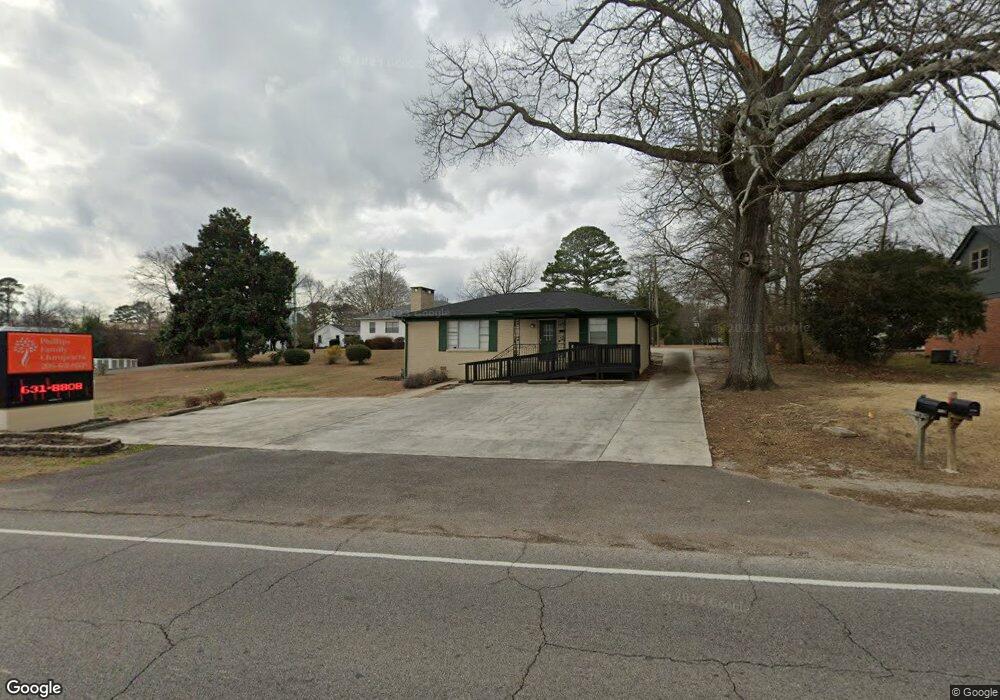
1240 Main St Gardendale, AL 35071
Estimated Value: $252,000 - $254,624
3
Beds
1
Bath
1,107
Sq Ft
$229/Sq Ft
Est. Value
About This Home
This home is located at 1240 Main St, Gardendale, AL 35071 and is currently estimated at $253,312, approximately $228 per square foot. 1240 Main St is a home located in Jefferson County with nearby schools including Snow Rogers Elementary School, Bragg Middle School, and Gardendale High School.
Ownership History
Date
Name
Owned For
Owner Type
Purchase Details
Closed on
Oct 6, 2021
Sold by
William J Lowery Llc
Bought by
Phillips Family Chiropractic Llc
Current Estimated Value
Purchase Details
Closed on
Sep 3, 2015
Sold by
David Lowery & Associates Llc
Bought by
William J Lowery Llc
Home Financials for this Owner
Home Financials are based on the most recent Mortgage that was taken out on this home.
Original Mortgage
$161,000
Interest Rate
3.94%
Mortgage Type
Commercial
Create a Home Valuation Report for This Property
The Home Valuation Report is an in-depth analysis detailing your home's value as well as a comparison with similar homes in the area
Home Values in the Area
Average Home Value in this Area
Purchase History
| Date | Buyer | Sale Price | Title Company |
|---|---|---|---|
| Phillips Family Chiropractic Llc | $215,000 | -- | |
| William J Lowery Llc | $169,000 | -- |
Source: Public Records
Mortgage History
| Date | Status | Borrower | Loan Amount |
|---|---|---|---|
| Previous Owner | William J Lowery Llc | $161,000 |
Source: Public Records
Tax History Compared to Growth
Tax History
| Year | Tax Paid | Tax Assessment Tax Assessment Total Assessment is a certain percentage of the fair market value that is determined by local assessors to be the total taxable value of land and additions on the property. | Land | Improvement |
|---|---|---|---|---|
| 2024 | $2,213 | $36,820 | -- | -- |
| 2022 | $1,820 | $30,280 | $13,280 | $17,000 |
| 2021 | $1,820 | $30,280 | $13,280 | $17,000 |
| 2020 | $1,820 | $30,280 | $13,280 | $17,000 |
| 2019 | $1,820 | $30,280 | $0 | $0 |
| 2018 | $1,489 | $24,780 | $0 | $0 |
| 2017 | $1,572 | $26,160 | $0 | $0 |
| 2016 | $1,572 | $26,160 | $0 | $0 |
| 2015 | $1,140 | $18,960 | $0 | $0 |
| 2014 | $952 | $18,800 | $0 | $0 |
| 2013 | $952 | $18,800 | $0 | $0 |
Source: Public Records
Map
Nearby Homes
- 420 Redmayne Rd
- 164 Summit Blvd
- 216 Howard Dr
- 304 Fieldstown Rd
- 1031 Mount Olive Ave Unit 17/18
- 220 Payne Rd
- 520 Parks Rd
- 411 Albert Dr
- 408 Albert Dr
- 304 Mozelle Cir
- 309 Catherine Ct
- 1515 Clover Ave
- 200 Watson Way
- 346 Gowins Dr
- 1704 Magnolia St
- 716 Kerr Dr
- 1767 Mount Olive Rd
- 868 Ridgecrest Dr
- 4362 Shivas Way Unit 238
- 4355 Shivas Way Unit 243
- 1244 Main St
- 213 Mccarty St
- 211 Redmayne Rd
- 1236 Mansfield Ave
- 1304 Main St
- 215 Mccarty St
- 210 Redmayne Rd
- 1232 Mansfield Ave
- 215 Redmayne Rd
- 1238 Mansfield Ave
- 1226 Mansfield Ave
- 216 Redmayne Rd
- 200 English Village Cir
- 1220 Mansfield Ave
- 204 English Village Cir
- 1194 Forest Dr
- 208 English Village Cir
- 320 Day St
- 313 Redmayne Rd