Estimated Value: $481,000 - $522,000
4
Beds
2
Baths
1,713
Sq Ft
$294/Sq Ft
Est. Value
About This Home
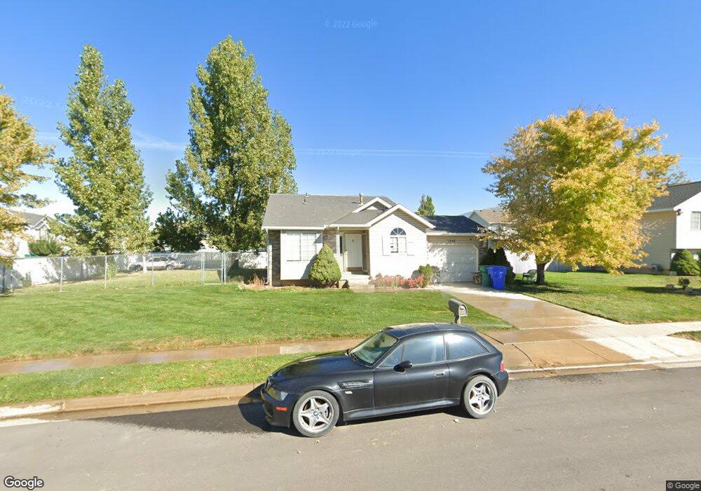
This home is located at 1240 W 1870 N, Lehi, UT 84043 and is currently estimated at $502,898, approximately $293 per square foot. 1240 W 1870 N is a home located in Utah County with nearby schools including Lehi Elementary School, Lehi Junior High School, and Lehi High School.
Ownership History
Date
Name
Owned For
Owner Type
Purchase Details
Closed on
Jun 12, 2008
Sold by
Chandler & Edward Properties Llc
Bought by
Harsh Fred B
Current Estimated Value
Home Financials for this Owner
Home Financials are based on the most recent Mortgage that was taken out on this home.
Original Mortgage
$133,600
Outstanding Balance
$85,731
Interest Rate
6.05%
Mortgage Type
Purchase Money Mortgage
Estimated Equity
$417,167
Purchase Details
Closed on
Feb 3, 2006
Sold by
Rooklidge Richard C
Bought by
Chandler & Edward Properties Llc
Purchase Details
Closed on
Dec 17, 2004
Sold by
Monson Jeffrey C and Monson Katherine E
Bought by
Rooklidge Richard C
Home Financials for this Owner
Home Financials are based on the most recent Mortgage that was taken out on this home.
Original Mortgage
$130,500
Interest Rate
5.37%
Mortgage Type
Purchase Money Mortgage
Purchase Details
Closed on
Mar 6, 2002
Sold by
Brown Andrew Blake and Brown Gina G
Bought by
Monson Jeffrey C and Monson Katherine E
Home Financials for this Owner
Home Financials are based on the most recent Mortgage that was taken out on this home.
Original Mortgage
$138,821
Interest Rate
6.78%
Mortgage Type
FHA
Create a Home Valuation Report for This Property
The Home Valuation Report is an in-depth analysis detailing your home's value as well as a comparison with similar homes in the area
Home Values in the Area
Average Home Value in this Area
Purchase History
| Date | Buyer | Sale Price | Title Company |
|---|---|---|---|
| Harsh Fred B | -- | Title One | |
| Chandler & Edward Properties Llc | -- | Accommodation | |
| Rooklidge Richard C | -- | Title One | |
| Monson Jeffrey C | -- | Old Republic Title |
Source: Public Records
Mortgage History
| Date | Status | Borrower | Loan Amount |
|---|---|---|---|
| Open | Harsh Fred B | $133,600 | |
| Previous Owner | Rooklidge Richard C | $130,500 | |
| Previous Owner | Monson Jeffrey C | $138,821 |
Source: Public Records
Tax History Compared to Growth
Tax History
| Year | Tax Paid | Tax Assessment Tax Assessment Total Assessment is a certain percentage of the fair market value that is determined by local assessors to be the total taxable value of land and additions on the property. | Land | Improvement |
|---|---|---|---|---|
| 2025 | $1,983 | $235,455 | $178,700 | $249,400 |
| 2024 | $1,983 | $232,045 | $0 | $0 |
| 2023 | $1,876 | $238,315 | $0 | $0 |
| 2022 | $1,805 | $222,365 | $0 | $0 |
| 2021 | $1,601 | $298,100 | $103,400 | $194,700 |
| 2020 | $1,363 | $277,700 | $95,700 | $182,000 |
| 2019 | $1,363 | $260,900 | $95,700 | $165,200 |
| 2018 | $1,297 | $234,700 | $90,700 | $144,000 |
| 2017 | $1,176 | $118,195 | $0 | $0 |
| 2016 | $426 | $104,500 | $0 | $0 |
| 2015 | $1,188 | $100,650 | $0 | $0 |
| 2014 | $1,161 | $97,790 | $0 | $0 |
Source: Public Records
Map
Nearby Homes
- 1272 W 1800 N
- 1249 W 1800 N
- 1011 W Mountain Way Unit 316
- 1610 N 1125 W
- 1332 W 1500 N
- 1817 W Bad Rock Cir
- 1094 W 1425 N
- 902 W 1500 N
- 5312 N Springview Ct Unit 106
- 1027 N 3685 W Unit 248
- 2191 W Swift Fox Dr Unit 274
- 999 Empire St
- 2184 W Cape Fox Way N Unit 220
- 1060 N Canvasback Dr Unit 405
- 1089 N 3685 W Unit 253
- 500 S Center St E
- 1077 N 3685 W Unit 252
- 1672 S 70 W
- 2209 W Swift Fox Way Unit 271
- 4238 N Braiken Ridge Rd W Unit 104