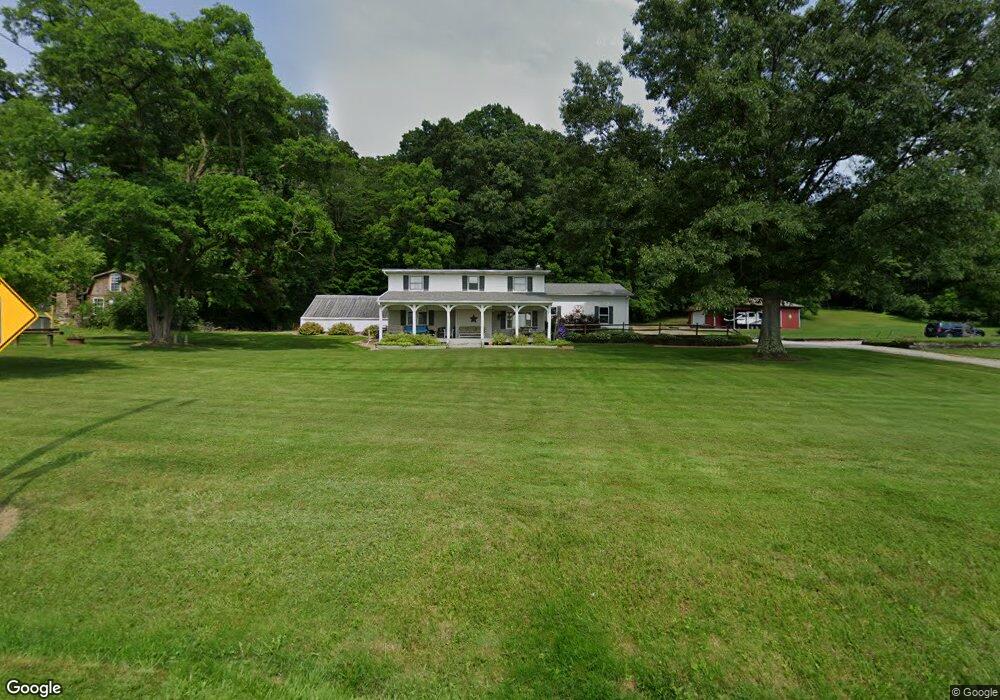
12409 Coal Bank Rd Doylestown, OH 44230
Estimated Value: $346,314 - $419,000
4
Beds
1
Bath
2,056
Sq Ft
$183/Sq Ft
Est. Value
About This Home
This home is located at 12409 Coal Bank Rd, Doylestown, OH 44230 and is currently estimated at $376,829, approximately $183 per square foot. 12409 Coal Bank Rd is a home located in Wayne County with nearby schools including Hazel Harvey Elementary School, Chippewa Intermediate School, and Chippewa Jr./Sr. High School.
Ownership History
Date
Name
Owned For
Owner Type
Purchase Details
Closed on
Oct 13, 2008
Sold by
White Byrne and Powell David S
Bought by
Bishop Rebecca J
Current Estimated Value
Purchase Details
Closed on
Jul 17, 1991
Sold by
Whitehead William E
Bought by
Whitehead Gerald A and Whitehead Pame
Purchase Details
Closed on
Aug 1, 1986
Bought by
Whitehead William E
Create a Home Valuation Report for This Property
The Home Valuation Report is an in-depth analysis detailing your home's value as well as a comparison with similar homes in the area
Home Values in the Area
Average Home Value in this Area
Purchase History
| Date | Buyer | Sale Price | Title Company |
|---|---|---|---|
| Bishop Rebecca J | -- | Attorney | |
| Whitehead Gerald A | $53,000 | -- | |
| Whitehead William E | $45,000 | -- |
Source: Public Records
Tax History Compared to Growth
Tax History
| Year | Tax Paid | Tax Assessment Tax Assessment Total Assessment is a certain percentage of the fair market value that is determined by local assessors to be the total taxable value of land and additions on the property. | Land | Improvement |
|---|---|---|---|---|
| 2024 | $3,114 | $85,510 | $17,250 | $68,260 |
| 2023 | $2,966 | $85,510 | $17,250 | $68,260 |
| 2022 | $2,212 | $58,570 | $11,810 | $46,760 |
| 2021 | $2,224 | $58,570 | $11,810 | $46,760 |
| 2020 | $2,240 | $58,570 | $11,810 | $46,760 |
| 2019 | $1,694 | $42,580 | $10,780 | $31,800 |
| 2018 | $1,711 | $42,580 | $10,780 | $31,800 |
| 2017 | $1,697 | $42,580 | $10,780 | $31,800 |
| 2016 | $1,654 | $40,940 | $10,360 | $30,580 |
| 2015 | $1,647 | $40,940 | $10,360 | $30,580 |
| 2014 | $1,446 | $40,940 | $10,360 | $30,580 |
| 2013 | $1,452 | $39,870 | $9,740 | $30,130 |
Source: Public Records
Map
Nearby Homes
- 46 Hidden Pond Dr
- 270 Maple St
- 11626 Black Diamond Rd
- 100 Merlot Ct
- 0 S Portage St
- 325 Catawba Path
- 154 Circle Dr
- 605 Vineyard Way
- 12214 Vince Dr
- 16441 Bieri Rd
- 580 Thorn Way
- 680 Thorn Way
- 620 Thorn Way
- 10670 Coal Bank Rd
- 0 Akron Rd Unit 5123781
- 436 N Portage St
- 517 N Portage St
- 340 Gates St
- 500 W Clinton St
- 14328 Calaboone Rd
- 12369 Coal Bank Rd
- 12461 Coal Bank Rd
- 12463 Coal Bank Rd
- 12227 Coal Bank Rd
- 16330 Old Chippewa Trail
- 16290 Old Chippewa Trail
- 16260 Old Chippewa Trail
- 480 Meadow Ridge Trail
- 12645 Coal Bank Rd
- 16335 Old Chippewa Trail
- 500 Wild Cherry Ln
- 460 Meadow Ridge Trail
- 16291 Old Chippewa Trail
- 520 Wild Cherry Ln
- 540 Wild Cherry Ln
- 12648 Coal Bank Rd
- 16404 Old Chippewa Trail
- 15975 Mccallum Dr
- 16000 Mccallum Dr