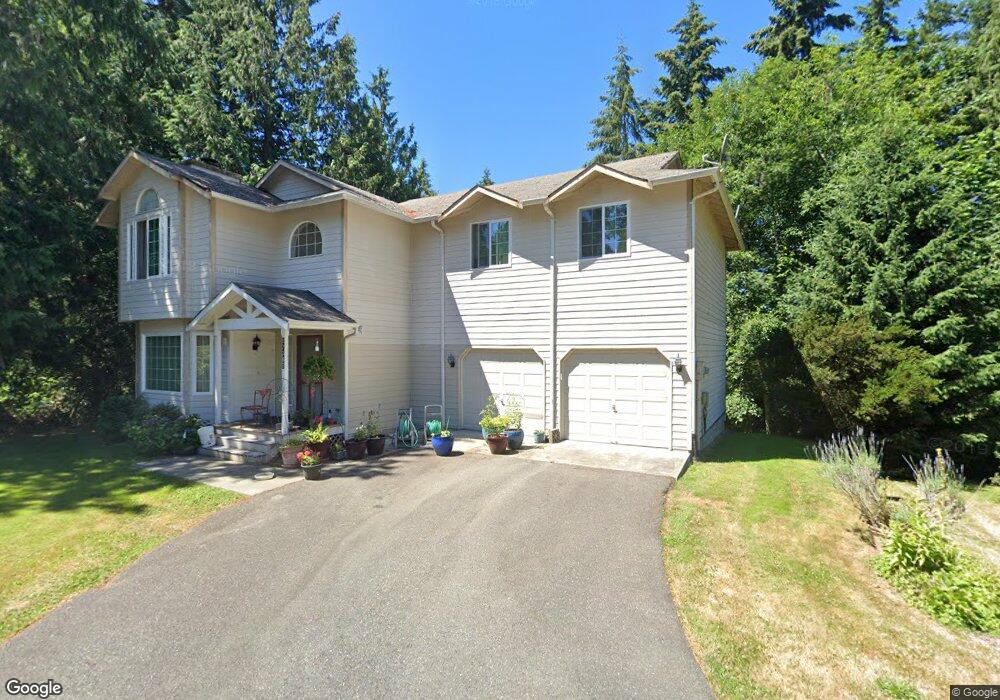
12409 S Keyport Rd NE Poulsbo, WA 98370
Estimated Value: $909,119 - $995,000
4
Beds
5
Baths
2,800
Sq Ft
$339/Sq Ft
Est. Value
About This Home
This home is located at 12409 S Keyport Rd NE, Poulsbo, WA 98370 and is currently estimated at $949,280, approximately $339 per square foot. 12409 S Keyport Rd NE is a home located in Kitsap County with nearby schools including Hilder Pearson Elementary School, Poulsbo Middle School, and North Kitsap High School.
Ownership History
Date
Name
Owned For
Owner Type
Purchase Details
Closed on
Aug 26, 2008
Sold by
Ferguson & Cole Inc
Bought by
Hare Timothy L and Hare Sheryl
Current Estimated Value
Home Financials for this Owner
Home Financials are based on the most recent Mortgage that was taken out on this home.
Original Mortgage
$465,000
Interest Rate
6.59%
Mortgage Type
VA
Purchase Details
Closed on
Dec 1, 2005
Sold by
Olsen Jean S
Bought by
Ferguson & Cole Inc
Home Financials for this Owner
Home Financials are based on the most recent Mortgage that was taken out on this home.
Original Mortgage
$396,000
Interest Rate
6.14%
Mortgage Type
Construction
Create a Home Valuation Report for This Property
The Home Valuation Report is an in-depth analysis detailing your home's value as well as a comparison with similar homes in the area
Home Values in the Area
Average Home Value in this Area
Purchase History
| Date | Buyer | Sale Price | Title Company |
|---|---|---|---|
| Hare Timothy L | $465,280 | Pacific Nw Title | |
| Ferguson & Cole Inc | $125,280 | Pacific Nw Title |
Source: Public Records
Mortgage History
| Date | Status | Borrower | Loan Amount |
|---|---|---|---|
| Open | Hare Timothy L | $465,000 | |
| Previous Owner | Ferguson & Cole Inc | $396,000 |
Source: Public Records
Tax History Compared to Growth
Tax History
| Year | Tax Paid | Tax Assessment Tax Assessment Total Assessment is a certain percentage of the fair market value that is determined by local assessors to be the total taxable value of land and additions on the property. | Land | Improvement |
|---|---|---|---|---|
| 2026 | $7,358 | $802,910 | $146,090 | $656,820 |
| 2025 | $7,358 | $802,910 | $146,090 | $656,820 |
| 2024 | $6,807 | $770,180 | $144,190 | $625,990 |
| 2023 | $6,756 | $770,180 | $144,190 | $625,990 |
| 2022 | $6,033 | $616,980 | $120,160 | $496,820 |
| 2021 | $5,716 | $551,480 | $107,660 | $443,820 |
| 2020 | $5,386 | $526,810 | $102,860 | $423,950 |
| 2019 | $5,219 | $493,580 | $96,130 | $397,450 |
| 2018 | $5,218 | $415,300 | $86,780 | $328,520 |
| 2017 | $4,916 | $415,300 | $86,780 | $328,520 |
| 2016 | $4,932 | $381,680 | $86,780 | $294,900 |
| 2015 | $4,716 | $381,680 | $86,780 | $294,900 |
| 2014 | -- | $366,150 | $86,780 | $279,370 |
| 2013 | -- | $366,150 | $86,780 | $279,370 |
Source: Public Records
Map
Nearby Homes
- 0 xxxx Brownsville Hwy NE
- 1810 NE Duck Pond Way
- 2331 NE Toscana Way
- 2331 Lot C+D NE Toscana Way
- 0 S Keyport Rd NE
- 0 Brownsville Hwy NE Unit NWM2408193
- 0 NE Solar View Ct
- 10825 Brownsville Hwy NE
- 13977 Blackberry Ln NE
- 2393 NE Trail Way
- 1354 Hoffs Dr
- 10211 Ogle Rd NE
- 135 Walker Rd NW
- 2051 NE Marina Vista Ct
- 9809 Shepler Rd NE
- 129 Xx Stiller Blvd NW
- 1533 NE Tagholm Rd
- 1422 NW Swenson Ct
- 13600 Hillcrest St NW
- 13083 Lake Shore Dr NW
- 12373 S Keyport Rd NE
- 12425 S Keyport Rd NE
- 12275 S Keyport Rd NE
- 12177 S Keyport Rd NE
- 12169 S Keyport Rd NE
- 12361 S Keyport Rd NE
- 12379 S Keyport Rd NE
- 12205 S Keyport Rd NE
- 12108 Brownsville Hwy NE
- 12429 S Keyport Rd NE
- 12161 S Keyport Rd NE
- 12391 S Keyport Rd NE
- 13735 Brownsville Hwy NE
- 13727 Brownsville Hwy NE
- 0 XXX Brownsville Hwy NE
- 12125 S Keyport Rd NE
- 12455 S Keyport Rd NE
- 12268 S Keyport Rd NE
- 12300 S Keyport Rd NE
- 12390 S Keyport Rd NE