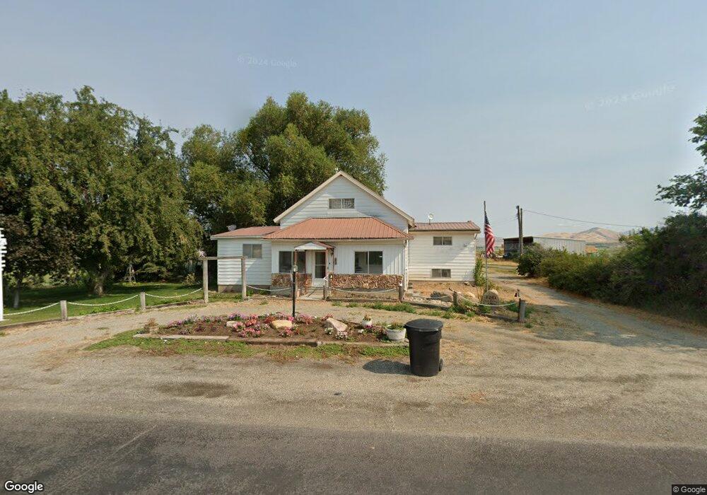
1241 E Mountain Home Rd Lewiston, UT 84320
Estimated Value: $421,000 - $629,000
Studio
--
Bath
1,924
Sq Ft
$262/Sq Ft
Est. Value
About This Home
This home is located at 1241 E Mountain Home Rd, Lewiston, UT 84320 and is currently estimated at $503,365, approximately $261 per square foot. 1241 E Mountain Home Rd is a home with nearby schools including Lewiston School, White Pine Middle School, and North Cache Middle School.
Ownership History
Date
Name
Owned For
Owner Type
Purchase Details
Closed on
Jul 11, 2023
Sold by
Allen Dan
Bought by
Allen Farm & Livestock Llc
Current Estimated Value
Purchase Details
Closed on
Apr 27, 2023
Sold by
Gary G Allen Family Revocable Trust
Bought by
Allen Dan
Home Financials for this Owner
Home Financials are based on the most recent Mortgage that was taken out on this home.
Original Mortgage
$250,000
Interest Rate
6.42%
Mortgage Type
Credit Line Revolving
Create a Home Valuation Report for This Property
The Home Valuation Report is an in-depth analysis detailing your home's value as well as a comparison with similar homes in the area
Purchase History
| Date | Buyer | Sale Price | Title Company |
|---|---|---|---|
| Allen Farm & Livestock Llc | -- | None Listed On Document | |
| Allen Dan | -- | None Listed On Document |
Source: Public Records
Mortgage History
| Date | Status | Borrower | Loan Amount |
|---|---|---|---|
| Previous Owner | Allen Dan | $250,000 |
Source: Public Records
Tax History
| Year | Tax Paid | Tax Assessment Tax Assessment Total Assessment is a certain percentage of the fair market value that is determined by local assessors to be the total taxable value of land and additions on the property. | Land | Improvement |
|---|---|---|---|---|
| 2025 | $1,498 | $239,810 | $0 | $0 |
| 2024 | $1,603 | $236,960 | $0 | $0 |
| 2023 | $1,707 | $236,200 | $0 | $0 |
| 2022 | $1,416 | $187,490 | $0 | $0 |
| 2021 | $1,361 | $278,430 | $105,000 | $173,430 |
| 2020 | $1,074 | $198,258 | $61,250 | $137,008 |
| 2019 | $1,136 | $198,258 | $61,250 | $137,008 |
| 2018 | $1,096 | $185,250 | $61,250 | $124,000 |
| 2017 | $947 | $87,965 | $0 | $0 |
| 2016 | $959 | $87,955 | $0 | $0 |
| 2015 | $944 | $87,950 | $0 | $0 |
| 2014 | $916 | $87,995 | $0 | $0 |
| 2013 | -- | $88,060 | $0 | $0 |
Source: Public Records
Map
Nearby Homes
- 1009 E High Creek Rd
- 13485 N 2200 E
- 12506 N 525 E Unit 6
- 12489 N 525 E
- 12455 N 525 E Unit 1
- 12455 N 525 E
- 12506 N 525 E
- 12484 N 525 E Unit 7
- 12521 N 525 E
- 12518 N 525 E Unit 5
- 12489 N 525 E Unit 2
- 2400 W
- 12484 N 525 E
- 12518 N 525 E
- 12456 N 525 E Unit 8
- 12521 N 525 E Unit 3
- 12456 N 525 E
- 684 N Cherry Creek Pkwy E
- 684 N Cherry Creek Pkwy E Unit 26
- 673 Cherry Creek Pkwy Unit 24
- 1209 E Mountain Home Rd
- 1271 E Mountain Home Rd
- 1197 E 13000 N
- 12985 N 1200 E
- 1305 E 13000 N
- 1151 E 13000 N
- 1160 E 13000 N
- 2170 E Mountain Home Rd Unit 2
- 1113 E 13000 N
- 1393 E 13000 N
- 1411 E Mountain Home Rd
- 1095 E 13000 N
- 1301 E 12800 N
- 1467 E Mountain Home Rd
- 12800 N 1200 E
- 1256 E 12800 N
- 12795 N 1200 E
- 1487 E 13000 N
- 12780 N 1300 E
- 1017 E 13000 N
Your Personal Tour Guide
Ask me questions while you tour the home.