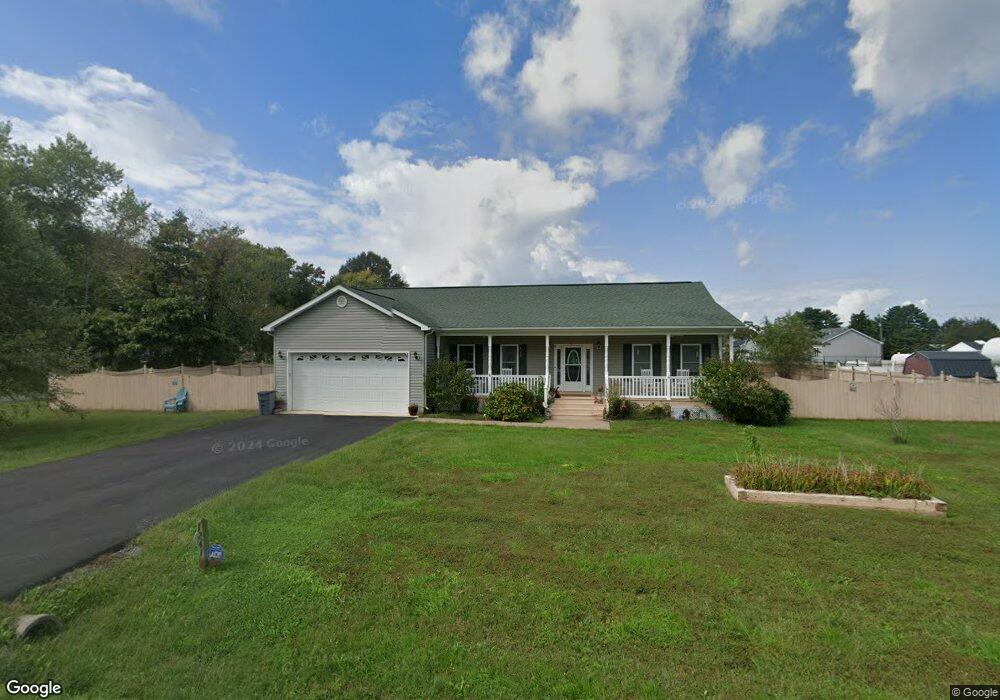
1241 Ebb Tide Dr Colonial Beach, VA 22443
Estimated Value: $345,000 - $415,000
3
Beds
2
Baths
2,516
Sq Ft
$149/Sq Ft
Est. Value
About This Home
This home is located at 1241 Ebb Tide Dr, Colonial Beach, VA 22443 and is currently estimated at $375,815, approximately $149 per square foot. 1241 Ebb Tide Dr is a home located in Westmoreland County with nearby schools including Montross Middle School and Westmoreland High School.
Ownership History
Date
Name
Owned For
Owner Type
Purchase Details
Closed on
Apr 8, 2015
Sold by
Baker William E and Baker Jeanette Laura
Bought by
Baker Iii Trustee William Edward and William E Baker Iii Rev Living
Current Estimated Value
Purchase Details
Closed on
Aug 28, 2014
Sold by
Gray Construction Inc
Bought by
Baker William E
Home Financials for this Owner
Home Financials are based on the most recent Mortgage that was taken out on this home.
Original Mortgage
$206,100
Interest Rate
4.14%
Mortgage Type
New Conventional
Create a Home Valuation Report for This Property
The Home Valuation Report is an in-depth analysis detailing your home's value as well as a comparison with similar homes in the area
Home Values in the Area
Average Home Value in this Area
Purchase History
| Date | Buyer | Sale Price | Title Company |
|---|---|---|---|
| Baker Iii Trustee William Edward | -- | -- | |
| Baker William E | $217,236 | -- |
Source: Public Records
Mortgage History
| Date | Status | Borrower | Loan Amount |
|---|---|---|---|
| Previous Owner | Baker William E | $206,100 |
Source: Public Records
Tax History
| Year | Tax Paid | Tax Assessment Tax Assessment Total Assessment is a certain percentage of the fair market value that is determined by local assessors to be the total taxable value of land and additions on the property. | Land | Improvement |
|---|---|---|---|---|
| 2025 | $1,950 | $286,700 | $31,000 | $255,700 |
| 2024 | $1,950 | $286,700 | $31,000 | $255,700 |
| 2023 | $1,778 | $286,700 | $31,000 | $255,700 |
| 2022 | $1,778 | $286,700 | $31,000 | $255,700 |
| 2021 | $1,667 | $219,400 | $31,000 | $188,400 |
| 2020 | $1,667 | $219,400 | $31,000 | $188,400 |
| 2019 | $1,426 | $219,400 | $31,000 | $188,400 |
| 2018 | $1,338 | $219,400 | $31,000 | $188,400 |
| 2017 | -- | $219,400 | $31,000 | $188,400 |
| 2016 | $1,316 | $219,400 | $31,000 | $188,400 |
| 2015 | -- | $221,300 | $31,000 | $190,300 |
| 2014 | -- | $0 | $0 | $0 |
| 2013 | -- | $12,500 | $12,500 | $0 |
Source: Public Records
Map
Nearby Homes
- 187 Brooks Dr
- 100 Latane Dr
- 0 Pine St Unit VAWE2007608
- 0 Randall Rd Unknown
- 19 Evergreen Dr Unit 19
- 19 Evergreen Dr
- 16 Evergreen Dr
- 18 Evergreen Dr Unit 18
- 17 Evergreen Dr
- 16 Evergreen Dr Unit 16
- 17 Evergreen Dr Unit 17
- 18 Evergreen Dr
- 57 Oak Ln
- Lot 3 Paynes Point Dr
- 175 Rose Way
- 218 Circle Ln
- 62 Rose Way
- 38 Circle Ln
- Lot 9 Section 10 Sebastian Ave
- 3 Shore Dr
- 175 Guthrie Rd
- 8 Guthrie Rd
- 5 Guthrie Rd
- 0 Guthrie Rd Unit 1006664358
- 0 Guthrie Rd Unit WE7270740
- 0 Guthrie Rd Unit 1003678140
- 31 Pearson Dr
- 163 Guthrie Rd
- 1242 Ebb Tide Dr
- 1256 Ebb Tide Dr
- 103 Pearson Dr
- 1274 Ebb Tide Dr
- Lot 6 Guthrie Rd
- 1202 Ebb Tide Dr
- 81 Pearson Dr
- 350 Richmond Rd
- 40 Pearson Dr
- 1302 Ebb Tide Dr
- 260 Guthrie Rd
- TBB Ebb Tide Dr
Your Personal Tour Guide
Ask me questions while you tour the home.