
Seller's Agent in 2025
Elizabeth Tritschler
William Raveis Real Estate
(203) 913-9454
122 Total Sales
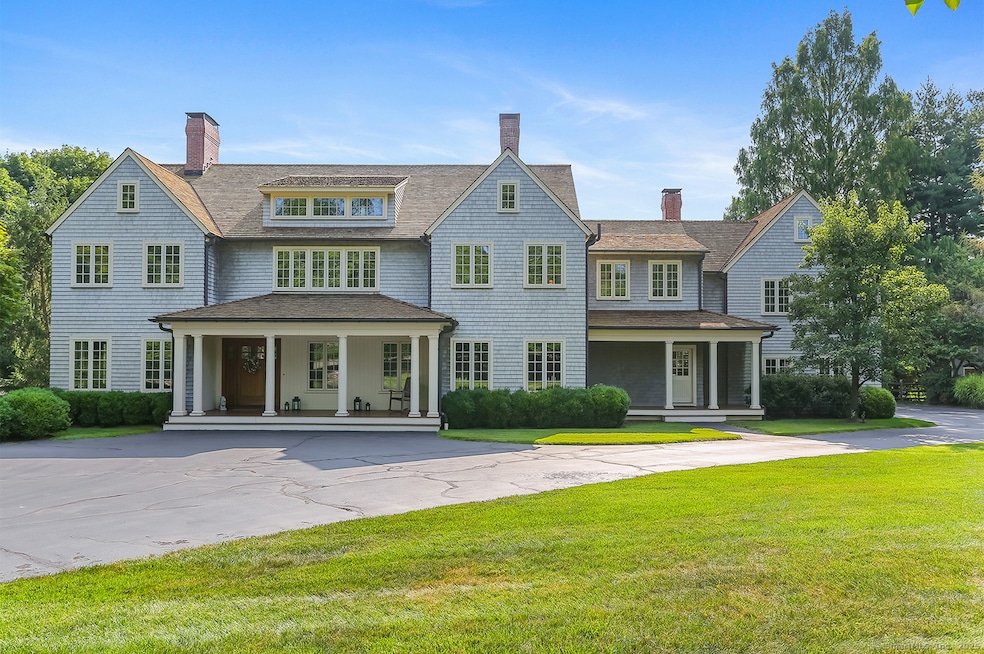
Southport Custom Shingle-Style Colonial Designed by renowned architect Jack Franzen, this exquisite six-bedroom, Energy Star-rated home offers timeless design and exceptional efficiency, including geothermal heating and cooling. Privately sited on 2.48 acres of beautifully manicured, level property in a coveted Southport neighborhood, the residence blends classic architecture with modern luxury. Inside, finely crafted details abound-hardwood floors, imported marbles, and custom cabinetry set the tone. Elegant living and entertaining spaces include a formal living room with fireplace, a cozy den/office with fireplace, and a generous family room with yet another fireplace. Numerous French doors open to a sweeping covered porch, inviting effortless indoor-outdoor living. Step outside to enjoy resort-style amenities: a saltwater pool, fire pit, professional-grade, lit tennis court, and expansive patios perfect for gathering and relaxing. This exceptional property offers both convenience and privacy-a rare and refined retreat in the heart of Southport.
Last Agent to Sell the Property
William Raveis Real Estate License #RES.0774354 Listed on: 07/12/2025
Last Buyer's Agent
William Raveis Real Estate License #RES.0774354 Listed on: 07/12/2025
| Date | Type | Sale Price | Title Company |
|---|---|---|---|
| Warranty Deed | $3,800,000 | -- | |
| Warranty Deed | $2,950,000 | -- | |
| Warranty Deed | $2,950,000 | -- | |
| Warranty Deed | $2,590,000 | -- | |
| Warranty Deed | $2,590,000 | -- | |
| Warranty Deed | $2,475,000 | -- | |
| Warranty Deed | $2,475,000 | -- |
| Date | Status | Loan Amount | Loan Type |
|---|---|---|---|
| Open | $2,300,000 | Future Advance Clause Open End Mortgage | |
| Previous Owner | $575,000 | No Value Available | |
| Previous Owner | $250,000 | No Value Available |
| Date | Event | Price | List to Sale | Price per Sq Ft |
|---|---|---|---|---|
| 10/06/2025 10/06/25 | Sold | $3,800,000 | +1.3% | $458 / Sq Ft |
| 09/06/2025 09/06/25 | Pending | -- | -- | -- |
| 07/12/2025 07/12/25 | For Sale | $3,750,000 | -- | $452 / Sq Ft |
| Year | Tax Paid | Tax Assessment Tax Assessment Total Assessment is a certain percentage of the fair market value that is determined by local assessors to be the total taxable value of land and additions on the property. | Land | Improvement |
|---|---|---|---|---|
| 2025 | $39,869 | $1,404,340 | $626,500 | $777,840 |
| 2024 | $39,181 | $1,404,340 | $626,500 | $777,840 |
| 2023 | $38,633 | $1,404,340 | $626,500 | $777,840 |
| 2022 | $38,254 | $1,404,340 | $626,500 | $777,840 |
| 2021 | $35,702 | $1,323,280 | $626,500 | $696,780 |
| 2020 | $37,448 | $1,397,830 | $623,070 | $774,760 |
| 2019 | $37,448 | $1,397,830 | $623,070 | $774,760 |
| 2018 | $36,847 | $1,397,830 | $623,070 | $774,760 |
| 2017 | $36,092 | $1,397,830 | $623,070 | $774,760 |
| 2016 | $35,575 | $1,397,830 | $623,070 | $774,760 |
| 2015 | $29,675 | $1,197,070 | $407,330 | $789,740 |
| 2014 | $29,209 | $1,197,070 | $407,330 | $789,740 |
Seller's Agent in 2025
Elizabeth Tritschler
William Raveis Real Estate
(203) 913-9454
122 Total Sales
Seller Co-Listing Agent in 2025
Al Filippone
William Raveis Real Estate
(203) 655-5358
25 Total Sales
Source: SmartMLS
MLS Number: 24115614
APN: FAIR-000246-000000-000045
Disclaimer: Certain information contained herein is derived from information provided by parties other than Homes.com. All information provided is deemed reliable, but is not guaranteed to be accurate and should be independently verified.
![]() IDX information is provided exclusively for personal, non-commercial use, and may not be used for any purpose other than to identify prospective properties consumers may be interested in purchasing. Information is deemed reliable but not guaranteed.
IDX information is provided exclusively for personal, non-commercial use, and may not be used for any purpose other than to identify prospective properties consumers may be interested in purchasing. Information is deemed reliable but not guaranteed.