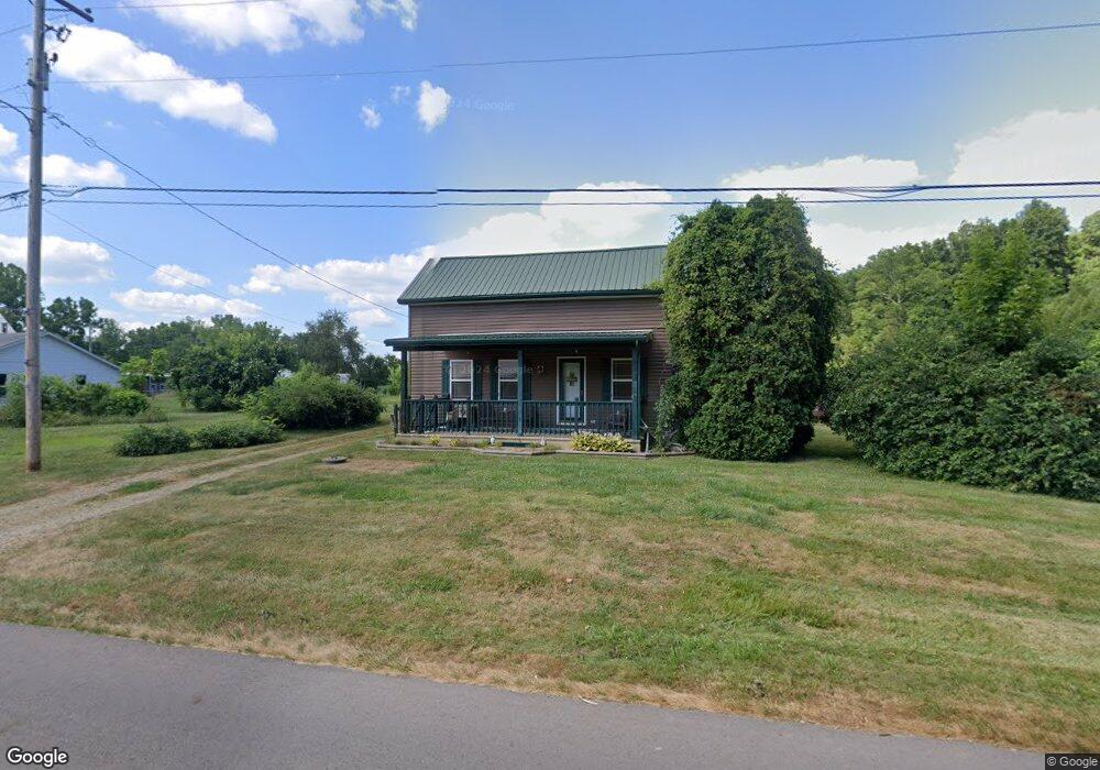
1241 Main St Richmond Dale, OH 45673
Estimated Value: $90,276 - $135,000
3
Beds
1
Bath
1,428
Sq Ft
$81/Sq Ft
Est. Value
About This Home
This home is located at 1241 Main St, Richmond Dale, OH 45673 and is currently estimated at $115,569, approximately $80 per square foot. 1241 Main St is a home located in Ross County with nearby schools including Southeastern Elementary School, Southeastern Middle School, and Southeastern High School.
Ownership History
Date
Name
Owned For
Owner Type
Purchase Details
Closed on
Nov 23, 2015
Sold by
Turner Keith E
Bought by
Mcwhorter Jason A and Mcwhorter Rachele L
Current Estimated Value
Home Financials for this Owner
Home Financials are based on the most recent Mortgage that was taken out on this home.
Original Mortgage
$62,700
Interest Rate
3.88%
Mortgage Type
Seller Take Back
Purchase Details
Closed on
Dec 27, 2013
Sold by
Wells Fargo Bank Na
Bought by
Turner Keith E
Purchase Details
Closed on
Oct 29, 2013
Sold by
Mcgowan Richard
Bought by
Wells Fargo Bank Na
Create a Home Valuation Report for This Property
The Home Valuation Report is an in-depth analysis detailing your home's value as well as a comparison with similar homes in the area
Home Values in the Area
Average Home Value in this Area
Purchase History
| Date | Buyer | Sale Price | Title Company |
|---|---|---|---|
| Mcwhorter Jason A | $65,000 | None Available | |
| Turner Keith E | $21,000 | Insight Title Co | |
| Wells Fargo Bank Na | $38,000 | None Available |
Source: Public Records
Mortgage History
| Date | Status | Borrower | Loan Amount |
|---|---|---|---|
| Closed | Mcwhorter Jason A | $62,700 |
Source: Public Records
Tax History Compared to Growth
Tax History
| Year | Tax Paid | Tax Assessment Tax Assessment Total Assessment is a certain percentage of the fair market value that is determined by local assessors to be the total taxable value of land and additions on the property. | Land | Improvement |
|---|---|---|---|---|
| 2024 | $669 | $17,960 | $4,810 | $13,150 |
| 2023 | $637 | $17,960 | $4,810 | $13,150 |
| 2022 | $651 | $17,960 | $4,810 | $13,150 |
| 2021 | $663 | $16,070 | $3,850 | $12,220 |
| 2020 | $668 | $16,070 | $3,850 | $12,220 |
| 2019 | $668 | $16,070 | $3,850 | $12,220 |
| 2018 | $554 | $13,110 | $3,480 | $9,630 |
| 2017 | $555 | $13,110 | $3,480 | $9,630 |
| 2016 | $542 | $13,110 | $3,480 | $9,630 |
| 2015 | $546 | $13,110 | $3,480 | $9,630 |
| 2014 | $534 | $13,110 | $3,480 | $9,630 |
| 2013 | $536 | $13,110 | $3,480 | $9,630 |
Source: Public Records
Map
Nearby Homes
- 1048 Jackson
- 379 Mutton Run Rd
- 485 Springer Rd
- 1587 St Rt 35
- 0 Hay Hollow Rd
- 55 Cain Rd
- 36665 U S 50
- 1011 Lee Hollow Rd
- 0 Highway 50
- 0 U S 35
- 1255 Higby Rd Unit 197732
- 5654 Stoney Creek Rd
- 16932 State Route 335
- 0 Three Locks Rd
- 3050 Wilson Run Rd
- 84 Newman Hollow Rd
- 3988 W St Rt 35
- 1781 Big Rock Rd
- 0 Erwin Hollow Rd
- 0 Meacham Rd