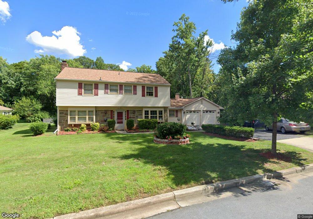
12411 Cedarbrook Ln Laurel, MD 20708
South Laurel NeighborhoodEstimated Value: $559,725 - $624,000
Studio
3
Baths
2,740
Sq Ft
$218/Sq Ft
Est. Value
About This Home
This home is located at 12411 Cedarbrook Ln, Laurel, MD 20708 and is currently estimated at $597,431, approximately $218 per square foot. 12411 Cedarbrook Ln is a home located in Prince George's County with nearby schools including Montpelier Elementary School, Dwight D. Eisenhower Middle School, and Laurel High School.
Ownership History
Date
Name
Owned For
Owner Type
Purchase Details
Closed on
Jul 27, 2001
Sold by
Curry James A
Bought by
Ohaka Louis C and Ohaka Nkemdilim
Current Estimated Value
Purchase Details
Closed on
Apr 9, 1996
Sold by
Dejarnette Kenneth
Bought by
Curry James A and Curry Sue A
Purchase Details
Closed on
Nov 9, 1972
Sold by
Keepers William C
Bought by
Dejarnette Kenneth and Dejarnette Beryl K
Create a Home Valuation Report for This Property
The Home Valuation Report is an in-depth analysis detailing your home's value as well as a comparison with similar homes in the area
Home Values in the Area
Average Home Value in this Area
Purchase History
| Date | Buyer | Sale Price | Title Company |
|---|---|---|---|
| Ohaka Louis C | $223,500 | -- | |
| Curry James A | $192,500 | -- | |
| Dejarnette Kenneth | $48,000 | -- |
Source: Public Records
Tax History
| Year | Tax Paid | Tax Assessment Tax Assessment Total Assessment is a certain percentage of the fair market value that is determined by local assessors to be the total taxable value of land and additions on the property. | Land | Improvement |
|---|---|---|---|---|
| 2025 | $5,904 | $509,500 | $128,000 | $381,500 |
| 2024 | $5,904 | $478,067 | -- | -- |
| 2023 | $5,658 | $446,633 | $0 | $0 |
| 2022 | $5,358 | $415,200 | $103,000 | $312,200 |
| 2021 | $5,160 | $403,333 | $0 | $0 |
| 2020 | $5,075 | $391,467 | $0 | $0 |
| 2019 | $4,963 | $379,600 | $101,500 | $278,100 |
| 2018 | $4,790 | $360,333 | $0 | $0 |
| 2017 | $4,644 | $341,067 | $0 | $0 |
| 2016 | -- | $321,800 | $0 | $0 |
| 2015 | $4,002 | $315,433 | $0 | $0 |
| 2014 | $4,002 | $309,067 | $0 | $0 |
Source: Public Records
Map
Nearby Homes
- 12600 Cedarbrook Ln
- 8714 Granite Ln
- 8904 Royal Ridge Ln
- 12201 Mount Pleasant Dr
- 8908 Eastbourne Ln
- 9303 Ispahan Loop
- 12122 Running Bull Way
- 12124 Running Bull Way
- 12128 Running Bull Way
- 12017 Apache Tears Cir
- 8479 Imperial Dr
- 12109 Spirit Ave
- 12107 Spirit Ave
- 12105 Spirit Ave
- 12103 Spirit Ave
- 12101 Spirit Ave
- 12513 Laurel Bowie Rd
- 8415 Snowden Oaks Place
- 8307 Snowden Oaks Place
- 9102 Erfurt Ct
- 12501 Cedarbrook Ln
- 9000 Golden Pass
- 12406 Silverbirch Ln
- 12503 Cedarbrook Ln
- 12408 Silverbirch Ln
- 12410 Cedarbrook Ln
- 9004 Golden Pass
- 8906 Boxford Ct
- 12500 Cedarbrook Ln
- 12410 Silverbirch Ln
- 9001 Golden Pass
- 12505 Cedarbrook Ln
- 12504 Cedarbrook Ln
- 8904 Boxford Ct
- 8907 Churchfield Ln
- 12412 Silverbirch Ln
- 8907 Boxford Ct
- 9003 Golden Pass
- 8908 Churchfield Ln
- 12403 Cedarbrook Ln
Your Personal Tour Guide
Ask me questions while you tour the home.