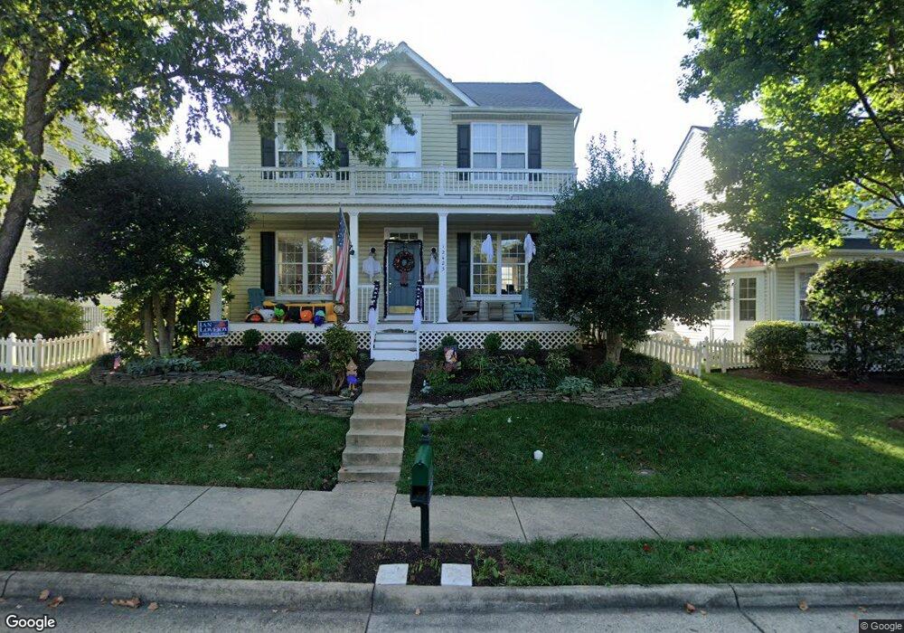
12423 Burghead Dr Bristow, VA 20136
Villages At Saybrooke NeighborhoodEstimated Value: $675,510 - $736,000
4
Beds
4
Baths
1,840
Sq Ft
$381/Sq Ft
Est. Value
About This Home
This home is located at 12423 Burghead Dr, Bristow, VA 20136 and is currently estimated at $700,628, approximately $380 per square foot. 12423 Burghead Dr is a home located in Prince William County with nearby schools including Patriot High School, Cedar Point Elementary School, and E.H. Marsteller Middle School.
Ownership History
Date
Name
Owned For
Owner Type
Purchase Details
Closed on
Mar 29, 1999
Sold by
Coscan Washington Inc
Bought by
Owens Charles K
Current Estimated Value
Home Financials for this Owner
Home Financials are based on the most recent Mortgage that was taken out on this home.
Original Mortgage
$183,850
Outstanding Balance
$45,548
Interest Rate
6.78%
Estimated Equity
$655,080
Create a Home Valuation Report for This Property
The Home Valuation Report is an in-depth analysis detailing your home's value as well as a comparison with similar homes in the area
Home Values in the Area
Average Home Value in this Area
Purchase History
| Date | Buyer | Sale Price | Title Company |
|---|---|---|---|
| Owens Charles K | $183,995 | -- |
Source: Public Records
Mortgage History
| Date | Status | Borrower | Loan Amount |
|---|---|---|---|
| Open | Owens Charles K | $183,850 |
Source: Public Records
Tax History
| Year | Tax Paid | Tax Assessment Tax Assessment Total Assessment is a certain percentage of the fair market value that is determined by local assessors to be the total taxable value of land and additions on the property. | Land | Improvement |
|---|---|---|---|---|
| 2025 | $5,867 | $655,000 | $184,200 | $470,800 |
| 2024 | $5,867 | $589,900 | $173,700 | $416,200 |
| 2023 | $5,756 | $553,200 | $149,700 | $403,500 |
| 2022 | $5,910 | $523,300 | $124,500 | $398,800 |
| 2021 | $5,554 | $454,700 | $110,600 | $344,100 |
| 2020 | $6,566 | $423,600 | $103,600 | $320,000 |
| 2019 | $6,518 | $420,500 | $103,600 | $316,900 |
| 2018 | $4,690 | $388,400 | $98,500 | $289,900 |
| 2017 | $4,708 | $381,100 | $98,500 | $282,600 |
| 2016 | $4,520 | $369,100 | $89,400 | $279,700 |
| 2015 | $4,359 | $360,000 | $89,400 | $270,600 |
| 2014 | $4,359 | $348,100 | $86,800 | $261,300 |
Source: Public Records
Map
Nearby Homes
- 12458 Hadrians Ct
- 12511 Heykens Ln
- 12360 Corncrib Ct
- 12217 Wheat Mill Loop
- 10021 Hume Ct
- 12203 Aster Rd
- 12151 Drum Salute Place
- 12172 Aster Rd
- 10351 Spring Iris Dr
- 9822 Maitland Loop
- 9856 Maitland Loop
- 12021 Spring Beauty Rd
- 10410 Kettle Run Rd
- 12017 Youngtree Ct
- 9568 Tarvie Cir
- 10582 Poagues Battery Dr
- 11701 Town Green Rd
- 9653 Innerwick Place
- 10615 Bristow Station Dr
- 11650 Iron Brigade Unit Ave
- 12419 Burghead Dr
- 12427 Burghead Dr
- 10045 Woolen Kilt Ct
- 12415 Burghead Dr
- 12482 Selkirk Cir
- 10049 Woolen Kilt Ct
- 12480 Selkirk Cir
- 12431 Burghead Dr
- 10042 Woolen Kilt Ct
- 12411 Burghead Dr
- 12478 Selkirk Cir
- 10177 Elgin Way
- 12476 Selkirk Cir
- 10175 Elgin Way
- 10034 Dragoon Guards Ct
- 12474 Selkirk Cir
- 10053 Woolen Kilt Ct
- 12435 Burghead Dr
- 10044 Woolen Kilt Ct
- 10173 Elgin Way
Your Personal Tour Guide
Ask me questions while you tour the home.