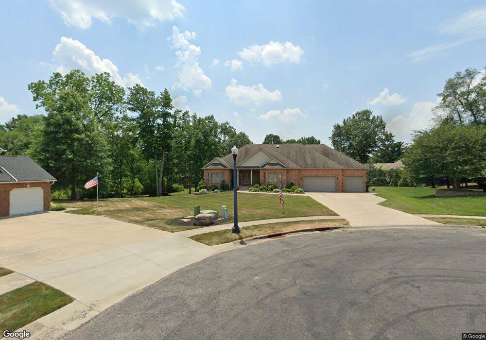
12425 Stover Farm Dr NW Canal Fulton, OH 44614
Estimated Value: $434,000 - $645,828
3
Beds
5
Baths
3,125
Sq Ft
$172/Sq Ft
Est. Value
About This Home
This home is located at 12425 Stover Farm Dr NW, Canal Fulton, OH 44614 and is currently estimated at $538,609, approximately $172 per square foot. 12425 Stover Farm Dr NW is a home located in Stark County with nearby schools including W.S. Stinson Elementary School, Northwest Primary School, and Northwest Middle School.
Ownership History
Date
Name
Owned For
Owner Type
Purchase Details
Closed on
Aug 31, 2022
Sold by
Underwood Rick E and Underwood Deborah A
Bought by
Rick E Underwood And Deborah A Underwood Revo
Current Estimated Value
Purchase Details
Closed on
May 17, 2004
Sold by
Schalmo Properties Inc
Bought by
Underwood Rick E and Underwood Deborah A
Create a Home Valuation Report for This Property
The Home Valuation Report is an in-depth analysis detailing your home's value as well as a comparison with similar homes in the area
Home Values in the Area
Average Home Value in this Area
Purchase History
| Date | Buyer | Sale Price | Title Company |
|---|---|---|---|
| Rick E Underwood And Deborah A Underwood Revo | -- | -- | |
| Underwood Rick E | -- | -- |
Source: Public Records
Tax History Compared to Growth
Tax History
| Year | Tax Paid | Tax Assessment Tax Assessment Total Assessment is a certain percentage of the fair market value that is determined by local assessors to be the total taxable value of land and additions on the property. | Land | Improvement |
|---|---|---|---|---|
| 2025 | -- | $164,400 | $21,810 | $142,590 |
| 2024 | -- | $164,400 | $21,810 | $142,590 |
| 2023 | $7,451 | $162,200 | $12,080 | $150,120 |
| 2022 | $7,434 | $162,200 | $12,080 | $150,120 |
| 2021 | $7,455 | $162,200 | $12,080 | $150,120 |
| 2020 | $6,413 | $124,570 | $9,770 | $114,800 |
| 2019 | $6,476 | $129,050 | $9,770 | $119,280 |
| 2018 | $6,561 | $129,050 | $9,770 | $119,280 |
| 2017 | $6,212 | $115,760 | $11,490 | $104,270 |
| 2016 | $6,242 | $115,760 | $11,490 | $104,270 |
| 2015 | $6,260 | $115,760 | $11,490 | $104,270 |
| 2014 | $195 | $105,840 | $10,500 | $95,340 |
| 2013 | $3,048 | $105,840 | $10,500 | $95,340 |
Source: Public Records
Map
Nearby Homes
- 1719 Bruce St
- 503 Bob Ave
- 1808 Pauli St
- 11880 Mill Race St NW
- 764 Chris Cir
- 707 Parkview Ave
- 782 Beverly Ave
- 0 V L Milhaven Ave NW
- 2101 Livingston Dr
- 860 Dan Ave
- 837 Tamwood Dr
- 919 Baffin Dr
- 915 Shackleton Dr
- 426 S Canal St
- 389 Stonewood St
- S/L 32 Lakewood Dr E
- S/L 27 Lakewood Dr E
- 539 E Lakewood Dr
- 537 E Lakewood Dr
- 542 E Lakewood Dr
- 12418 Stover Farm Dr NW
- 12423 Stover Farm Dr NW
- 6717 Millfield Rd NW
- 12398 Saint Helena Dr NW
- 12380 Stover Farm Dr NW
- 12434 Saint Helena Dr NW
- 6769 Millfield Rd NW
- 6726 Millfield Rd NW
- 12468 Saint Helena Dr NW
- 12403 Saint Helena Dr NW
- 12369 Stover Farm Dr NW
- 12328 Stover Farm Dr NW
- 12432 Saint Helena Dr NW
- 12494 Saint Helena Dr NW
- 6750 Millfield Rd NW
- 6692 Millfield Rd NW
- 99999 Stover Farm Dr NW
- 6799 Millfield Rd NW
- 12445 Saint Helena Dr NW
- 6772 Millfield Rd NW