Estimated Value: $569,000 - $626,000
3
Beds
3
Baths
2,274
Sq Ft
$262/Sq Ft
Est. Value
About This Home
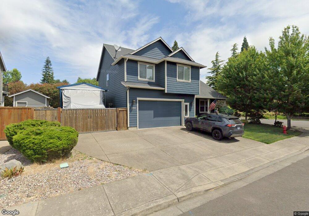
This home is located at 1243 Kirby Ave NE, Salem, OR 97303 and is currently estimated at $594,687, approximately $261 per square foot. 1243 Kirby Ave NE is a home located in Marion County with nearby schools including Forest Ridge Elementary School, Whiteaker Middle School, and McNary High School.
Ownership History
Date
Name
Owned For
Owner Type
Purchase Details
Closed on
Oct 12, 2009
Sold by
Capital Enterprises Llc
Bought by
Rice Jeremy D and Rice Elodia Elizabeth
Current Estimated Value
Home Financials for this Owner
Home Financials are based on the most recent Mortgage that was taken out on this home.
Original Mortgage
$257,478
Outstanding Balance
$167,961
Interest Rate
5.14%
Mortgage Type
VA
Estimated Equity
$426,726
Create a Home Valuation Report for This Property
The Home Valuation Report is an in-depth analysis detailing your home's value as well as a comparison with similar homes in the area
Home Values in the Area
Average Home Value in this Area
Purchase History
| Date | Buyer | Sale Price | Title Company |
|---|---|---|---|
| Rice Jeremy D | $291,457 | Fidelity Natl Title Co Of Or |
Source: Public Records
Mortgage History
| Date | Status | Borrower | Loan Amount |
|---|---|---|---|
| Open | Rice Jeremy D | $257,478 |
Source: Public Records
Tax History Compared to Growth
Tax History
| Year | Tax Paid | Tax Assessment Tax Assessment Total Assessment is a certain percentage of the fair market value that is determined by local assessors to be the total taxable value of land and additions on the property. | Land | Improvement |
|---|---|---|---|---|
| 2025 | $5,608 | $331,400 | -- | -- |
| 2024 | $5,608 | $321,750 | -- | -- |
| 2023 | $5,337 | $312,380 | $0 | $0 |
| 2022 | $5,021 | $303,290 | $0 | $0 |
| 2021 | $4,958 | $294,460 | $0 | $0 |
| 2020 | $4,652 | $285,890 | $0 | $0 |
| 2019 | $4,675 | $277,570 | $0 | $0 |
| 2018 | $4,740 | $0 | $0 | $0 |
| 2017 | $4,271 | $0 | $0 | $0 |
| 2016 | $4,098 | $0 | $0 | $0 |
| 2015 | $4,038 | $0 | $0 | $0 |
| 2014 | $3,882 | $0 | $0 | $0 |
Source: Public Records
Map
Nearby Homes
- 1545 Dale Ave NE
- 7945 June Reid Place NE
- 1545 Dale Ave
- 1319 St NE
- 1321 Oppek St NE
- Lot #2 Oppek St NE
- Lot 6 Oppek St NE
- Lot 5 Oppek St NE
- 7846 Matt Place NE
- 0 Wheatland (Parcel 063w23ac00800) Dr
- 754 Pinehurst Ave NE
- 7408 Kayla Shae Cir NE
- 1281 Prairie Grass Ave NE
- 7524 Shadowwood St NE
- 8295 Wheatland Rd N
- 1228 Bent Grass Ct NE
- 1158 Meadowridge St NE
- 674 Shannon Ct NE
- 1079 Northrup Ct NE
- 6986 9th Ct NE
- 1223 Kirby Ave NE
- 1203 Kirby Ave NE
- 7849 Timothy Ln NE
- 1242 Kirby Ave NE
- 1232 Kirby Ave NE
- 7830 Timothy Ln NE
- 1212 Kirby Ave NE
- 1193 Kirby Ave NE
- 1192 Kirby Ave NE
- 7850 Timothy Ln NE
- 1173 Kirby Ave NE
- 1182 Kirby Ave NE
- 1189 Harbour Ln NE
- 1163 Kirby Ave NE
- 1184 Maddy Ave NE
- 1184 Maddy Ave NE Unit 15) Av
- 1184 Maddy Ave NE
- 1172 Kirby Ave NE
- 1179 Harbour Ln NE
- 7790 Timothy Ln NE