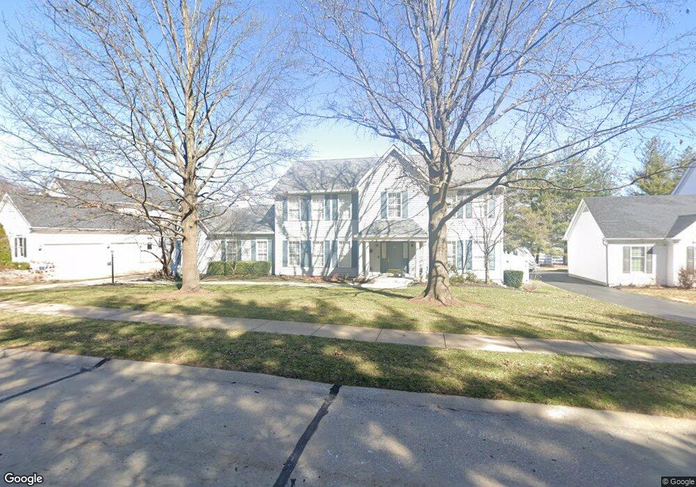
12433 Nicholas Ln Saint Louis, MO 63131
Estimated Value: $1,011,000 - $1,122,000
4
Beds
4
Baths
3,658
Sq Ft
$293/Sq Ft
Est. Value
About This Home
This home is located at 12433 Nicholas Ln, Saint Louis, MO 63131 and is currently estimated at $1,073,216, approximately $293 per square foot. 12433 Nicholas Ln is a home located in St. Louis County with nearby schools including Westchester Elementary School, North Kirkwood Middle School, and Kirkwood Senior High School.
Ownership History
Date
Name
Owned For
Owner Type
Purchase Details
Closed on
Dec 5, 2008
Sold by
Nicholson Ellen L and Nicholson Terrence M
Bought by
Nicholson Terrence M and Nicholson Ellen A Lawlor
Current Estimated Value
Purchase Details
Closed on
Jan 23, 2001
Sold by
Nicholson Ellen L and Nicholson Terrence M
Bought by
Nicholson Terrence M
Purchase Details
Closed on
Jan 22, 2001
Sold by
Nicholson Terrence M and Nicholson Ellen A
Bought by
Nicholson Ellen L
Create a Home Valuation Report for This Property
The Home Valuation Report is an in-depth analysis detailing your home's value as well as a comparison with similar homes in the area
Home Values in the Area
Average Home Value in this Area
Purchase History
| Date | Buyer | Sale Price | Title Company |
|---|---|---|---|
| Nicholson Terrence M | -- | None Available | |
| Nicholson Terrence M | -- | -- | |
| Nicholson Ellen L | -- | -- |
Source: Public Records
Tax History Compared to Growth
Tax History
| Year | Tax Paid | Tax Assessment Tax Assessment Total Assessment is a certain percentage of the fair market value that is determined by local assessors to be the total taxable value of land and additions on the property. | Land | Improvement |
|---|---|---|---|---|
| 2025 | $8,893 | $198,990 | $68,590 | $130,400 |
| 2024 | $8,893 | $153,940 | $49,400 | $104,540 |
| 2023 | $8,755 | $153,940 | $49,400 | $104,540 |
| 2022 | $7,539 | $123,500 | $49,400 | $74,100 |
| 2021 | $7,458 | $135,170 | $49,400 | $85,770 |
| 2020 | $7,368 | $117,310 | $45,600 | $71,710 |
| 2019 | $7,377 | $117,310 | $45,600 | $71,710 |
| 2018 | $7,669 | $109,440 | $26,940 | $82,500 |
| 2017 | $7,689 | $109,440 | $26,940 | $82,500 |
| 2016 | $7,343 | $105,850 | $23,140 | $82,710 |
| 2015 | $7,352 | $105,850 | $23,140 | $82,710 |
| 2014 | $6,563 | $92,300 | $9,820 | $82,480 |
Source: Public Records
Map
Nearby Homes
- 918 N Ballas Rd
- 12439 Springdale Ln Unit TBB
- 12841 Thornhill Ct
- 1029 Kinstern Dr
- 12224 TBB Roger Ln
- 1090 Kinstern Dr
- 12213 Brook Springs Ct
- 1824 Topping Rd
- The Hawthorne Plan at Ballas Ridge
- The Roclare II Plan at Ballas Ridge
- The Westchester IV Plan at Ballas Ridge
- The Nottingham II Plan at Ballas Ridge
- The Hawthorne II Plan at Ballas Ridge
- TBB
- TBB Ballas Ridge Roclare II
- TBB Ballas Ridge Hawthorne II
- 1126 Bopp Rd
- TBB Ballas Ridge Westchester IV
- TBB
- 12006 Montour Dr
- 12437 Nicholas Ln
- 12526 Ridgefield Dr
- 12534 Ridgefield Dr
- 12518 Ridgefield Dr
- 12425 Nicholas Ln
- 12441 Nicholas Ln
- 12510 Ridgefield Dr
- 12542 Ridgefield Dr
- 12445 Nicholas Ln
- 12421 Nicholas Ln
- 12523 Ridgefield Dr
- 12515 Ridgefield Dr
- 12475 Ridgefield Dr
- 1401 Ridgefield Dr
- 12417 Nicholas Ln
- 12442 Ridgefield Dr
- 12467 Ballas Meadows Dr
- 14282BBLT Ridgefield Dr
- 1428 Ridgefield Dr