Estimated Value: $566,000 - $659,000
5
Beds
4
Baths
2,864
Sq Ft
$213/Sq Ft
Est. Value
About This Home
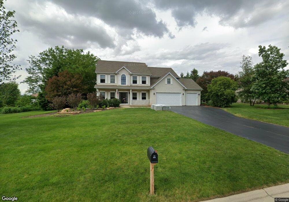
This home is located at 12435 Andrew St, Plano, IL 60545 and is currently estimated at $611,237, approximately $213 per square foot. 12435 Andrew St is a home located in Kendall County with nearby schools including Yorkville Grade School, Yorkville Intermediate School, and Yorkville Middle School.
Ownership History
Date
Name
Owned For
Owner Type
Purchase Details
Closed on
Dec 1, 2023
Sold by
Jernigan Thomas C and Jernigan Lisa M
Bought by
Jernigan Thomas C and Jernigan Lisa M
Current Estimated Value
Purchase Details
Closed on
Jun 3, 2005
Sold by
Montalbano Robert L and Montalbano Danielle M
Bought by
Jernigan Thomas C and Jernigan Lisa M
Home Financials for this Owner
Home Financials are based on the most recent Mortgage that was taken out on this home.
Original Mortgage
$450,000
Interest Rate
5.82%
Mortgage Type
Fannie Mae Freddie Mac
Purchase Details
Closed on
May 30, 2002
Sold by
Mccue Builders Inc
Bought by
Montalbano Robert L and Montalbano Danielle M
Home Financials for this Owner
Home Financials are based on the most recent Mortgage that was taken out on this home.
Original Mortgage
$240,000
Interest Rate
7%
Create a Home Valuation Report for This Property
The Home Valuation Report is an in-depth analysis detailing your home's value as well as a comparison with similar homes in the area
Home Values in the Area
Average Home Value in this Area
Purchase History
| Date | Buyer | Sale Price | Title Company |
|---|---|---|---|
| Jernigan Thomas C | -- | None Listed On Document | |
| Jernigan Thomas C | $475,000 | Chicago Title Insurance Co | |
| Montalbano Robert L | $323,000 | Law Title Insurance Co Inc |
Source: Public Records
Mortgage History
| Date | Status | Borrower | Loan Amount |
|---|---|---|---|
| Previous Owner | Jernigan Thomas C | $450,000 | |
| Previous Owner | Montalbano Robert L | $240,000 |
Source: Public Records
Tax History Compared to Growth
Tax History
| Year | Tax Paid | Tax Assessment Tax Assessment Total Assessment is a certain percentage of the fair market value that is determined by local assessors to be the total taxable value of land and additions on the property. | Land | Improvement |
|---|---|---|---|---|
| 2024 | $12,630 | $168,164 | $22,930 | $145,234 |
| 2023 | $11,654 | $149,572 | $20,395 | $129,177 |
| 2022 | $11,654 | $136,470 | $18,608 | $117,862 |
| 2021 | $11,116 | $128,033 | $17,458 | $110,575 |
| 2020 | $11,492 | $128,033 | $17,458 | $110,575 |
| 2019 | $11,378 | $124,095 | $16,741 | $107,354 |
| 2018 | $12,473 | $136,561 | $16,741 | $119,820 |
| 2017 | $12,040 | $124,146 | $15,219 | $108,927 |
| 2016 | $11,957 | $118,959 | $15,219 | $103,740 |
| 2015 | $11,337 | $107,406 | $13,097 | $94,309 |
| 2014 | -- | $94,727 | $12,000 | $82,727 |
| 2013 | -- | $95,136 | $13,409 | $81,727 |
Source: Public Records
Map
Nearby Homes
- 11948 Andrew St
- 11921 Andrew St
- Lot 11 Ashley Ln
- 4104 Dillon St
- 3742 Pope Ct Unit 7403
- 3707 Munson St
- 4311 Cummins St
- 3736 Munson St Unit 7332
- 4310 Klatt St
- 3839 Munson St Unit 7054
- 3649 Bailey St
- 3304 Alyssa St Unit 2A
- 1341 Carolyn Ct
- 1397 Carolyn Ct
- 3305 Paige St Unit 2A
- 114 Schmidt Ct
- 535 Alyssa St Unit 2A
- 531 Alyssa St
- 3928 Kristen Ct
- 215 Alexis St
- 12407 Andrew St
- 12434 Andrew St
- 12406 Andrew St
- 12462 Andrew St
- 12491 Andrew St
- 4110 Foli St
- 4114 Foli St
- 4106 Foli St
- 12379 Andrew St
- 4118 Foli St
- 12490 Andrew St
- 4102 Foli St
- 12378 Andrew St
- 4122 Foli St
- LOT 25 Andrew St
- LOT 12 Andrew Cir
- Lot 21 Andrew St
- Lot 12 Andrew St
- 33 Andrew
- Lot 20 Andrew St