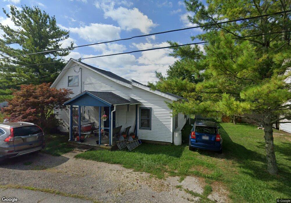
12437 State Route 56 W Mount Sterling, OH 43143
Estimated Value: $127,961 - $224,000
1
Bed
1
Bath
1,371
Sq Ft
$124/Sq Ft
Est. Value
About This Home
This home is located at 12437 State Route 56 W, Mount Sterling, OH 43143 and is currently estimated at $169,990, approximately $123 per square foot. 12437 State Route 56 W is a home located in Pickaway County with nearby schools including Westfall Elementary School, Westfall Middle School, and Westfall High School.
Ownership History
Date
Name
Owned For
Owner Type
Purchase Details
Closed on
Aug 28, 1995
Sold by
Longcoy Steven L
Bought by
Montgomery Douglas G and Montgomery Nancy L
Current Estimated Value
Home Financials for this Owner
Home Financials are based on the most recent Mortgage that was taken out on this home.
Original Mortgage
$33,950
Interest Rate
7.43%
Mortgage Type
New Conventional
Purchase Details
Closed on
May 24, 1991
Sold by
Howard Norman J
Bought by
Longcoy Steven L
Purchase Details
Closed on
Feb 1, 1985
Create a Home Valuation Report for This Property
The Home Valuation Report is an in-depth analysis detailing your home's value as well as a comparison with similar homes in the area
Home Values in the Area
Average Home Value in this Area
Purchase History
| Date | Buyer | Sale Price | Title Company |
|---|---|---|---|
| Montgomery Douglas G | $35,000 | -- | |
| Longcoy Steven L | $15,100 | -- | |
| -- | $17,500 | -- |
Source: Public Records
Mortgage History
| Date | Status | Borrower | Loan Amount |
|---|---|---|---|
| Closed | Montgomery Douglas G | $33,950 |
Source: Public Records
Tax History Compared to Growth
Tax History
| Year | Tax Paid | Tax Assessment Tax Assessment Total Assessment is a certain percentage of the fair market value that is determined by local assessors to be the total taxable value of land and additions on the property. | Land | Improvement |
|---|---|---|---|---|
| 2024 | -- | $29,070 | $5,920 | $23,150 |
| 2023 | $922 | $29,070 | $5,920 | $23,150 |
| 2022 | $787 | $21,370 | $4,700 | $16,670 |
| 2021 | $795 | $21,370 | $4,700 | $16,670 |
| 2020 | $796 | $21,370 | $4,700 | $16,670 |
| 2019 | $624 | $17,420 | $4,350 | $13,070 |
| 2018 | $639 | $17,420 | $4,350 | $13,070 |
| 2017 | $1,043 | $17,420 | $4,350 | $13,070 |
| 2016 | $609 | $16,280 | $4,000 | $12,280 |
| 2015 | $622 | $16,280 | $4,000 | $12,280 |
| 2014 | $628 | $16,280 | $4,000 | $12,280 |
| 2013 | $679 | $16,280 | $4,000 | $12,280 |
Source: Public Records
Map
Nearby Homes
- 12343 State Route 316
- 11821 State Route 56 W
- 0 Yankeetown Pike Unit 225019293
- 11744 Yankeetown Pike
- 15841 London Rd
- 21651 Hannawalt Rd
- 9141 Water St
- 8990 Water St
- 15561 Blain Rd
- 16270 Cook Yankeetown Rd NE
- 8187 Ohio 316
- 8713 State Route 207
- 500 Wingate Place N
- 16185 State Route 207
- 7700 Scioto-Darby Rd
- 67 W Columbus St
- 230 W Columbus St
- 223 W Main St
- 233 W Main St
- 60 N London St
- 12447 State Route 56 W
- 12413 State Route 56 W
- 12459 Ohio 56
- 18290 Five Points Pike
- 12424 State Route 56 W
- 12460 State Route 56 W
- 18324 Five Points Pike
- 12471 State Route 56 W
- 18280 Five Points Pike
- 12400 W State Route 56 W
- 18270 Five Points Pike
- 12379 State Route 56 W
- 12379 State Route 56 W
- 12385 State Route 56 W
- 18300 Five Points Pike
- 18310 Five Points Pike
- 18270 Five Points Pike
- 12433 State Route 316
- 12407 State Route 316
- 18334 Five Points Pike