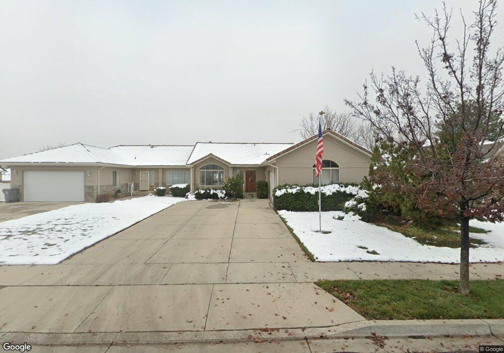
1244 Murdock Dr American Fork, UT 84003
Estimated Value: $565,003 - $679,000
3
Beds
3
Baths
1,642
Sq Ft
$376/Sq Ft
Est. Value
About This Home
This home is located at 1244 Murdock Dr, American Fork, UT 84003 and is currently estimated at $617,334, approximately $375 per square foot. 1244 Murdock Dr is a home located in Utah County with nearby schools including Deerfield Elementary School, Mountain Ridge Junior High School, and American Fork High School.
Ownership History
Date
Name
Owned For
Owner Type
Purchase Details
Closed on
Oct 6, 2016
Sold by
Plothow Roger H and Plothow Mary Gail
Bought by
Plothow Roger H and Plothow Mary Gail
Current Estimated Value
Purchase Details
Closed on
Dec 18, 2009
Sold by
Worsley Mary Gail
Bought by
Plothow Roger H and Plothow Mary Gail
Home Financials for this Owner
Home Financials are based on the most recent Mortgage that was taken out on this home.
Original Mortgage
$68,000
Interest Rate
4.88%
Mortgage Type
New Conventional
Purchase Details
Closed on
Nov 24, 1997
Sold by
A D C Corp
Bought by
Worsley Donald S and Worsley Mary Gail
Purchase Details
Closed on
Aug 5, 1997
Sold by
Folkman David I
Bought by
A D C Corp
Purchase Details
Closed on
Jun 23, 1997
Sold by
A D C Corp
Bought by
Folkman David I
Create a Home Valuation Report for This Property
The Home Valuation Report is an in-depth analysis detailing your home's value as well as a comparison with similar homes in the area
Home Values in the Area
Average Home Value in this Area
Purchase History
| Date | Buyer | Sale Price | Title Company |
|---|---|---|---|
| Plothow Roger H | -- | None Available | |
| Plothow Roger H | -- | Select Title Insurance Agen | |
| Worsley Donald S | -- | -- | |
| A D C Corp | -- | -- | |
| Folkman David I | -- | -- |
Source: Public Records
Mortgage History
| Date | Status | Borrower | Loan Amount |
|---|---|---|---|
| Closed | Plothow Roger H | $68,000 |
Source: Public Records
Tax History
| Year | Tax Paid | Tax Assessment Tax Assessment Total Assessment is a certain percentage of the fair market value that is determined by local assessors to be the total taxable value of land and additions on the property. | Land | Improvement |
|---|---|---|---|---|
| 2025 | $2,642 | $294,140 | -- | -- |
| 2024 | $2,445 | $293,535 | $0 | $0 |
| 2023 | $2,445 | $287,980 | $0 | $0 |
| 2022 | $2,218 | $257,840 | $0 | $0 |
| 2021 | $1,986 | $360,600 | $105,000 | $255,600 |
| 2020 | $1,932 | $340,200 | $105,000 | $235,200 |
| 2019 | $1,733 | $315,600 | $105,000 | $210,600 |
| 2018 | $1,812 | $315,600 | $105,000 | $210,600 |
| 2017 | $1,759 | $165,330 | $0 | $0 |
| 2016 | $1,671 | $145,915 | $0 | $0 |
| 2015 | $1,699 | $140,800 | $0 | $0 |
| 2014 | $1,568 | $128,150 | $0 | $0 |
Source: Public Records
Map
Nearby Homes
- 9587 N 4500 W
- 1125 N 1270 E
- 9752 N Dorchester Dr
- 4675 W Ferguson Way
- 4552 W Windsor Cir
- 4531 W Cambridge Dr
- 1089 N 950 E
- 1058 N 930 E Unit 64
- 1077 N 950 E
- 9506 N 4000 W
- 1045 N 930 E Unit 58
- 4979 W Willowbank Dr
- 4968 W Evergreen Ln
- 9481 N 3830 W
- 5061 W Evergreen Ln
- 3810 W Valley View Dr
- 9547 N Canyon Rd
- 4956 W Gallatin Way
- 4198 W Sage Rd N
- 5034 W Green Ash Ln
- 1226 Murdock Dr
- 1246 Murdock Dr
- 1224 Murdock Dr
- 1233 E 1350 N
- 1233 E 1350 N Unit 44
- 1231 E 1350 N
- 1231 E 1350 N Unit 43
- 1245 E 1350 N
- 1245 E 1350 N Unit TWIN
- 1272 Murdock Dr
- 1229 E 1350 N
- 1229 E 1350 N Unit 42
- 1247 E 1350 N Unit 46
- 1247 E 1350 N
- 1208 Murdock Dr
- 1208 Murdock Dr Unit 18
- 1221 Murdock Dr
- 1249 Murdock Dr
- 1267 Murdock Dr
- 1227 E 1350 N
Your Personal Tour Guide
Ask me questions while you tour the home.