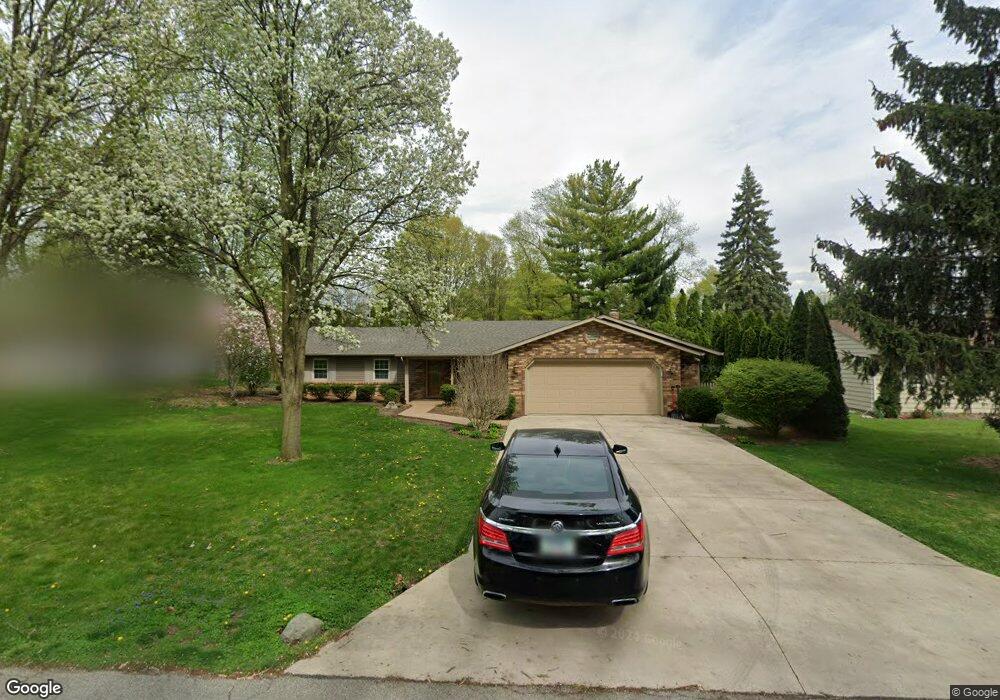
1244 Pinehurst Dr Fort Wayne, IN 46815
North Anthony NeighborhoodEstimated Value: $238,594 - $268,000
2
Beds
2
Baths
3,480
Sq Ft
$73/Sq Ft
Est. Value
About This Home
This home is located at 1244 Pinehurst Dr, Fort Wayne, IN 46815 and is currently estimated at $253,399, approximately $72 per square foot. 1244 Pinehurst Dr is a home located in Allen County with nearby schools including New Haven Primary School, New Haven Intermediate School, and New Haven High School.
Ownership History
Date
Name
Owned For
Owner Type
Purchase Details
Closed on
Sep 24, 2019
Sold by
Jehl John P and Jehl Victoria L
Bought by
Tobey Michael R and Tobey Charlotte A
Current Estimated Value
Home Financials for this Owner
Home Financials are based on the most recent Mortgage that was taken out on this home.
Original Mortgage
$147,820
Outstanding Balance
$128,348
Interest Rate
3.5%
Mortgage Type
New Conventional
Estimated Equity
$125,051
Create a Home Valuation Report for This Property
The Home Valuation Report is an in-depth analysis detailing your home's value as well as a comparison with similar homes in the area
Home Values in the Area
Average Home Value in this Area
Purchase History
| Date | Buyer | Sale Price | Title Company |
|---|---|---|---|
| Tobey Michael R | $160,000 | Trademark Title |
Source: Public Records
Mortgage History
| Date | Status | Borrower | Loan Amount |
|---|---|---|---|
| Open | Tobey Michael R | $147,820 |
Source: Public Records
Tax History
| Year | Tax Paid | Tax Assessment Tax Assessment Total Assessment is a certain percentage of the fair market value that is determined by local assessors to be the total taxable value of land and additions on the property. | Land | Improvement |
|---|---|---|---|---|
| 2025 | $2,215 | $215,100 | $44,100 | $171,000 |
| 2024 | $1,976 | $221,500 | $16,700 | $204,800 |
| 2022 | $1,664 | $166,400 | $16,700 | $149,700 |
| 2021 | $1,534 | $153,400 | $16,700 | $136,700 |
| 2020 | $1,454 | $145,400 | $16,700 | $128,700 |
| 2019 | $1,420 | $142,000 | $16,700 | $125,300 |
| 2018 | $2,804 | $140,200 | $16,700 | $123,500 |
| 2017 | $2,414 | $120,700 | $16,700 | $104,000 |
| 2016 | $2,218 | $110,900 | $16,700 | $94,200 |
| 2014 | $2,138 | $106,900 | $16,700 | $90,200 |
| 2013 | $2,048 | $102,400 | $16,700 | $85,700 |
Source: Public Records
Map
Nearby Homes
- 2521 Bolton Dr
- 2818 1/2 Reed Rd
- 1416 Lofton Way
- 2927 Woodstock Ct
- 2923 Inwood Dr
- 2426 White Oak Ave
- 2425 White Oak Ave
- 2412 Hobson Rd
- 6038 Monarch Dr
- 3410 Charlotte Ave
- 2611 Neptunes Crossing
- 5722 Port Royal
- 2808 Nordholme Ave
- 2716 White Oak Ave
- 5723 Port Royal
- 1304 Ardsley Ct
- 5720 Bayside Dr
- 1208 Fairview Ave
- 3303 Walden Run
- 6113 Millhollow Ln
- 1228 Pinehurst Dr
- 1310 Pinehurst Dr
- 1307 Pinevalley Dr
- 1319 Pinevalley Dr
- 1225 Pinevalley Dr
- 1314 Pinehurst Dr
- 1220 Pinehurst Dr
- 1241 Pinehurst Dr
- 1309 Pinehurst Dr
- 1331 Pinevalley Dr
- 1213 Pinevalley Dr
- 1316 Pinehurst Dr
- 1221 Pinehurst Dr
- 1210 Pinehurst Dr
- 1317 Pinehurst Dr
- 1341 Pinevalley Dr
- 000 Pine Valley Dr
- 1209 Pine Valley Dr
- 1308 Pinevalley Dr
- 1201 Pinevalley Dr
Your Personal Tour Guide
Ask me questions while you tour the home.