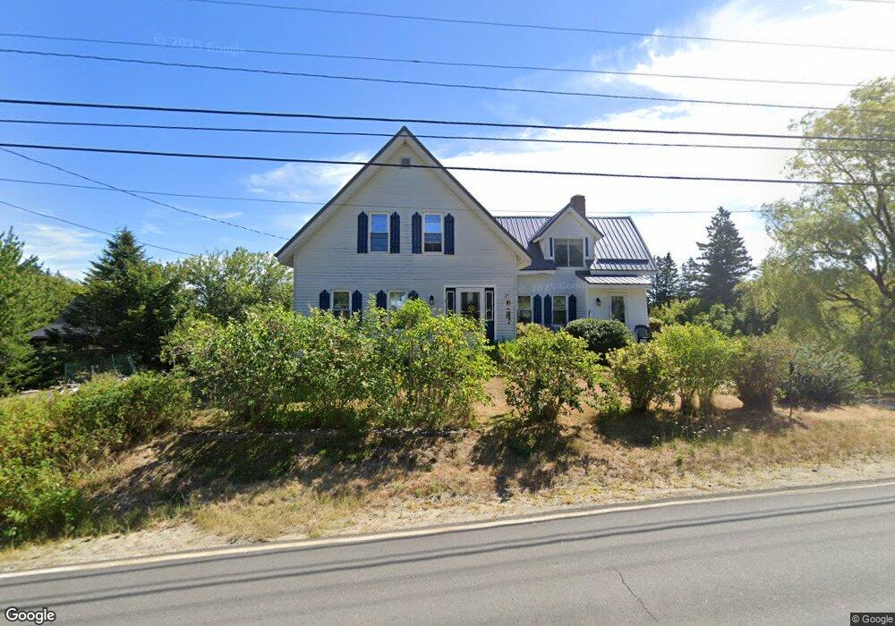
1244 Port Rd MacHiasport, ME 04655
Estimated Value: $214,000 - $385,000
3
Beds
2
Baths
1,569
Sq Ft
$187/Sq Ft
Est. Value
About This Home
This home is located at 1244 Port Rd, MacHiasport, ME 04655 and is currently estimated at $293,795, approximately $187 per square foot. 1244 Port Rd is a home with nearby schools including Fort O'Brien School.
Ownership History
Date
Name
Owned For
Owner Type
Purchase Details
Closed on
Dec 23, 2022
Sold by
Howland Joyce P
Bought by
Howald Joyce P
Current Estimated Value
Home Financials for this Owner
Home Financials are based on the most recent Mortgage that was taken out on this home.
Original Mortgage
$360,000
Outstanding Balance
$351,251
Interest Rate
8.08%
Mortgage Type
FHA
Estimated Equity
-$57,456
Create a Home Valuation Report for This Property
The Home Valuation Report is an in-depth analysis detailing your home's value as well as a comparison with similar homes in the area
Home Values in the Area
Average Home Value in this Area
Purchase History
| Date | Buyer | Sale Price | Title Company |
|---|---|---|---|
| Howald Joyce P | -- | None Available |
Source: Public Records
Mortgage History
| Date | Status | Borrower | Loan Amount |
|---|---|---|---|
| Open | Howald Joyce P | $360,000 |
Source: Public Records
Tax History Compared to Growth
Tax History
| Year | Tax Paid | Tax Assessment Tax Assessment Total Assessment is a certain percentage of the fair market value that is determined by local assessors to be the total taxable value of land and additions on the property. | Land | Improvement |
|---|---|---|---|---|
| 2024 | $2,111 | $162,400 | $65,060 | $97,340 |
| 2023 | $1,857 | $147,370 | $56,060 | $91,310 |
| 2022 | $1,559 | $126,760 | $42,200 | $84,560 |
| 2021 | $1,235 | $113,270 | $42,200 | $71,070 |
| 2020 | $1,416 | $113,270 | $42,200 | $71,070 |
| 2019 | $1,182 | $68,707 | $10,182 | $58,525 |
| 2018 | $1,271 | $68,707 | $10,182 | $58,525 |
| 2017 | $1,202 | $68,707 | $10,182 | $58,525 |
| 2016 | $1,202 | $68,707 | $10,182 | $58,525 |
| 2015 | $1,250 | $68,707 | $10,182 | $58,525 |
| 2014 | $1,250 | $68,707 | $10,182 | $58,525 |
| 2013 | $1,244 | $68,707 | $10,182 | $58,525 |
Source: Public Records
Map
Nearby Homes
- 1323 Port Rd
- 19 Yoho Head Rd
- 47 Yoho Head Rd
- 1 Puffins Ln
- MarkayEast Puffins Ln
- 14 Overlook Ln
- 246 Marsh Stream Ln
- 576 Port Rd
- Lot 95 N Duck Cove Rd
- Lot2A-2 Holway Rd
- 2-2A-001-A Holway Point Rd
- 604 Duck Cove Rd
- 366 Port Rd
- Lot #139 Duck Cove Rd
- 37 Corn Hill Rd
- 4-28 Old Town Rd Old County Rd Rd
- 070 Bobcat Path
- 787 Cutler Rd
- 780 Cutler Rd
- 406 W Kennebec Rd