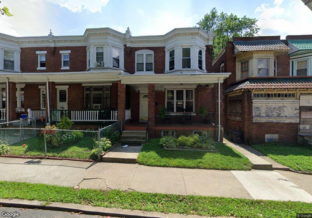
1245 Langham Ave Camden, NJ 08103
Parkside NeighborhoodEstimated Value: $139,000 - $180,000
--
Bed
--
Bath
1,301
Sq Ft
$117/Sq Ft
Est. Value
About This Home
This home is located at 1245 Langham Ave, Camden, NJ 08103 and is currently estimated at $152,653, approximately $117 per square foot. 1245 Langham Ave is a home located in Camden County with nearby schools including Camden High School and Freedom Prep Charter School.
Ownership History
Date
Name
Owned For
Owner Type
Purchase Details
Closed on
Apr 3, 2023
Sold by
Chatman Michelle
Bought by
Deoliveira Ricardo and Dealbuquerque Silvana
Current Estimated Value
Purchase Details
Closed on
Jan 17, 2000
Sold by
Pnc Bank
Bought by
Grimes Fay H
Purchase Details
Closed on
Jun 4, 1996
Sold by
Stricklin Walter B
Bought by
Singleton Anganetta
Home Financials for this Owner
Home Financials are based on the most recent Mortgage that was taken out on this home.
Original Mortgage
$37,000
Interest Rate
8.21%
Create a Home Valuation Report for This Property
The Home Valuation Report is an in-depth analysis detailing your home's value as well as a comparison with similar homes in the area
Home Values in the Area
Average Home Value in this Area
Purchase History
| Date | Buyer | Sale Price | Title Company |
|---|---|---|---|
| Deoliveira Ricardo | $60,000 | Infinity Title | |
| Deoliveira Ricardo | $60,000 | Infinity Title | |
| Grimes Fay H | $24,900 | -- | |
| Singleton Anganetta | $38,000 | -- |
Source: Public Records
Mortgage History
| Date | Status | Borrower | Loan Amount |
|---|---|---|---|
| Previous Owner | Singleton Anganetta | $37,000 |
Source: Public Records
Tax History Compared to Growth
Tax History
| Year | Tax Paid | Tax Assessment Tax Assessment Total Assessment is a certain percentage of the fair market value that is determined by local assessors to be the total taxable value of land and additions on the property. | Land | Improvement |
|---|---|---|---|---|
| 2025 | $2,197 | $62,000 | $11,900 | $50,100 |
| 2024 | $2,124 | $62,000 | $11,900 | $50,100 |
| 2023 | $2,124 | $62,000 | $11,900 | $50,100 |
| 2022 | $2,084 | $62,000 | $11,900 | $50,100 |
| 2021 | $1,970 | $62,000 | $11,900 | $50,100 |
| 2020 | $1,972 | $62,000 | $11,900 | $50,100 |
| 2019 | $1,888 | $62,000 | $11,900 | $50,100 |
| 2018 | $1,878 | $62,000 | $11,900 | $50,100 |
| 2017 | $1,832 | $62,000 | $11,900 | $50,100 |
| 2016 | $1,774 | $62,000 | $11,900 | $50,100 |
| 2015 | $1,707 | $62,000 | $11,900 | $50,100 |
| 2014 | $1,667 | $62,000 | $11,900 | $50,100 |
Source: Public Records
Map
Nearby Homes
- 1261 Kenwood Ave
- 1249 Kenwood Ave
- 1361 Kaighns Ave
- 1268 Kenwood Ave
- 1238 Haddon Ave
- 1367 Kenwood Ave
- 1213 Empire Ave
- 1224 Empire Ave
- 1386 Haddon Ave
- 1407 Bradley Ave
- 1243 Magnolia Ave
- 1510 Wildwood Ave
- 1411 Bradley Ave
- 1266 Magnolia Ave
- 1113 Empire Ave
- 1433 Haddon Ave
- 1327 Lansdowne Ave
- 1361 Park Blvd
- 1371 Park Blvd
- 1263 Lansdowne Ave
- 1247 Langham Ave
- 1243 Langham Ave
- 1239 Langham Ave
- 1249 Langham Ave
- 1237 Langham Ave
- 1251 Langham Ave
- 1235 Langham Ave
- 1253 Langham Ave
- 1233 Langham Ave
- 1248 Kenwood Ave
- 1250 Kenwood Ave
- 1246 Kenwood Ave
- 1252 Kenwood Ave
- 1244 Kenwood Ave
- 1254 Kenwood Ave
- 1255 Langham Ave
- 1231 Langham Ave
- 1242 Kenwood Ave
- 1256 Kenwood Ave
- 1258 Kenwood Ave