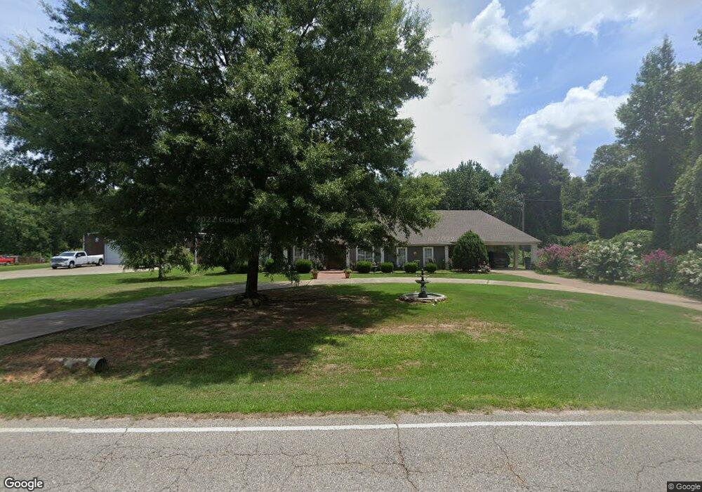
12453 Frank Lary Rd Northport, AL 35475
Estimated Value: $412,000 - $550,000
3
Beds
3
Baths
3,131
Sq Ft
$150/Sq Ft
Est. Value
About This Home
This home is located at 12453 Frank Lary Rd, Northport, AL 35475 and is currently estimated at $470,978, approximately $150 per square foot. 12453 Frank Lary Rd is a home located in Tuscaloosa County with nearby schools including Huntington Place Elementary School, Echols Middle School, and Tuscaloosa County High School.
Ownership History
Date
Name
Owned For
Owner Type
Purchase Details
Closed on
May 15, 2008
Sold by
Plowman Jeffrey J
Bought by
Oswalt Phillip
Current Estimated Value
Purchase Details
Closed on
Feb 24, 2005
Sold by
Martin Mark
Bought by
Plowman Jeffrey J
Home Financials for this Owner
Home Financials are based on the most recent Mortgage that was taken out on this home.
Original Mortgage
$145,000
Interest Rate
5.09%
Mortgage Type
Purchase Money Mortgage
Create a Home Valuation Report for This Property
The Home Valuation Report is an in-depth analysis detailing your home's value as well as a comparison with similar homes in the area
Home Values in the Area
Average Home Value in this Area
Purchase History
| Date | Buyer | Sale Price | Title Company |
|---|---|---|---|
| Oswalt Phillip | $280,000 | -- | |
| Plowman Jeffrey J | $180,000 | -- |
Source: Public Records
Mortgage History
| Date | Status | Borrower | Loan Amount |
|---|---|---|---|
| Previous Owner | Plowman Jeffrey J | $145,000 |
Source: Public Records
Tax History Compared to Growth
Tax History
| Year | Tax Paid | Tax Assessment Tax Assessment Total Assessment is a certain percentage of the fair market value that is determined by local assessors to be the total taxable value of land and additions on the property. | Land | Improvement |
|---|---|---|---|---|
| 2024 | $1,526 | $86,100 | $4,120 | $81,980 |
| 2023 | $1,526 | $79,960 | $4,120 | $75,840 |
| 2022 | $1,242 | $70,760 | $4,120 | $66,640 |
| 2021 | $1,226 | $69,900 | $4,120 | $65,780 |
| 2020 | $1,048 | $30,160 | $2,060 | $28,100 |
| 2019 | $1,071 | $30,760 | $2,060 | $28,700 |
| 2018 | $1,071 | $30,760 | $2,060 | $28,700 |
| 2017 | $1,036 | $0 | $0 | $0 |
| 2016 | $1,001 | $0 | $0 | $0 |
| 2015 | $1,022 | $0 | $0 | $0 |
| 2014 | $1,022 | $29,430 | $2,060 | $27,370 |
Source: Public Records
Map
Nearby Homes
- 2996 Meadow St
- 13602 Cranberry Dr
- 11504 Forest Glen Blvd
- 3012 Birch Way
- 13563 Date St
- 13711 Elderberry Ln
- 12012 Arlington Ave
- 11429 Magnolia Wood Ave
- 11406 Magnolia Wood Ave
- 13600 Date St
- 3701 Greenbrook Dr
- 13963 Prince William Way
- 11313 Evergreen Ave
- 11113 Dexter Ave
- 11445 Canetuck Ln
- 13822 Margaret Way
- 3721 Greenbrook Dr
- 13519 Margaret Way
- 000 Frank Lary Rd
- 0 Frank Lary Rd Unit 169714
- 12265 Frank Lary Rd
- 12545 Frank Lary Rd
- 12450 Frank Lary Rd
- 12440 Frank Lary Rd
- 11813 Baseball Dr
- 12590 Frank Lary Rd
- 12590 Frank Lary Rd
- 12595 Frank Lary Rd
- 12724 Frank Lary Rd
- 12395 Frank Lary Rd
- 12784 Frank Lary Rd
- 12775 Frank Lary Rd
- 11784 Baseball Dr
- 12844 Frank Lary Rd
- 12115 Frank Lary Rd
- 12675 Frank Lary Rd
- 12904 Frank Lary Rd
- 3300 Mitt Lary Rd
- 13595 Apple Ln
- 13613 Apple Ln