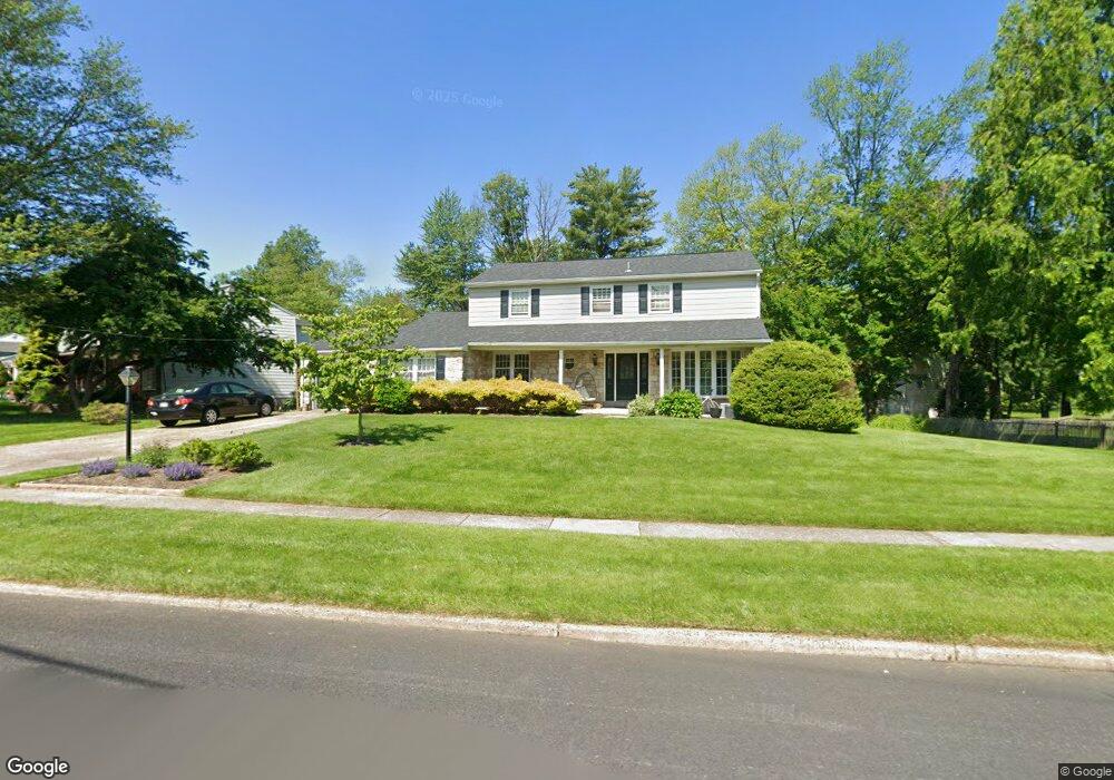
1246 Dundee Dr Dresher, PA 19025
Estimated Value: $623,782 - $729,000
4
Beds
3
Baths
2,670
Sq Ft
$253/Sq Ft
Est. Value
About This Home
This home is located at 1246 Dundee Dr, Dresher, PA 19025 and is currently estimated at $675,946, approximately $253 per square foot. 1246 Dundee Dr is a home located in Montgomery County with nearby schools including Thomas Fitzwater Elementary School, Sandy Run Middle School, and Upper Dublin High School.
Ownership History
Date
Name
Owned For
Owner Type
Purchase Details
Closed on
Oct 31, 2011
Sold by
Rosenthal Martin Harold and Rosenthal Brett S
Bought by
Begley Erin and Ellis David P
Current Estimated Value
Home Financials for this Owner
Home Financials are based on the most recent Mortgage that was taken out on this home.
Original Mortgage
$274,500
Outstanding Balance
$187,092
Interest Rate
4.01%
Estimated Equity
$488,854
Create a Home Valuation Report for This Property
The Home Valuation Report is an in-depth analysis detailing your home's value as well as a comparison with similar homes in the area
Home Values in the Area
Average Home Value in this Area
Purchase History
| Date | Buyer | Sale Price | Title Company |
|---|---|---|---|
| Begley Erin | $305,000 | None Available |
Source: Public Records
Mortgage History
| Date | Status | Borrower | Loan Amount |
|---|---|---|---|
| Open | Begley Erin | $274,500 |
Source: Public Records
Tax History Compared to Growth
Tax History
| Year | Tax Paid | Tax Assessment Tax Assessment Total Assessment is a certain percentage of the fair market value that is determined by local assessors to be the total taxable value of land and additions on the property. | Land | Improvement |
|---|---|---|---|---|
| 2025 | $10,074 | $206,550 | $58,770 | $147,780 |
| 2024 | $10,074 | $206,550 | $58,770 | $147,780 |
| 2023 | $9,838 | $206,550 | $58,770 | $147,780 |
| 2022 | $9,623 | $206,550 | $58,770 | $147,780 |
| 2021 | $9,383 | $206,550 | $58,770 | $147,780 |
| 2020 | $9,112 | $206,550 | $58,770 | $147,780 |
| 2019 | $8,960 | $206,550 | $58,770 | $147,780 |
| 2018 | $8,959 | $206,550 | $58,770 | $147,780 |
| 2017 | $8,633 | $206,550 | $58,770 | $147,780 |
| 2016 | $8,552 | $206,550 | $58,770 | $147,780 |
| 2015 | $8,079 | $206,550 | $58,770 | $147,780 |
| 2014 | $8,079 | $206,550 | $58,770 | $147,780 |
Source: Public Records
Map
Nearby Homes
- 3225 Burn Brae Dr
- 1212 Duncan Dr
- 1371 Fitzwatertown Rd
- 309 Woodside Cir
- 2933 Susquehanna Rd
- 1521 Coulon Rd
- 2806 Anzac Ave
- 2750 Turner Ave
- 2653 Barnes Ave
- 2637 Woodland Rd
- 3012 Lincoln Ave
- 2803 Lamott Ave
- 1710 Twining Rd
- 3020 Old Welsh Rd
- 1503 Lindbergh Ave
- 1403 Birchwood Ave
- 1567 Lindbergh Ave
- 2814 Old Welsh Rd
- 1380 Harris Rd
- 541 Cardinal Dr
- 1240 Dundee Dr Unit 51
- 3204 Burn Brae Dr
- 3208 Burn Brae Dr
- 3212 Burn Brae Dr
- 1236 Dundee Dr
- 3156 Burn Brae Dr
- 1247 Dundee Dr
- 1243 Dundee Dr
- 3216 Burn Brae Dr
- 1239 Dundee Dr
- 1232 Dundee Dr
- 3150 Burn Brae Dr
- 1235 Dundee Dr
- 3220 Burn Brae Dr
- 1228 Dundee Dr
- 3205 Burn Brae Dr
- 3209 Burn Brae Dr
- 3213 Burn Brae Dr
- 1231 Dundee Dr
- 3146 Burn Brae Dr