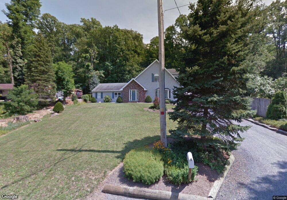
1246 S 10th St Emmaus, PA 18049
Estimated Value: $322,000 - $442,000
2
Beds
3
Baths
2,104
Sq Ft
$188/Sq Ft
Est. Value
About This Home
This home is located at 1246 S 10th St, Emmaus, PA 18049 and is currently estimated at $396,279, approximately $188 per square foot. 1246 S 10th St is a home located in Lehigh County with nearby schools including Lincoln Elementary School, Lower Macungie Middle School, and Emmaus High School.
Ownership History
Date
Name
Owned For
Owner Type
Purchase Details
Closed on
May 20, 2002
Sold by
Persing Jeanne P
Bought by
The Dale B & Jeanne P Persing Revocable
Current Estimated Value
Purchase Details
Closed on
Oct 17, 1985
Sold by
Beller Dwayne G and Sell Georgiana I
Bought by
Blackman Bruce A and Blackman Terry L
Purchase Details
Closed on
Aug 19, 1980
Bought by
Beller Dwayne G and Sell Georgiana I
Create a Home Valuation Report for This Property
The Home Valuation Report is an in-depth analysis detailing your home's value as well as a comparison with similar homes in the area
Home Values in the Area
Average Home Value in this Area
Purchase History
| Date | Buyer | Sale Price | Title Company |
|---|---|---|---|
| The Dale B & Jeanne P Persing Revocable | -- | -- | |
| Blackman Bruce A | $52,000 | -- | |
| Beller Dwayne G | -- | -- |
Source: Public Records
Tax History Compared to Growth
Tax History
| Year | Tax Paid | Tax Assessment Tax Assessment Total Assessment is a certain percentage of the fair market value that is determined by local assessors to be the total taxable value of land and additions on the property. | Land | Improvement |
|---|---|---|---|---|
| 2025 | $8,067 | $229,000 | $38,300 | $190,700 |
| 2024 | $7,389 | $229,000 | $38,300 | $190,700 |
| 2023 | $7,245 | $229,000 | $38,300 | $190,700 |
| 2022 | $7,006 | $229,000 | $190,700 | $38,300 |
| 2021 | $6,831 | $229,000 | $38,300 | $190,700 |
| 2020 | $6,772 | $229,000 | $38,300 | $190,700 |
| 2019 | $6,591 | $229,000 | $38,300 | $190,700 |
| 2018 | $6,343 | $229,000 | $38,300 | $190,700 |
| 2017 | $6,147 | $229,000 | $38,300 | $190,700 |
| 2016 | -- | $229,000 | $38,300 | $190,700 |
| 2015 | -- | $229,000 | $38,300 | $190,700 |
| 2014 | -- | $229,000 | $38,300 | $190,700 |
Source: Public Records
Map
Nearby Homes
- 97 Chestnut Hill Rd
- 339 Delong Ave Unit 343
- 659 Broad St
- 4160 Newport Dr
- 618 Broad St
- 4109 Eveningstar Rd
- 3430 Gentlewind Way Unit IC 109
- 521 Wood St
- 657 Walnut St
- 569 Chestnut St Unit 571
- 3989 Mink Rd
- 4088 Eveningstar Rd
- 3810 Allen St
- 3623 Daylily Dr
- 4389 Taviston Ct E
- 5160 Maple Ridge Way
- 543 Long St
- 4481 Linda Ln
- 4285 Taviston Ct E
- 5065 Maple Ridge Way
- 540 Oakhill Rd
- 1254 S 10th St
- 0000 Torino Model
- 0000 Hawthorne Model
- 0000 Montclair Model
- 0000 Fairfield Model
- 0000 Montclair Grand Model
- 0000 Prescott Grande Model
- 0000 Prescott Model
- 0000 Bancroft Model
- 0000 Swarthmore Model
- 0000 Athens Model
- 0000 Cambridge To Be Built
- 0 Cambridge To Be Built Unit 5369052
- 0 Prescott Model Unit 5371241
- 0 Bancroft Model Unit 5370956
- 0 Swarthmore Model Unit 5370944
- 0 Athens Model Unit 5370644
- 0 Montclair Model Unit 5371332
- 0 Hawthorne Model Unit 5371404