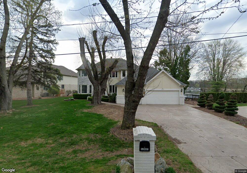
12467 Margaret Dr Fenton, MI 48430
Estimated Value: $1,553,000 - $1,832,000
3
Beds
4
Baths
4,578
Sq Ft
$368/Sq Ft
Est. Value
About This Home
This home is located at 12467 Margaret Dr, Fenton, MI 48430 and is currently estimated at $1,686,941, approximately $368 per square foot. 12467 Margaret Dr is a home located in Genesee County with nearby schools including West Shore Elementary School, Torrey Hill Intermediate School, and Lake Fenton Middle School.
Ownership History
Date
Name
Owned For
Owner Type
Purchase Details
Closed on
Dec 9, 2024
Sold by
Mukkamala Srinivas and Kulkarni Nita M
Bought by
Mukkamala Revocable Living Trust and Mukkamala
Current Estimated Value
Purchase Details
Closed on
Aug 24, 2007
Sold by
Baki Judith L and Baki Fouad
Bought by
Mukkamala Srinivas and Kulkarni Nita M
Home Financials for this Owner
Home Financials are based on the most recent Mortgage that was taken out on this home.
Original Mortgage
$756,000
Interest Rate
6.49%
Mortgage Type
Purchase Money Mortgage
Create a Home Valuation Report for This Property
The Home Valuation Report is an in-depth analysis detailing your home's value as well as a comparison with similar homes in the area
Home Values in the Area
Average Home Value in this Area
Purchase History
| Date | Buyer | Sale Price | Title Company |
|---|---|---|---|
| Mukkamala Revocable Living Trust | -- | None Listed On Document | |
| Mukkamala Srinivas | $945,000 | Select T |
Source: Public Records
Mortgage History
| Date | Status | Borrower | Loan Amount |
|---|---|---|---|
| Previous Owner | Mukkamala Srinivas | $756,000 |
Source: Public Records
Tax History Compared to Growth
Tax History
| Year | Tax Paid | Tax Assessment Tax Assessment Total Assessment is a certain percentage of the fair market value that is determined by local assessors to be the total taxable value of land and additions on the property. | Land | Improvement |
|---|---|---|---|---|
| 2025 | $16,255 | $843,500 | $0 | $0 |
| 2024 | $5,994 | $836,500 | $0 | $0 |
| 2023 | $5,718 | $763,200 | $0 | $0 |
| 2022 | $15,332 | $679,600 | $0 | $0 |
| 2021 | $15,420 | $659,800 | $0 | $0 |
| 2020 | $5,230 | $646,500 | $0 | $0 |
| 2019 | $5,126 | $591,400 | $0 | $0 |
| 2018 | $14,227 | $482,300 | $0 | $0 |
| 2017 | $13,626 | $487,900 | $0 | $0 |
| 2016 | $13,497 | $472,600 | $0 | $0 |
| 2015 | $13,513 | $430,000 | $0 | $0 |
| 2014 | $4,727 | $435,900 | $0 | $0 |
| 2012 | -- | $408,800 | $408,800 | $0 |
Source: Public Records
Map
Nearby Homes
- 2410 Torrey Grove Ct Unit 12
- 2234 Toledo St
- 12333 Saint Andrews Way Unit 86
- 12410 Woodhull Landing
- 2414 Cranewood Dr
- 12364 Saint Andrews Way Unit 66
- 12147 Torrey Rd
- 13111 Harbor Landings Dr Unit 46
- 3130 Harbor Pointe Cir Unit 64
- 3129 Harbor Pointe Cir
- VL Crane Crane Rd
- 13167 Harbor Landings Dr
- 13163 Harbor Landings Dr Unit 112
- 3127 Harbor Pointe Cir
- 2361 Golden Shore Dr
- 2369 Golden Shores Dr
- 13200 Log Cabin Point
- 2294 Sonora Dr
- 12237 Dalhart Dr
- 13293 Lake Shore Dr
- 12475 Margaret Dr
- 12459 Margaret Dr
- 12483 Margaret Dr
- 12447 Margaret Dr
- 12470 Margaret Dr
- 12491 Margaret Dr
- 12491 Margaret Dr
- 12491 Margaret Dr
- 12491 Margaret Dr
- 12460 Margaret Dr
- 12482 Margaret Dr
- 12437 Margaret Dr
- 12452 Margaret Dr
- 12488 Margaret Dr
- 12444 Margaret Dr
- 12499 Margaret Dr
- 12436 Margaret Dr
- 12427 Margaret Dr
- 2430 Torrey Grove Ct
- 12498 Margaret Dr