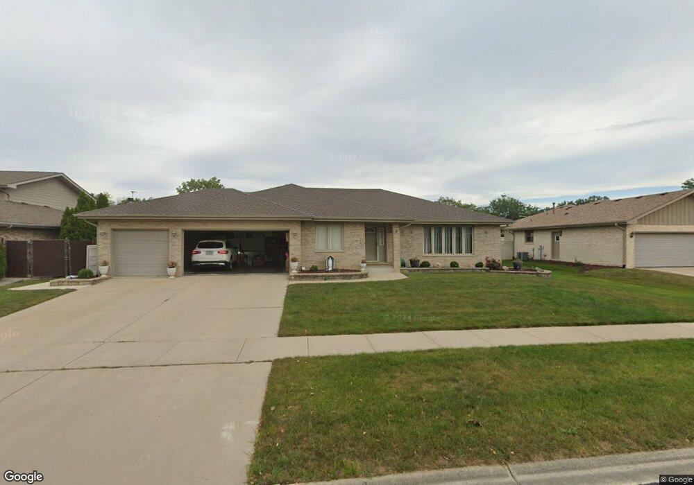
1248 Tralee Ln Lockport, IL 60441
Estimated Value: $381,000 - $540,000
Studio
1
Bath
2,505
Sq Ft
$190/Sq Ft
Est. Value
About This Home
This home is located at 1248 Tralee Ln, Lockport, IL 60441 and is currently estimated at $475,027, approximately $189 per square foot. 1248 Tralee Ln is a home located in Will County with nearby schools including Walsh Elementary School, Ludwig Elementary School, and Reed Elementary School.
Ownership History
Date
Name
Owned For
Owner Type
Purchase Details
Closed on
Feb 18, 2002
Sold by
Uher Robert J and Uher Nancy J
Bought by
Veltri Eugenio F and Veltri Lisa A
Current Estimated Value
Home Financials for this Owner
Home Financials are based on the most recent Mortgage that was taken out on this home.
Original Mortgage
$140,000
Outstanding Balance
$57,110
Interest Rate
6.87%
Estimated Equity
$417,917
Purchase Details
Closed on
Jun 2, 1999
Sold by
Nlsb
Bought by
Uher Robert J and Uher Nancy J
Home Financials for this Owner
Home Financials are based on the most recent Mortgage that was taken out on this home.
Original Mortgage
$160,000
Interest Rate
6.99%
Mortgage Type
Stand Alone First
Create a Home Valuation Report for This Property
The Home Valuation Report is an in-depth analysis detailing your home's value as well as a comparison with similar homes in the area
Home Values in the Area
Average Home Value in this Area
Purchase History
| Date | Buyer | Sale Price | Title Company |
|---|---|---|---|
| Veltri Eugenio F | $270,000 | -- | |
| Uher Robert J | $225,000 | Chicago Title Insurance Co |
Source: Public Records
Mortgage History
| Date | Status | Borrower | Loan Amount |
|---|---|---|---|
| Open | Veltri Eugenio F | $140,000 | |
| Previous Owner | Uher Robert J | $160,000 |
Source: Public Records
Tax History
| Year | Tax Paid | Tax Assessment Tax Assessment Total Assessment is a certain percentage of the fair market value that is determined by local assessors to be the total taxable value of land and additions on the property. | Land | Improvement |
|---|---|---|---|---|
| 2024 | $12,928 | $163,623 | $30,388 | $133,235 |
| 2023 | $12,928 | $146,892 | $27,281 | $119,611 |
| 2022 | $11,636 | $138,379 | $25,700 | $112,679 |
| 2021 | $10,964 | $130,043 | $24,152 | $105,891 |
| 2020 | $10,677 | $125,767 | $23,358 | $102,409 |
| 2019 | $10,082 | $119,210 | $22,140 | $97,070 |
| 2018 | $10,396 | $120,131 | $22,140 | $97,991 |
| 2017 | $9,931 | $113,406 | $20,901 | $92,505 |
| 2016 | $9,422 | $106,285 | $19,589 | $86,696 |
| 2015 | $8,782 | $101,127 | $18,638 | $82,489 |
| 2014 | $8,782 | $96,311 | $17,750 | $78,561 |
| 2013 | $8,782 | $96,311 | $17,750 | $78,561 |
Source: Public Records
Map
Nearby Homes
- 0 151st & MacGregor St Unit MRD11873272
- 0 Smith Rd South of 135th St Unit MRD12274096
- 0 N State St Unit 10995892
- 1336 Tralee Ln
- 904 Cove Ave
- 16656 W Huntington Dr
- 15303 S Oak Run Ct
- 14934 S Hillside Dr
- 16740 W Saddlewood Dr
- 514 N Lockwood Dr
- 14838 S Hillside Dr
- 16542 Golden Valley Ln
- 16535 Golden Valley Ln
- 805 Maryknoll Dr
- 936 Treeline Ct Unit 5B
- 927 Treeline Ct Unit A
- 310 Mccameron Ave
- 1400 Smith Rd
- 17528 Woodbrook Ln
- 14319 High Rd
- 1244 Tralee Ln Unit 4
- 1252 Tralee Ln
- 1240 Tralee Ln
- 1249 Tralee Ln Unit 4
- 1253 Tralee Ln
- 1245 Tralee Ln
- 1044 Bunratty Dr
- 1236 Tralee Ln
- 15024 Bunratty Dr
- 1305 Tralee Ln
- 1248 W 151st St
- 1241 Tralee Ln
- 1237 Tralee Ln
- 1033 Glenmore Cir
- 1256 W 151st St
- 1232 Tralee Ln
- 1312 Tralee Ln
- 15025 Bunratty Dr
- 15020 Bunratty Dr
- 1029 Glenmore Cir
Your Personal Tour Guide
Ask me questions while you tour the home.